Property Record
13591 Huron St, Denver, CO 80234


Property Detail
13591 Huron St
Denver-Aurora-Centennial, CO
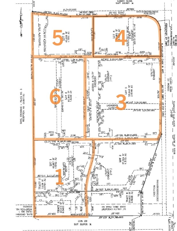
SUB:QUAIL CROSSING COMMERCIAL SUBDIVISION FILING NO 1 LOT:4
1573-28-1-25-006
ADAMS
Storebuilding
Colorado
2024
4
2025
1.15 AC
060100
North Denver
5,858 SF
Denver
NEARBY LISTINGS FOR SALE OR LEASE
DEMOGRAPHICS near 13591 Huron St
1 mile
3 mile
5 mile
2025 Total Population
8,836
88,802
252,814
2030 Population
9,225
91,981
262,002
Pop Growth 2025-2030
+ 4.40%
+ 3.58%
+ 3.63%
Average Age
37
38
39
2025 Total Households
2,902
33,458
92,531
HH Growth 2025-2030
+ 4.72%
+ 3.92%
+ 3.90%
Median Household Inc
$124,859
$112,578
$113,488
Avg Household Size
3.00
2.60
2.70
2025 Avg HH Vehicles
2.00
2.00
2.00
Median Home Value
$677,782
$662,995
$632,339
Median Year Built
1999
1998
1996
Nearby Places
Map Layers
Map Styles
 Street
 Aerial
Transit
 Traffic
 Biking
Places
Listings with unknown addresses are not visible on the map
- Restaurants
- Banks
- Shops
- Fitness
- Groceries
PUBLIC TRANSPORTATION
AIRPORT
Denver International
Drive
Walk
Distance
Denver International
33 min
28.2 mi
Freight Ports
Port of Shreveport
Drive
Walk
Distance
Port of Shreveport
1 min
821.9 mi
Nearby Properties
Address
Land Use
TOTAL SIZE
Lot Size
Zoning
Address
Land Use
TOTAL SIZE
Lot Size
Zoning
385,623 SF
32.77 AC
Address
Land Use
TOTAL SIZE
Lot Size
Zoning
332,908 SF
10.49 AC
Address
Land Use
TOTAL SIZE
Lot Size
Zoning
538,595 SF
87.92 AC
Address
Land Use
TOTAL SIZE
Lot Size
Zoning
712,276 SF
72.16 AC
Address
Land Use
TOTAL SIZE
Lot Size
Zoning
1,031,000 SF
31.98 AC
Address
Land Use
TOTAL SIZE
Lot Size
Zoning
154,914 SF
11.39 AC
Address
Land Use
TOTAL SIZE
Lot Size
Zoning
869,000 SF
61.97 AC
Address
Land Use
TOTAL SIZE
Lot Size
Zoning
424,498 SF
42.85 AC
Address
Land Use
TOTAL SIZE
Lot Size
Zoning
271,772 SF
21.57 AC
Address
Land Use
TOTAL SIZE
Lot Size
Zoning
202,491 SF
52.56 AC
PUD
Address
Land Use
TOTAL SIZE
Lot Size
Zoning
78,238 SF
181.60 AC
OLPF
Address
Land Use
TOTAL SIZE
Lot Size
Zoning
539,891 SF
30.35 AC
Address
Land Use
TOTAL SIZE
Lot Size
Zoning
506,255 SF
19.10 AC
Address
Land Use
TOTAL SIZE
Lot Size
Zoning
99,497 SF
11.02 AC
Address
Land Use
TOTAL SIZE
Lot Size
Zoning
244,459 SF
50.30 AC
Address
Land Use
TOTAL SIZE
Lot Size
Zoning
251,374 SF
20.95 AC
B-1
Address
Land Use
TOTAL SIZE
Lot Size
Zoning
1 SF
13.55 AC
Address
Land Use
TOTAL SIZE
Lot Size
Zoning
428,341 SF
22.35 AC
Address
Land Use
TOTAL SIZE
Lot Size
Zoning
547,908 SF
12.24 AC
Address
Land Use
TOTAL SIZE
Lot Size
Zoning
149,769 SF
20.71 AC
Address
Land Use
TOTAL SIZE
Lot Size
Zoning
74,610 SF
1.56 AC
Address
Land Use
TOTAL SIZE
Lot Size
Zoning
406,720 SF
17.59 AC
Address
Land Use
TOTAL SIZE
Lot Size
Zoning
150,494 SF
19.69 AC
PUDP
Address
Land Use
TOTAL SIZE
Lot Size
Zoning
325,764 SF
18.76 AC
Address
Land Use
TOTAL SIZE
Lot Size
Zoning
345,461 SF
15.99 AC
Address
Land Use
TOTAL SIZE
Lot Size
Zoning
172,200 SF
10.94 AC
Address
Land Use
TOTAL SIZE
Lot Size
Zoning
18,900 SF
60.88 AC
PUD
Address
Land Use
TOTAL SIZE
Lot Size
Zoning
162,240 SF
14.41 AC
Address
Land Use
TOTAL SIZE
Lot Size
Zoning
176,000 SF
12.03 AC
Address
Land Use
TOTAL SIZE
Lot Size
Zoning
297,172 SF
24.11 AC
The World's #1 Commercial Real Estate Marketplace
Connect with us
© 2026 CoStar Group
The information above has been obtained from sources believed reliable. While we do not doubt its accuracy we have not verified it and make no guarantee, warranty or representation about it. It is your responsibility to independently confirm its accuracy and completeness. Any projections, opinions, assumptions, or estimates used are for example only and do not represent the current or future performance of the property. The value of this transaction to you depends on tax and other factors which should be evaluated by your tax, financial, and legal advisors. You and your advisors should conduct a careful, independent investigation of the property to determine to your satisfaction the suitability of the property for your needs.