Property Record
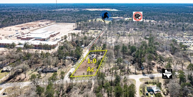
13598 Grangerland Rd, Conroe, TX 77306

NEARBY LISTINGS FOR SALE OR LEASE
Property Detail
13598 Grangerland Rd
0734-00-00400
Granger C E
Residentialacreage
A0734 - GRANGER C E, TRACT 4, ACRES 1
X
Montgomery
48339C0425G
Texas
2024
1.04 AC
2025
Outlying Montgomery Cnty
692701
Houston
1,304 SF
Houston-Pasadena-The Woodlands, TX
DEMOGRAPHICS near 13598 Grangerland Rd
1 Mile
3 Mile
5 Mile
2024 Total Population
1,231
12,985
31,463
2029 Population
1,509
16,178
39,237
Pop Growth 2024-2029
+ 22.58%
+ 24.59%
+ 24.71%
Average Age
38
36
35
2024 Total Households
436
4,184
9,759
HH Growth 2024-2029
+ 22.71%
+ 24.64%
+ 24.82%
Median Household Inc
$48,833
$58,696
$60,561
Avg Household Size
2.80
3.00
3.10
2024 Avg HH Vehicles
2.00
2.00
2.00
Median Home Value
$157,936
$121,047
$154,188
Median Year Built
1994
2000
2001
Nearby Places
Map Layers
Map Styles
 Street
 Aerial
- Restaurants
- Banks
- Shops
- Fitness
- Groceries
PUBLIC TRANSPORTATION
AIRPORT
George Bush Intcntl/Houston
DRIVE
WALK
Distance
George Bush Intcntl/Houston
40 min
29.5 mi
Freight Ports
Port of Houston
DRIVE
WALK
Distance
Port of Houston
61 min
44.8 mi
SALE & LEASE HISTORY
LISTING DATE
SALE/LEASE

Mar 13, 2023
For Sale
Nearby Properties
Address
Land Use
TOTAL SIZE
Lot Size
Zoning
Address
Land Use
TOTAL SIZE
Lot Size
Zoning
305,900 SF
60.85 AC
1
Address
Land Use
TOTAL SIZE
Lot Size
Zoning
205,948 SF
23.14 AC
Address
Land Use
TOTAL SIZE
Lot Size
Zoning
149,817 SF
2 AC
1
Address
Land Use
TOTAL SIZE
Lot Size
Zoning
98,000 SF
18 AC
Address
Land Use
TOTAL SIZE
Lot Size
Zoning
61,000 SF
28.31 AC
Address
Land Use
TOTAL SIZE
Lot Size
Zoning
18,308 SF
2.68 AC
1
Address
Land Use
TOTAL SIZE
Lot Size
Zoning
61,000 SF
16.10 AC
1
Address
Land Use
TOTAL SIZE
Lot Size
Zoning
38,020 SF
28.47 AC
1
Address
Land Use
TOTAL SIZE
Lot Size
Zoning
6,286 SF
21.84 AC
Address
Land Use
TOTAL SIZE
Lot Size
Zoning
9,582 SF
10.46 AC
1
Address
Land Use
TOTAL SIZE
Lot Size
Zoning
9,020 SF
1.54 AC
Address
Land Use
TOTAL SIZE
Lot Size
Zoning
19,952 SF
2 AC
Address
Land Use
TOTAL SIZE
Lot Size
Zoning
8.87 AC
1
Address
Land Use
TOTAL SIZE
Lot Size
Zoning
9,180 SF
1.38 AC
1
Address
Land Use
TOTAL SIZE
Lot Size
Zoning
15,988 SF
46.22 AC
1
Address
Land Use
TOTAL SIZE
Lot Size
Zoning
12,000 SF
1.38 AC
1
Address
Land Use
TOTAL SIZE
Lot Size
Zoning
12,880 SF
5.86 AC
1
Address
Land Use
TOTAL SIZE
Lot Size
Zoning
14,992 SF
2.27 AC
1
Address
Land Use
TOTAL SIZE
Lot Size
Zoning
6,000 SF
1.25 AC
Address
Land Use
TOTAL SIZE
Lot Size
Zoning
26,310 SF
6.50 AC
1
Address
Land Use
TOTAL SIZE
Lot Size
Zoning
10,560 SF
2 AC
1
Address
Land Use
TOTAL SIZE
Lot Size
Zoning
25,364 SF
6.11 AC
1
Address
Land Use
TOTAL SIZE
Lot Size
Zoning
4,730 SF
2 AC
1
Address
Land Use
TOTAL SIZE
Lot Size
Zoning
9,828 SF
28.07 AC
1
Address
Land Use
TOTAL SIZE
Lot Size
Zoning
16,701 SF
3.06 AC
1
Address
Land Use
TOTAL SIZE
Lot Size
Zoning
7,344 SF
1.60 AC
1
Address
Land Use
TOTAL SIZE
Lot Size
Zoning
11,890 SF
11.67 AC
1
Address
Land Use
TOTAL SIZE
Lot Size
Zoning
10,800 SF
5 AC
Address
Land Use
TOTAL SIZE
Lot Size
Zoning
19,796 SF
6.81 AC
1
Address
Land Use
TOTAL SIZE
Lot Size
Zoning
10,832 SF
10 AC
1
The World's #1 Commercial Real Estate Marketplace
Connect with us
© 2026 CoStar Group
The information above has been obtained from sources believed reliable. While we do not doubt its accuracy we have not verified it and make no guarantee, warranty or representation about it. It is your responsibility to independently confirm its accuracy and completeness. Any projections, opinions, assumptions, or estimates used are for example only and do not represent the current or future performance of the property. The value of this transaction to you depends on tax and other factors which should be evaluated by your tax, financial, and legal advisors. You and your advisors should conduct a careful, independent investigation of the property to determine to your satisfaction the suitability of the property for your needs.