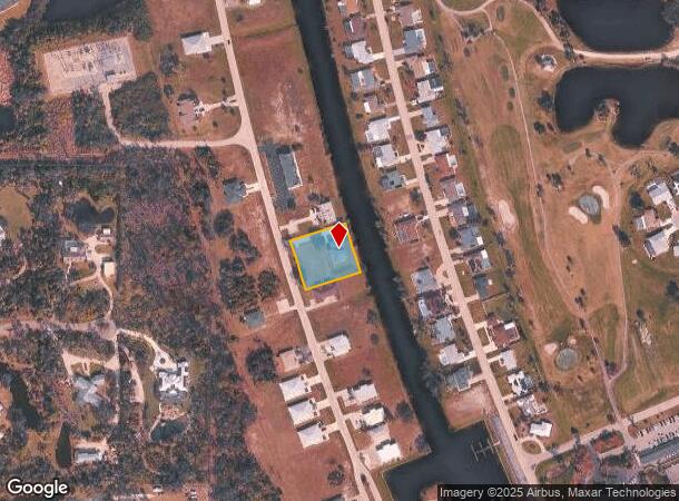
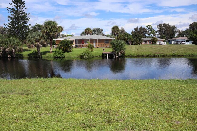
Property Record
136 Boundary Blvd, Rotonda West, FL 33947

NEARBY LISTINGS FOR SALE OR LEASE
-
-
View all Rotonda West listings for sale on LoopNet.com
Property Detail
136 Boundary Blvd
Punta Gorda, FL
Rotonda West Oakland Hills
412027203003
ROTONDA WEST OAKLAND HILLS LTS 952 & 953 836/2119 1299/2077 1401/955 2401/592 2631/658 CD2934/171 2948/1559 3025/723 3195/378 3708/2164 4918/1383
Quadruplex
Charlotte
AE
Florida
12015C0193G
952
2024
0.66 AC
2025
Port Charlotte
030505
Southwest Florida
3,818 SF
DEMOGRAPHICS near 136 Boundary Blvd
1 mile
3 mile
5 mile
2024 Total Population
4,414
21,924
45,004
2029 Population
5,375
26,607
54,858
Pop Growth 2024-2029
+ 21.77%
+ 21.36%
+ 21.90%
Average Age
59
59
58
2024 Total Households
2,341
10,909
22,151
HH Growth 2024-2029
+ 22.00%
+ 21.57%
+ 22.17%
Median Household Inc
$46,679
$57,929
$59,442
Avg Household Size
1.90
2.00
2.00
2024 Avg HH Vehicles
1.00
2.00
2.00
Median Home Value
$226,267
$277,571
$273,444
Median Year Built
1986
1993
1991
Nearby Places
Map Layers
Map Styles
 Street
 Aerial
Transit
 Traffic
 Biking
Places
Listings with unknown addresses are not visible on the map
- Restaurants
- Banks
- Shops
- Fitness
- Groceries
PUBLIC TRANSPORTATION
AIRPORT
Punta Gorda
Drive
Walk
Distance
Punta Gorda
49 min
27.7 mi
Freight Ports
Port Manatee
Drive
Walk
Distance
Port Manatee
85 min
61.0 mi
SALE & LEASE HISTORY
LISTING DATE
SALE/LEASE

Oct 01, 2021
For Sale
Nearby Properties
Address
Land Use
TOTAL SIZE
Lot Size
Zoning
Address
Land Use
TOTAL SIZE
Lot Size
Zoning
2,387.99 AC
ES
Address
Land Use
TOTAL SIZE
Lot Size
Zoning
105,990 SF
17.30 AC
RMF15
Address
Land Use
TOTAL SIZE
Lot Size
Zoning
28,490 SF
172 AC
PKR
Address
Land Use
TOTAL SIZE
Lot Size
Zoning
33,654 SF
10.19 AC
RMF5
Address
Land Use
TOTAL SIZE
Lot Size
Zoning
107,736 SF
35.90 AC
RMF5
Address
Land Use
TOTAL SIZE
Lot Size
Zoning
38,036 SF
9.09 AC
RMF15
Address
Land Use
TOTAL SIZE
Lot Size
Zoning
101,160 SF
2.39 AC
CG
Address
Land Use
TOTAL SIZE
Lot Size
Zoning
25,777 SF
12.18 AC
PD
Address
Land Use
TOTAL SIZE
Lot Size
Zoning
25,685 SF
126.18 AC
RMF-T
Address
Land Use
TOTAL SIZE
Lot Size
Zoning
55,760 SF
3.18 AC
CG
Address
Land Use
TOTAL SIZE
Lot Size
Zoning
25,478 SF
11.06 AC
IG
Address
Land Use
TOTAL SIZE
Lot Size
Zoning
106,737 SF
20.80 AC
RMF5
Address
Land Use
TOTAL SIZE
Lot Size
Zoning
40,376 SF
11.18 AC
CG
Address
Land Use
TOTAL SIZE
Lot Size
Zoning
24,708 SF
14.89 AC
CT
Address
Land Use
TOTAL SIZE
Lot Size
Zoning
3,935 SF
36.92 AC
RMF10
Address
Land Use
TOTAL SIZE
Lot Size
Zoning
50,080 SF
5.09 AC
CG
Address
Land Use
TOTAL SIZE
Lot Size
Zoning
15.79 AC
CT
Address
Land Use
TOTAL SIZE
Lot Size
Zoning
7,700 SF
2.96 AC
RSF2
Address
Land Use
TOTAL SIZE
Lot Size
Zoning
4,063 SF
0.75 AC
RSF3.5
Address
Land Use
TOTAL SIZE
Lot Size
Zoning
38.60 AC
PD
Address
Land Use
TOTAL SIZE
Lot Size
Zoning
3,775 SF
0.27 AC
BBI
Address
Land Use
TOTAL SIZE
Lot Size
Zoning
1,525 SF
2.54 AC
BBI
Address
Land Use
TOTAL SIZE
Lot Size
Zoning
26,248 SF
6.32 AC
PD
Address
Land Use
TOTAL SIZE
Lot Size
Zoning
25,130 SF
21.98 AC
RE1
Address
Land Use
TOTAL SIZE
Lot Size
Zoning
4,158 SF
0.41 AC
BBI
Address
Land Use
TOTAL SIZE
Lot Size
Zoning
27,501 SF
3.82 AC
CG
Address
Land Use
TOTAL SIZE
Lot Size
Zoning
1,282 SF
0.83 AC
RSF2
Address
Land Use
TOTAL SIZE
Lot Size
Zoning
20,160 SF
3.04 AC
CG
Address
Land Use
TOTAL SIZE
Lot Size
Zoning
14,391 SF
1.56 AC
RSF2
Address
Land Use
TOTAL SIZE
Lot Size
Zoning
1,623 SF
0.53 AC
BBI
The World's #1 Commercial Real Estate Marketplace
Connect with us
© 2026 CoStar Group
The information above has been obtained from sources believed reliable. While we do not doubt its accuracy we have not verified it and make no guarantee, warranty or representation about it. It is your responsibility to independently confirm its accuracy and completeness. Any projections, opinions, assumptions, or estimates used are for example only and do not represent the current or future performance of the property. The value of this transaction to you depends on tax and other factors which should be evaluated by your tax, financial, and legal advisors. You and your advisors should conduct a careful, independent investigation of the property to determine to your satisfaction the suitability of the property for your needs.