Property Record
136 Canyon Dr, Raton, NM 87740
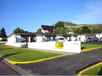

Property Detail
136 Canyon Dr
13119
SUBD: MAXWELL NORTH ADDITION BLOCK: 14 UPC 1135186262272 LAND 1 LOTS 1 THROUGH 5 40 X 140 S OF LOT 1 SUBD: MAXWELL NORTH ADDI
Commercialnec
Colfax
B and X Area of moderate flood hazard, usually the area between the limits of the 100-year and 500-year floods.
New Mexico
0
1-24
2025
0.82 AC
950500
New Mexico North Area
11,013 SF
Other Market Areas
NEARBY LISTINGS FOR SALE OR LEASE
-
-
View all Raton listings for sale on LoopNet.com
DEMOGRAPHICS near 136 Canyon Dr
1 mile
3 mile
5 mile
2025 Total Population
3,414
6,209
6,587
2030 Population
3,398
6,115
6,479
Pop Growth 2025-2030
(0.47%)
(1.51%)
(1.64%)
Average Age
45
45
45
2025 Total Households
1,586
2,767
2,923
HH Growth 2025-2030
(0.44%)
(1.59%)
(1.74%)
Median Household Inc
$52,346
$52,596
$51,750
Avg Household Size
2.10
2.10
2.10
2025 Avg HH Vehicles
2.00
2.00
2.00
Median Home Value
$135,427
$147,986
$148,815
Median Year Built
1956
1962
1964
Nearby Places
Map Layers
Map Styles
 Street
 Aerial
Layers
 Traffic
 Biking
Places
Listings with unknown addresses are not visible on the map
- Restaurants
- Banks
- Shops
- Fitness
- Groceries
PUBLIC TRANSPORTATION
COMMUTER RAIL
Raton (Southwest Chief - Amtrak)
Drive
Walk
Distance
Raton (Southwest Chief - Amtrak)
1 min
8 min
0.4 mi
Freight Ports
Tulsa Port Of Catoosa
Drive
Walk
Distance
Tulsa Port Of Catoosa
624 min
533.4 mi
SALE & LEASE HISTORY
LISTING DATE
SALE/LEASE

Jun 07, 2019
For Sale
Nearby Properties
Address
Land Use
TOTAL SIZE
Lot Size
Zoning
Address
Land Use
TOTAL SIZE
Lot Size
Zoning
Address
Land Use
TOTAL SIZE
Lot Size
Zoning
0.96 AC
Address
Land Use
TOTAL SIZE
Lot Size
Zoning
2.09 AC
Address
Land Use
TOTAL SIZE
Lot Size
Zoning
31.42 AC
Address
Land Use
TOTAL SIZE
Lot Size
Zoning
11.99 AC
Address
Land Use
TOTAL SIZE
Lot Size
Zoning
Address
Land Use
TOTAL SIZE
Lot Size
Zoning
96 AC
Address
Land Use
TOTAL SIZE
Lot Size
Zoning
104.81 AC
Address
Land Use
TOTAL SIZE
Lot Size
Zoning
4.69 AC
Address
Land Use
TOTAL SIZE
Lot Size
Zoning
Address
Land Use
TOTAL SIZE
Lot Size
Zoning
Address
Land Use
TOTAL SIZE
Lot Size
Zoning
10 AC
Address
Land Use
TOTAL SIZE
Lot Size
Zoning
22,848 SF
3.32 AC
Address
Land Use
TOTAL SIZE
Lot Size
Zoning
2.56 AC
Address
Land Use
TOTAL SIZE
Lot Size
Zoning
Address
Land Use
TOTAL SIZE
Lot Size
Zoning
46,000 SF
3.93 AC
Address
Land Use
TOTAL SIZE
Lot Size
Zoning
2.50 AC
Address
Land Use
TOTAL SIZE
Lot Size
Zoning
0.91 AC
Address
Land Use
TOTAL SIZE
Lot Size
Zoning
26,948 SF
1 AC
Address
Land Use
TOTAL SIZE
Lot Size
Zoning
18 AC
Address
Land Use
TOTAL SIZE
Lot Size
Zoning
0.16 AC
Address
Land Use
TOTAL SIZE
Lot Size
Zoning
0.40 AC
Address
Land Use
TOTAL SIZE
Lot Size
Zoning
Address
Land Use
TOTAL SIZE
Lot Size
Zoning
0.32 AC
Address
Land Use
TOTAL SIZE
Lot Size
Zoning
0.84 AC
Address
Land Use
TOTAL SIZE
Lot Size
Zoning
75,264 SF
6.70 AC
Address
Land Use
TOTAL SIZE
Lot Size
Zoning
10 AC
Address
Land Use
TOTAL SIZE
Lot Size
Zoning
2.02 AC
Address
Land Use
TOTAL SIZE
Lot Size
Zoning
Address
Land Use
TOTAL SIZE
Lot Size
Zoning
23,925 SF
2.39 AC
The World's #1 Commercial Real Estate Marketplace
Connect with us
© 2026 CoStar Group
The information above has been obtained from sources believed reliable. While we do not doubt its accuracy we have not verified it and make no guarantee, warranty or representation about it. It is your responsibility to independently confirm its accuracy and completeness. Any projections, opinions, assumptions, or estimates used are for example only and do not represent the current or future performance of the property. The value of this transaction to you depends on tax and other factors which should be evaluated by your tax, financial, and legal advisors. You and your advisors should conduct a careful, independent investigation of the property to determine to your satisfaction the suitability of the property for your needs.