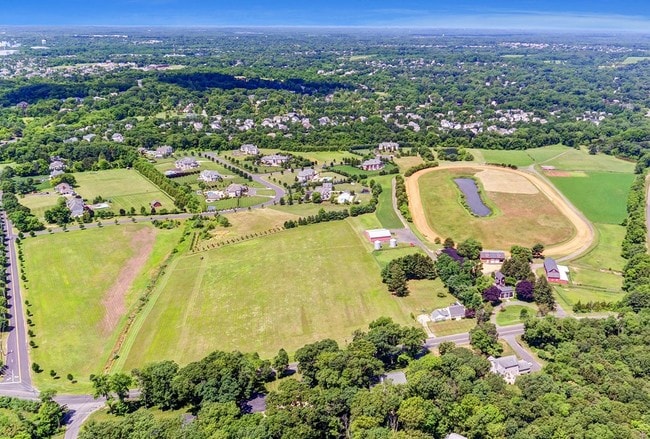
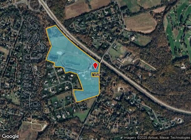
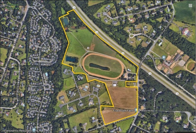
Property Record
136 Five Points Rd, Colts Neck, NJ 07722
NEARBY LISTINGS FOR SALE OR LEASE
Property Detail
136 Five Points Rd
10-00041-01-00005-13
Monmouth
Farms
New Jersey
X
5.13
34025C0164F
1 AC
2024
Western Monmouth
2025
Northern New Jersey
809902
Lakewood-New Brunswick, NJ
2,250 SF
DEMOGRAPHICS near 136 Five Points Rd
1 Mile
3 Mile
5 Mile
2024 Total Population
2,202
18,419
69,404
2029 Population
2,175
18,155
68,552
Pop Growth 2024-2029
(1.23%)
(1.43%)
(1.23%)
Average Age
41
41
42
2024 Total Households
729
6,055
23,950
HH Growth 2024-2029
(1.51%)
(1.68%)
(1.40%)
Median Household Inc
$182,175
$161,111
$126,198
Avg Household Size
2.90
2.90
2.80
2024 Avg HH Vehicles
2.00
2.00
2.00
Median Home Value
$758,454
$676,161
$566,530
Median Year Built
1991
1984
1981
Nearby Places
Map Layers
Map Styles
 Street
 Aerial
- Restaurants
- Banks
- Shops
- Fitness
- Groceries
PUBLIC TRANSPORTATION
AIRPORT
Newark Liberty International
DRIVE
WALK
Distance
Newark Liberty International
52 min
41.6 mi
Freight Ports
New York Container Terminal
DRIVE
WALK
Distance
New York Container Terminal
45 min
33.8 mi
SALE & LEASE HISTORY
LISTING DATE
SALE/LEASE

Aug 01, 2019
For Sale
Nearby Properties
Address
Land Use
TOTAL SIZE
Lot Size
Zoning
Address
Land Use
TOTAL SIZE
Lot Size
Zoning
3,255.78 AC
ARE6
Address
Land Use
TOTAL SIZE
Lot Size
Zoning
904,310 SF
85.13 AC
M2M1
Address
Land Use
TOTAL SIZE
Lot Size
Zoning
36.48 AC
HD-2
Address
Land Use
TOTAL SIZE
Lot Size
Zoning
267,666 SF
29.06 AC
M-1
Address
Land Use
TOTAL SIZE
Lot Size
Zoning
69.99 AC
AG
Address
Land Use
TOTAL SIZE
Lot Size
Zoning
73,884 SF
37.60 AC
R-40
Address
Land Use
TOTAL SIZE
Lot Size
Zoning
114,738 SF
19.02 AC
M-1
Address
Land Use
TOTAL SIZE
Lot Size
Zoning
42,982 SF
118.30 AC
R-40
Address
Land Use
TOTAL SIZE
Lot Size
Zoning
2.91 AC
RCR
Address
Land Use
TOTAL SIZE
Lot Size
Zoning
241.06 AC
AG
Address
Land Use
TOTAL SIZE
Lot Size
Zoning
19.02 AC
HD
Address
Land Use
TOTAL SIZE
Lot Size
Zoning
1.06 AC
AG
Address
Land Use
TOTAL SIZE
Lot Size
Zoning
200,294 SF
12 AC
R10
Address
Land Use
TOTAL SIZE
Lot Size
Zoning
93.79 AC
R-60
Address
Land Use
TOTAL SIZE
Lot Size
Zoning
1,800 SF
83.93 AC
R120
Address
Land Use
TOTAL SIZE
Lot Size
Zoning
92,832 SF
29.69 AC
M-1
Address
Land Use
TOTAL SIZE
Lot Size
Zoning
126,300 SF
10.12 AC
M-1
Address
Land Use
TOTAL SIZE
Lot Size
Zoning
448,934 SF
24.24 AC
C-M
Address
Land Use
TOTAL SIZE
Lot Size
Zoning
56,000 SF
21.53 AC
M-1
Address
Land Use
TOTAL SIZE
Lot Size
Zoning
8.32 AC
R-40
Address
Land Use
TOTAL SIZE
Lot Size
Zoning
155,980 SF
23.83 AC
M-1
Address
Land Use
TOTAL SIZE
Lot Size
Zoning
119,817 SF
23 AC
R-60
Address
Land Use
TOTAL SIZE
Lot Size
Zoning
4,812 SF
179.80 AC
A-1
Address
Land Use
TOTAL SIZE
Lot Size
Zoning
49.95 AC
M-2
Address
Land Use
TOTAL SIZE
Lot Size
Zoning
39,321 SF
6.77 AC
C125
Address
Land Use
TOTAL SIZE
Lot Size
Zoning
61,840 SF
12.32 AC
LI-3
Address
Land Use
TOTAL SIZE
Lot Size
Zoning
42,354 SF
0.92 AC
LI-3
Address
Land Use
TOTAL SIZE
Lot Size
Zoning
36 AC
R-60
Address
Land Use
TOTAL SIZE
Lot Size
Zoning
35.45 AC
R-60
Address
Land Use
TOTAL SIZE
Lot Size
Zoning
64,871 SF
15 AC
R-60
The World's #1 Commercial Real Estate Marketplace
Connect with us
© 2026 CoStar Group
The information above has been obtained from sources believed reliable. While we do not doubt its accuracy we have not verified it and make no guarantee, warranty or representation about it. It is your responsibility to independently confirm its accuracy and completeness. Any projections, opinions, assumptions, or estimates used are for example only and do not represent the current or future performance of the property. The value of this transaction to you depends on tax and other factors which should be evaluated by your tax, financial, and legal advisors. You and your advisors should conduct a careful, independent investigation of the property to determine to your satisfaction the suitability of the property for your needs.