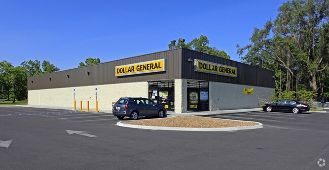
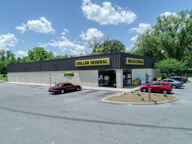
Property Record
136 Nw Bascom Norris Dr, Lake City, FL 32055

Save to a Folder
{{folder.Name}}
{{folder.ListingIds.length}} Properties
{{folder.ListingIds.length}} Property
Create a New Folder
Property Detail
136 Nw Bascom Norris Dr
00-00-00-11572-000
NW DIV: BEG AT INTERS S R/W LI
Storemultistory
Columbia
CG
Florida
B and X Area of moderate flood hazard, usually the area between the limits of the 100-year and 500-year floods.
2.54 AC
2024
Florida Central North Area
2026
Other Market Areas
110202
Lake City, FL
10,858 SF
NEARBY LISTINGS FOR SALE OR LEASE
DEMOGRAPHICS near 136 Nw Bascom Norris Dr
1 mile
3 mile
5 mile
2025 Total Population
3,735
17,647
32,630
2030 Population
4,041
18,703
34,504
Pop Growth 2025-2030
+ 8.19%
+ 5.98%
+ 5.74%
Average Age
39
40
41
2025 Total Households
1,406
6,777
12,234
HH Growth 2025-2030
+ 8.61%
+ 6.26%
+ 6.04%
Median Household Inc
$47,929
$52,729
$56,759
Avg Household Size
2.50
2.40
2.40
2025 Avg HH Vehicles
2.00
2.00
2.00
Median Home Value
$126,190
$165,242
$210,394
Median Year Built
1976
1979
1985
Nearby Places
Map Layers
Map Styles
 Street
 Aerial
Layers
 Traffic
 Biking
Places
Listings with unknown addresses are not visible on the map
- Restaurants
- Banks
- Shops
- Fitness
- Groceries
SALE & LEASE HISTORY
LISTING DATE
SALE/LEASE

May 14, 2019
For Sale
Nearby Properties
Address
Land Use
TOTAL SIZE
Lot Size
Zoning
Address
Land Use
TOTAL SIZE
Lot Size
Zoning
800,000 SF
35.90 AC
RO
Address
Land Use
TOTAL SIZE
Lot Size
Zoning
425,035 SF
76.83 AC
CHI
Address
Land Use
TOTAL SIZE
Lot Size
Zoning
136,724 SF
13.10 AC
CI
Address
Land Use
TOTAL SIZE
Lot Size
Zoning
97,918 SF
50 AC
ILW
Address
Land Use
TOTAL SIZE
Lot Size
Zoning
11.98 AC
RSF-2
Address
Land Use
TOTAL SIZE
Lot Size
Zoning
301,357 SF
70.39 AC
Address
Land Use
TOTAL SIZE
Lot Size
Zoning
167,663 SF
11.62 AC
RMF-2
Address
Land Use
TOTAL SIZE
Lot Size
Zoning
112,272 SF
6.08 AC
RO
Address
Land Use
TOTAL SIZE
Lot Size
Zoning
220,228 SF
22.22 AC
CG
Address
Land Use
TOTAL SIZE
Lot Size
Zoning
144,355 SF
49 AC
RSFMH2
Address
Land Use
TOTAL SIZE
Lot Size
Zoning
142,790 SF
27.87 AC
RSF-2
Address
Land Use
TOTAL SIZE
Lot Size
Zoning
76,271 SF
38 AC
I
Address
Land Use
TOTAL SIZE
Lot Size
Zoning
71,293 SF
10.17 AC
CI
Address
Land Use
TOTAL SIZE
Lot Size
Zoning
20.08 AC
Address
Land Use
TOTAL SIZE
Lot Size
Zoning
127,012 SF
25.19 AC
Address
Land Use
TOTAL SIZE
Lot Size
Zoning
112,471 SF
15.66 AC
CG
Address
Land Use
TOTAL SIZE
Lot Size
Zoning
310,629 SF
33.79 AC
Address
Land Use
TOTAL SIZE
Lot Size
Zoning
44,124 SF
53 AC
Address
Land Use
TOTAL SIZE
Lot Size
Zoning
133,076 SF
14.57 AC
A-1
Address
Land Use
TOTAL SIZE
Lot Size
Zoning
47,552 SF
5.73 AC
CI
Address
Land Use
TOTAL SIZE
Lot Size
Zoning
66,346 SF
7.75 AC
RSF-3
Address
Land Use
TOTAL SIZE
Lot Size
Zoning
83,595 SF
1.01 AC
C-CBD
Address
Land Use
TOTAL SIZE
Lot Size
Zoning
26,741 SF
114.62 AC
I
Address
Land Use
TOTAL SIZE
Lot Size
Zoning
141,355 SF
27 AC
RSFMH2
Address
Land Use
TOTAL SIZE
Lot Size
Zoning
81,848 SF
3.28 AC
RMF-1
Address
Land Use
TOTAL SIZE
Lot Size
Zoning
77,731 SF
23.50 AC
RSF-2
Address
Land Use
TOTAL SIZE
Lot Size
Zoning
42,004 SF
40.40 AC
CG
Address
Land Use
TOTAL SIZE
Lot Size
Zoning
79,684 SF
7.87 AC
RSFMH2
Address
Land Use
TOTAL SIZE
Lot Size
Zoning
75,395 SF
12.03 AC
RSF-3
Address
Land Use
TOTAL SIZE
Lot Size
Zoning
24,373 SF
2.51 AC
The World's #1 Commercial Real Estate Marketplace
Connect with us
© 2026 CoStar Group
The information above has been obtained from sources believed reliable. While we do not doubt its accuracy we have not verified it and make no guarantee, warranty or representation about it. It is your responsibility to independently confirm its accuracy and completeness. Any projections, opinions, assumptions, or estimates used are for example only and do not represent the current or future performance of the property. The value of this transaction to you depends on tax and other factors which should be evaluated by your tax, financial, and legal advisors. You and your advisors should conduct a careful, independent investigation of the property to determine to your satisfaction the suitability of the property for your needs.