Property Record
136 S 6Th St, Springfield, OR 97477
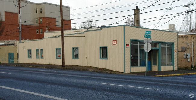


Property Detail
136 S 6Th St
Eugene-Springfield, OR
TL 11100
0313948
Lane
Commercialbuilding
Oregon
MUC
11100
B and X Area of moderate flood hazard, usually the area between the limits of the 100-year and 500-year floods.
0.08 AC
2025
Lane County
2025
Portland
003302
NEARBY LISTINGS FOR SALE OR LEASE
DEMOGRAPHICS near 136 S 6Th St
1 mile
3 mile
5 mile
2025 Total Population
9,585
74,009
163,741
2030 Population
9,398
73,718
162,652
Pop Growth 2025-2030
(1.95%)
(0.39%)
(0.67%)
Average Age
41
38
39
2025 Total Households
4,426
28,832
68,607
HH Growth 2025-2030
(2.01%)
(0.52%)
(0.79%)
Median Household Inc
$56,615
$65,747
$65,571
Avg Household Size
2.10
2.30
2.20
2025 Avg HH Vehicles
2.00
2.00
2.00
Median Home Value
$304,818
$417,035
$456,885
Median Year Built
1966
1974
1974
Nearby Places
Map Layers
Map Styles
 Street
 Aerial
Layers
 Traffic
 Biking
Places
Listings with unknown addresses are not visible on the map
- Restaurants
- Banks
- Shops
- Fitness
- Groceries
PUBLIC TRANSPORTATION
COMMUTER RAIL
Drive
Walk
Distance
10 min
4.2 mi
AIRPORT
Mahlon Sweet Field
Drive
Walk
Distance
Mahlon Sweet Field
25 min
13.7 mi
SALE & LEASE HISTORY
LISTING DATE
SALE/LEASE

Apr 18, 2023
For Lease
Nearby Properties
Address
Land Use
TOTAL SIZE
Lot Size
Zoning
Address
Land Use
TOTAL SIZE
Lot Size
Zoning
110.25 AC
PL
Address
Land Use
TOTAL SIZE
Lot Size
Zoning
15.37 AC
PL
Address
Land Use
TOTAL SIZE
Lot Size
Zoning
71.87 AC
PL
Address
Land Use
TOTAL SIZE
Lot Size
Zoning
121.46 AC
E25
Address
Land Use
TOTAL SIZE
Lot Size
Zoning
1.56 AC
C-2
Address
Land Use
TOTAL SIZE
Lot Size
Zoning
1.86 AC
C-2
Address
Land Use
TOTAL SIZE
Lot Size
Zoning
9.57 AC
LD
Address
Land Use
TOTAL SIZE
Lot Size
Zoning
24 AC
C-2
Address
Land Use
TOTAL SIZE
Lot Size
Zoning
13.82 AC
PL
Address
Land Use
TOTAL SIZE
Lot Size
Zoning
9.81 AC
C-2
Address
Land Use
TOTAL SIZE
Lot Size
Zoning
3.10 AC
S-WS
Address
Land Use
TOTAL SIZE
Lot Size
Zoning
33.20 AC
HI
Address
Land Use
TOTAL SIZE
Lot Size
Zoning
22.52 AC
LD
Address
Land Use
TOTAL SIZE
Lot Size
Zoning
16.80 AC
PL
Address
Land Use
TOTAL SIZE
Lot Size
Zoning
3.29 AC
S-RP
Address
Land Use
TOTAL SIZE
Lot Size
Zoning
Address
Land Use
TOTAL SIZE
Lot Size
Zoning
2.15 AC
PL
Address
Land Use
TOTAL SIZE
Lot Size
Zoning
Address
Land Use
TOTAL SIZE
Lot Size
Zoning
17.37 AC
AG
Address
Land Use
TOTAL SIZE
Lot Size
Zoning
11.23 AC
Address
Land Use
TOTAL SIZE
Lot Size
Zoning
Address
Land Use
TOTAL SIZE
Lot Size
Zoning
Address
Land Use
TOTAL SIZE
Lot Size
Zoning
Address
Land Use
TOTAL SIZE
Lot Size
Zoning
50.28 AC
LD
Address
Land Use
TOTAL SIZE
Lot Size
Zoning
28.66 AC
LMI
Address
Land Use
TOTAL SIZE
Lot Size
Zoning
19.48 AC
LD
Address
Land Use
TOTAL SIZE
Lot Size
Zoning
11.77 AC
R-3
Address
Land Use
TOTAL SIZE
Lot Size
Zoning
35.91 AC
HI
Address
Land Use
TOTAL SIZE
Lot Size
Zoning
7.27 AC
PL
Address
Land Use
TOTAL SIZE
Lot Size
Zoning
14.80 AC
CI
The World's #1 Commercial Real Estate Marketplace
Connect with us
© 2026 CoStar Group
The information above has been obtained from sources believed reliable. While we do not doubt its accuracy we have not verified it and make no guarantee, warranty or representation about it. It is your responsibility to independently confirm its accuracy and completeness. Any projections, opinions, assumptions, or estimates used are for example only and do not represent the current or future performance of the property. The value of this transaction to you depends on tax and other factors which should be evaluated by your tax, financial, and legal advisors. You and your advisors should conduct a careful, independent investigation of the property to determine to your satisfaction the suitability of the property for your needs.