Property Record
136 S Main St, Assonet, MA 02702
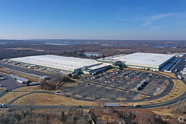

Property Detail
136 S Main St
FREE-000233-000000-000030-000003
Bristol
Industrialgeneral
Massachusetts
I
174.51 AC
AE The base floodplain where base flood elevations are provided. AE Zones are now used on new format FIRMs instead of A1-A30 Zones.
Attleboro/New Bedford
2024
Boston
2025
Providence-Warwick, RI-MA
617101
NEARBY LISTINGS FOR SALE OR LEASE
DEMOGRAPHICS near 136 S Main St
1 mile
3 mile
5 mile
2025 Total Population
512
17,381
50,313
2030 Population
518
17,749
51,349
Pop Growth 2025-2030
+ 1.17%
+ 2.12%
+ 2.06%
Average Age
42
43
43
2025 Total Households
179
6,824
19,713
HH Growth 2025-2030
+ 1.12%
+ 2.27%
+ 2.19%
Median Household Inc
$157,353
$102,607
$97,427
Avg Household Size
2.80
2.50
2.50
2025 Avg HH Vehicles
2.00
2.00
2.00
Median Home Value
$611,702
$474,718
$457,910
Median Year Built
1977
1975
1970
Nearby Places
Map Layers
Map Styles
 Street
 Aerial
Layers
 Traffic
 Biking
Places
Listings with unknown addresses are not visible on the map
- Restaurants
- Banks
- Shops
- Fitness
- Groceries
PUBLIC TRANSPORTATION
AIRPORT
Rhode Island Tf Green International
Drive
Walk
Distance
Rhode Island Tf Green International
48 min
28.3 mi
Freight Ports
Port of New Bedford Harbor
Drive
Walk
Distance
Port of New Bedford Harbor
29 min
19.8 mi
Nearby Properties
Address
Land Use
TOTAL SIZE
Lot Size
Zoning
Address
Land Use
TOTAL SIZE
Lot Size
Zoning
0.06 AC
A-2
Address
Land Use
TOTAL SIZE
Lot Size
Zoning
599,760 SF
33.60 AC
INPK
Address
Land Use
TOTAL SIZE
Lot Size
Zoning
387.83 AC
I
Address
Land Use
TOTAL SIZE
Lot Size
Zoning
104,822 SF
16.61 AC
R1
Address
Land Use
TOTAL SIZE
Lot Size
Zoning
17.18 AC
IND
Address
Land Use
TOTAL SIZE
Lot Size
Zoning
53.87 AC
N/A
Address
Land Use
TOTAL SIZE
Lot Size
Zoning
18.65 AC
A-2
Address
Land Use
TOTAL SIZE
Lot Size
Zoning
65.74 AC
B
Address
Land Use
TOTAL SIZE
Lot Size
Zoning
28,438 SF
245 AC
C
Address
Land Use
TOTAL SIZE
Lot Size
Zoning
497,656 SF
30.47 AC
INPK
Address
Land Use
TOTAL SIZE
Lot Size
Zoning
26.51 AC
G
Address
Land Use
TOTAL SIZE
Lot Size
Zoning
341,531 SF
17.57 AC
INPK
Address
Land Use
TOTAL SIZE
Lot Size
Zoning
199,138 SF
15.10 AC
INPK
Address
Land Use
TOTAL SIZE
Lot Size
Zoning
161,640 SF
5.59 AC
INPK
Address
Land Use
TOTAL SIZE
Lot Size
Zoning
1,930 AC
INPK
Address
Land Use
TOTAL SIZE
Lot Size
Zoning
9.65 AC
B-L
Address
Land Use
TOTAL SIZE
Lot Size
Zoning
4.33 AC
B
Address
Land Use
TOTAL SIZE
Lot Size
Zoning
107,712 SF
9.38 AC
B-L
Address
Land Use
TOTAL SIZE
Lot Size
Zoning
10,400 SF
54 AC
G
Address
Land Use
TOTAL SIZE
Lot Size
Zoning
297,041 SF
30.89 AC
INPK
Address
Land Use
TOTAL SIZE
Lot Size
Zoning
39,944 SF
47.07 AC
I2
Address
Land Use
TOTAL SIZE
Lot Size
Zoning
34.88 AC
G
Address
Land Use
TOTAL SIZE
Lot Size
Zoning
2,295.68 AC
OSR
Address
Land Use
TOTAL SIZE
Lot Size
Zoning
79,300 SF
10.84 AC
INPK
Address
Land Use
TOTAL SIZE
Lot Size
Zoning
83,628 SF
5.51 AC
R1
Address
Land Use
TOTAL SIZE
Lot Size
Zoning
87,806 SF
4 AC
B
Address
Land Use
TOTAL SIZE
Lot Size
Zoning
79,119 SF
10.91 AC
A-2
Address
Land Use
TOTAL SIZE
Lot Size
Zoning
1,780 SF
0.43 AC
A-2
Address
Land Use
TOTAL SIZE
Lot Size
Zoning
113,500 SF
9.56 AC
INPK
The World's #1 Commercial Real Estate Marketplace
Connect with us
© 2026 CoStar Group
The information above has been obtained from sources believed reliable. While we do not doubt its accuracy we have not verified it and make no guarantee, warranty or representation about it. It is your responsibility to independently confirm its accuracy and completeness. Any projections, opinions, assumptions, or estimates used are for example only and do not represent the current or future performance of the property. The value of this transaction to you depends on tax and other factors which should be evaluated by your tax, financial, and legal advisors. You and your advisors should conduct a careful, independent investigation of the property to determine to your satisfaction the suitability of the property for your needs.