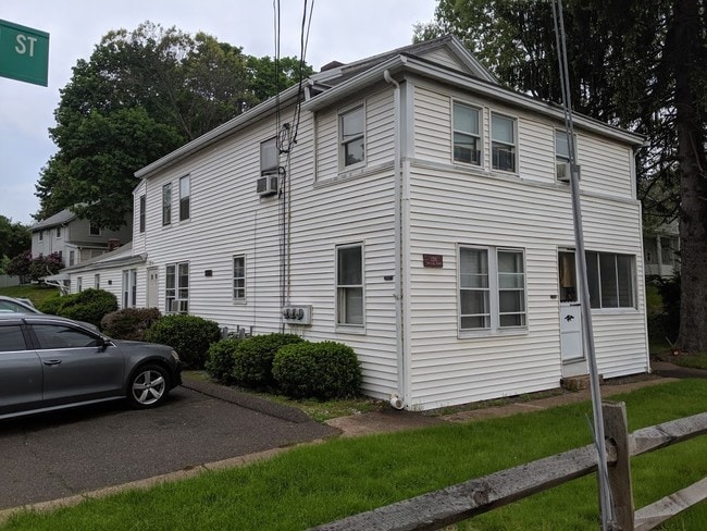
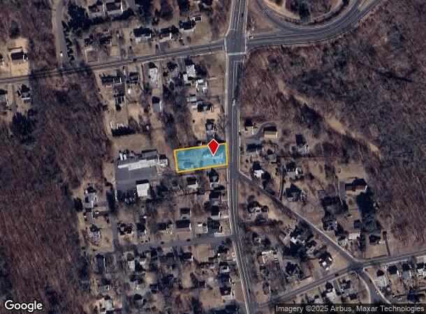
Property Record
136 S Main St, Manchester, CT 06040
NEARBY LISTINGS FOR SALE OR LEASE
Property Detail
136 S Main St
MANC-000081-005180-000136
Hartford
Multifamilydwelling
Connecticut
X
136
09003C0394F
0.39 AC
2025
Martin
2025
Hartford
515101
Hartford-West Hartford-East Hartford, CT
DEMOGRAPHICS near 136 S Main St
1 mile
3 mile
5 mile
2024 Total Population
10,547
53,140
116,404
2029 Population
10,447
52,850
115,949
Pop Growth 2024-2029
(0.95%)
(0.55%)
(0.39%)
Average Age
39
40
41
2024 Total Households
4,618
21,712
47,155
HH Growth 2024-2029
(0.97%)
(0.63%)
(0.43%)
Median Household Inc
$60,373
$79,683
$85,997
Avg Household Size
2.20
2.30
2.40
2024 Avg HH Vehicles
2.00
2.00
2.00
Median Home Value
$239,358
$225,559
$245,732
Median Year Built
1949
1958
1966
Nearby Places
Map Layers
Map Styles
 Street
 Aerial
Transit
 Traffic
 Biking
Places
Listings with unknown addresses are not visible on the map
- Restaurants
- Banks
- Shops
- Fitness
- Groceries
PUBLIC TRANSPORTATION
AIRPORT
Bradley International
Drive
Walk
Distance
Bradley International
25 min
21.1 mi
Freight Ports
Port of Davisville, RI
Drive
Walk
Distance
Port of Davisville, RI
1 min
58.2 mi
SALE & LEASE HISTORY
LISTING DATE
SALE/LEASE

Jun 06, 2019
For Sale
Nearby Properties
Address
Land Use
TOTAL SIZE
Lot Size
Zoning
Address
Land Use
TOTAL SIZE
Lot Size
Zoning
159 AC
RR
Address
Land Use
TOTAL SIZE
Lot Size
Zoning
12.54 AC
Address
Land Use
TOTAL SIZE
Lot Size
Zoning
20,384 SF
40 AC
PRD
Address
Land Use
TOTAL SIZE
Lot Size
Zoning
1,920 SF
31 AC
RC
Address
Land Use
TOTAL SIZE
Lot Size
Zoning
29.90 AC
PRD
Address
Land Use
TOTAL SIZE
Lot Size
Zoning
53.59 AC
RA
Address
Land Use
TOTAL SIZE
Lot Size
Zoning
219,479 SF
9.32 AC
H
Address
Land Use
TOTAL SIZE
Lot Size
Zoning
36 AC
RR
Address
Land Use
TOTAL SIZE
Lot Size
Zoning
22.12 AC
FBZ
Address
Land Use
TOTAL SIZE
Lot Size
Zoning
76,768 SF
6.03 AC
R-2
Address
Land Use
TOTAL SIZE
Lot Size
Zoning
187,657 SF
30.80 AC
RR
Address
Land Use
TOTAL SIZE
Lot Size
Zoning
6.38 AC
CBD
Address
Land Use
TOTAL SIZE
Lot Size
Zoning
79,198 SF
10.47 AC
RA
Address
Land Use
TOTAL SIZE
Lot Size
Zoning
195,772 SF
3.17 AC
H
Address
Land Use
TOTAL SIZE
Lot Size
Zoning
13.01 AC
B5
Address
Land Use
TOTAL SIZE
Lot Size
Zoning
6,612 SF
22 AC
RA
Address
Land Use
TOTAL SIZE
Lot Size
Zoning
72,383 SF
14.10 AC
RR/RB
Address
Land Use
TOTAL SIZE
Lot Size
Zoning
6.80 AC
H
Address
Land Use
TOTAL SIZE
Lot Size
Zoning
16 AC
RA
Address
Land Use
TOTAL SIZE
Lot Size
Zoning
128,739 SF
8.77 AC
EHD
Address
Land Use
TOTAL SIZE
Lot Size
Zoning
32,137 SF
11.95 AC
RR
Address
Land Use
TOTAL SIZE
Lot Size
Zoning
54,012 SF
16.64 AC
RA
Address
Land Use
TOTAL SIZE
Lot Size
Zoning
249,244 SF
27.23 AC
IND
Address
Land Use
TOTAL SIZE
Lot Size
Zoning
129,700 SF
3.60 AC
H
Address
Land Use
TOTAL SIZE
Lot Size
Zoning
180.46 AC
IND
Address
Land Use
TOTAL SIZE
Lot Size
Zoning
119,542 SF
3.80 AC
RB/HIS
Address
Land Use
TOTAL SIZE
Lot Size
Zoning
116,258 SF
3.22 AC
RA
Address
Land Use
TOTAL SIZE
Lot Size
Zoning
69,160 SF
7.65 AC
FBZ
Address
Land Use
TOTAL SIZE
Lot Size
Zoning
30,443 SF
2.59 AC
RB
Address
Land Use
TOTAL SIZE
Lot Size
Zoning
7.70 AC
RA
The World's #1 Commercial Real Estate Marketplace
Connect with us
© 2026 CoStar Group
The information above has been obtained from sources believed reliable. While we do not doubt its accuracy we have not verified it and make no guarantee, warranty or representation about it. It is your responsibility to independently confirm its accuracy and completeness. Any projections, opinions, assumptions, or estimates used are for example only and do not represent the current or future performance of the property. The value of this transaction to you depends on tax and other factors which should be evaluated by your tax, financial, and legal advisors. You and your advisors should conduct a careful, independent investigation of the property to determine to your satisfaction the suitability of the property for your needs.