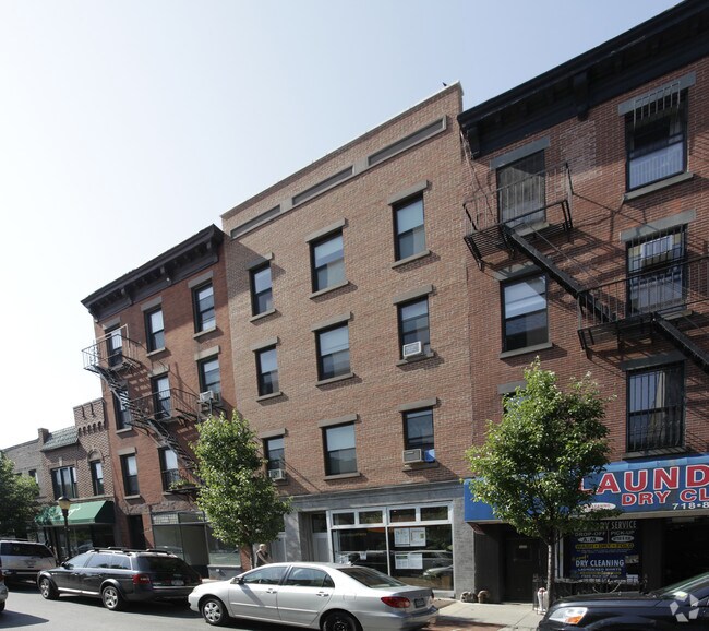
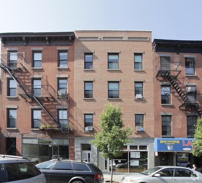
Property Record
136 Union St, Brooklyn, NY 11231


Property Detail
136 Union St
00342-0020
DOCID-2016090701004001
Commercialofficeresidentialmixeduse
Kings
R6B
New York
B and X Area of moderate flood hazard, usually the area between the limits of the 100-year and 500-year floods.
20
2024
0.06 AC
2025
North Brooklyn
005100
Long Island (New York)
6,294 SF
New York-Jersey City-White Plains, NY-NJ
NEARBY LISTINGS FOR SALE OR LEASE
DEMOGRAPHICS near 136 Union St
1 mile
3 mile
5 mile
2025 Total Population
81,857
866,486
2,659,414
2030 Population
82,458
882,544
2,700,568
Pop Growth 2025-2030
+ 0.73%
+ 1.85%
+ 1.55%
Average Age
39
38
38
2025 Total Households
36,268
359,713
1,085,050
HH Growth 2025-2030
+ 0.36%
+ 2.06%
+ 1.95%
Median Household Inc
$154,258
$112,769
$98,312
Avg Household Size
2.20
2.30
2.30
2025 Avg HH Vehicles
.00
.00
.00
Median Home Value
$1,083,576
$1,047,461
$980,594
Median Year Built
1947
1949
1949
Nearby Places
Map Layers
Map Styles
 Street
 Aerial
Transit
 Traffic
 Biking
Places
Listings with unknown addresses are not visible on the map
- Restaurants
- Banks
- Shops
- Fitness
- Groceries
PUBLIC TRANSPORTATION
TRANSIT/SUBWAY
Carroll Street (F - New York MTA Subway (The Subway), G - New York MTA Subway (The Subway))
Drive
Walk
Distance
Carroll Street (F - New York MTA Subway (The Subway), G - New York MTA Subway (The Subway))
2 min
10 min
0.6 mi
Bergen Street (F,G Line) (F - New York MTA Subway (The Subway), G - New York MTA Subway (The Subway))
Drive
Walk
Distance
Bergen Street (F,G Line) (F - New York MTA Subway (The Subway), G - New York MTA Subway (The Subway))
2 min
16 min
0.9 mi
Smith-9 Streets (F - New York MTA Subway (The Subway), G - New York MTA Subway (The Subway))
Drive
Walk
Distance
Smith-9 Streets (F - New York MTA Subway (The Subway), G - New York MTA Subway (The Subway))
3 min
17 min
0.9 mi
Court St (Broadway Local - MTA New York City Transit)
Drive
Walk
Distance
Court St (Broadway Local - MTA New York City Transit)
4 min
20 min
1.1 mi
COMMUTER RAIL
Atlantic Terminal (Babylon Branch - Long Island Rail Road, City Terminal Zone - Long Island Rail Road, Hempstead Branch - Long Island Rail Road, West Hempstead Branch - Long Island Rail Road)
Drive
Walk
Distance
Atlantic Terminal (Babylon Branch - Long Island Rail Road, City Terminal Zone - Long Island Rail Road, Hempstead Branch - Long Island Rail Road, West Hempstead Branch - Long Island Rail Road)
7 min
2.0 mi
Exchange Place (Hoboken-World Trade Center - Port Authority Trans-Hudson (PATH), Newark Penn Station-World Trade Center - Port Authority Trans-Hudson (PATH))
Drive
Walk
Distance
Exchange Place (Hoboken-World Trade Center - Port Authority Trans-Hudson (PATH), Newark Penn Station-World Trade Center - Port Authority Trans-Hudson (PATH))
17 min
7.1 mi
AIRPORT
LaGuardia
Drive
Walk
Distance
LaGuardia
21 min
11.4 mi
Newark Liberty International
Drive
Walk
Distance
Newark Liberty International
26 min
15.4 mi
John F Kennedy International
Drive
Walk
Distance
John F Kennedy International
29 min
15.9 mi
Freight Ports
NY - Red Hook Container Terminal
Drive
Walk
Distance
NY - Red Hook Container Terminal
1 min
0.3 mi
SALE & LEASE HISTORY
LISTING DATE
SALE/LEASE

Nov 07, 2019
For Lease
May 24, 2024
For Lease
Nearby Properties
Address
Land Use
TOTAL SIZE
Lot Size
Zoning
Address
Land Use
TOTAL SIZE
Lot Size
Zoning
2,354,289 SF
3.96 AC
C6-4
Address
Land Use
TOTAL SIZE
Lot Size
Zoning
2,812,739 SF
2.10 AC
C5-3
Address
Land Use
TOTAL SIZE
Lot Size
Zoning
2.38 AC
Address
Land Use
TOTAL SIZE
Lot Size
Zoning
1.75 AC
Address
Land Use
TOTAL SIZE
Lot Size
Zoning
2,157,862 SF
2.23 AC
BPC
Address
Land Use
TOTAL SIZE
Lot Size
Zoning
2,255,659 SF
4.58 AC
BPC
Address
Land Use
TOTAL SIZE
Lot Size
Zoning
Address
Land Use
TOTAL SIZE
Lot Size
Zoning
6.42 AC
Address
Land Use
TOTAL SIZE
Lot Size
Zoning
2,233,692 SF
1.90 AC
BPC
Address
Land Use
TOTAL SIZE
Lot Size
Zoning
2.21 AC
Address
Land Use
TOTAL SIZE
Lot Size
Zoning
1,636,000 SF
1.09 AC
C6-4
Address
Land Use
TOTAL SIZE
Lot Size
Zoning
1,909,502 SF
2.37 AC
BPC
Address
Land Use
TOTAL SIZE
Lot Size
Zoning
1,780,030 SF
5.07 AC
BPC
Address
Land Use
TOTAL SIZE
Lot Size
Zoning
7,058,736 SF
147.61 AC
M3-1
Address
Land Use
TOTAL SIZE
Lot Size
Zoning
869,038 SF
1.53 AC
M1-1
Address
Land Use
TOTAL SIZE
Lot Size
Zoning
1.04 AC
Address
Land Use
TOTAL SIZE
Lot Size
Zoning
1,260,362 SF
4.32 AC
C1-7
Address
Land Use
TOTAL SIZE
Lot Size
Zoning
1.84 AC
Address
Land Use
TOTAL SIZE
Lot Size
Zoning
92,440 SF
466.23 AC
R5
Address
Land Use
TOTAL SIZE
Lot Size
Zoning
802,000 SF
1.20 AC
C62A
Address
Land Use
TOTAL SIZE
Lot Size
Zoning
2,210,200 SF
2.58 AC
C5-5
Address
Land Use
TOTAL SIZE
Lot Size
Zoning
1,362,190 SF
C5-5
Address
Land Use
TOTAL SIZE
Lot Size
Zoning
1,653,794 SF
3.15 AC
C6-4
Address
Land Use
TOTAL SIZE
Lot Size
Zoning
932,587 SF
1.23 AC
C5-3
Address
Land Use
TOTAL SIZE
Lot Size
Zoning
972,820 SF
1.98 AC
M1-6
Address
Land Use
TOTAL SIZE
Lot Size
Zoning
1,499,568 SF
1.66 AC
C5-5
Address
Land Use
TOTAL SIZE
Lot Size
Zoning
Address
Land Use
TOTAL SIZE
Lot Size
Zoning
1,440,960 SF
2.17 AC
BPC
Address
Land Use
TOTAL SIZE
Lot Size
Zoning
4,000 SF
57.37 AC
BPC
Address
Land Use
TOTAL SIZE
Lot Size
Zoning
1,740,736 SF
4.29 AC
C6-4
The World's #1 Commercial Real Estate Marketplace
Connect with us
© 2026 CoStar Group
The information above has been obtained from sources believed reliable. While we do not doubt its accuracy we have not verified it and make no guarantee, warranty or representation about it. It is your responsibility to independently confirm its accuracy and completeness. Any projections, opinions, assumptions, or estimates used are for example only and do not represent the current or future performance of the property. The value of this transaction to you depends on tax and other factors which should be evaluated by your tax, financial, and legal advisors. You and your advisors should conduct a careful, independent investigation of the property to determine to your satisfaction the suitability of the property for your needs.