Property Record
1360 Scheuring Rd, De Pere, WI 54115

Property Detail
1360 Scheuring Rd
Green Bay, WI
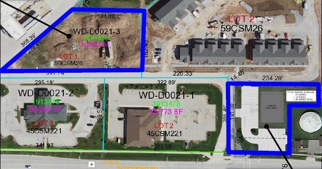
35,172 SQ FT LOT 1 OF 61 CSM 14 MAP 8595 IN 2720224 BNG PRT OF SE1/4 SW1/4 SEC 29 T23N R20E
WD-D0021-4
BROWN
Commercialnec
Wisconsin
B and X Area of moderate flood hazard, usually the area between the limits of the 100-year and 500-year floods.
1
2025
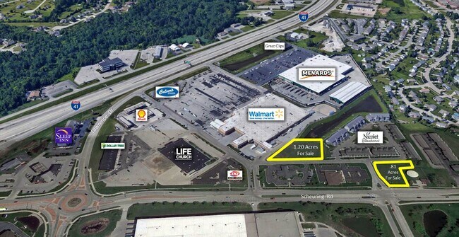
0.81 AC
2025
Ashwaubenon
010202
Green Bay
NEARBY LISTINGS FOR SALE OR LEASE
DEMOGRAPHICS near 1360 Scheuring Rd
1 mile
3 mile
5 mile
2024 Total Population
4,134
33,026
68,821
2029 Population
4,180
33,793
70,291
Pop Growth 2024-2029
+ 1.11%
+ 2.32%
+ 2.14%
Average Age
39
39
40
2024 Total Households
1,663
13,273
28,151
HH Growth 2024-2029
+ 1.14%
+ 2.45%
+ 2.21%
Median Household Inc
$79,655
$86,341
$90,770
Avg Household Size
2.40
2.30
2.30
2024 Avg HH Vehicles
2.00
2.00
2.00
Median Home Value
$269,565
$323,641
$310,168
Median Year Built
1987
1994
1987
Nearby Places
Map Layers
Map Styles
 Street
 Aerial
Transit
 Traffic
 Biking
Places
Listings with unknown addresses are not visible on the map
- Restaurants
- Banks
- Shops
- Fitness
- Groceries
PUBLIC TRANSPORTATION
AIRPORT
Green Bay/Austin Straubel International
Drive
Walk
Distance
Green Bay/Austin Straubel International
12 min
6.2 mi
Appleton International
Drive
Walk
Distance
Appleton International
37 min
29.5 mi
SALE & LEASE HISTORY
LISTING DATE
SALE/LEASE

May 10, 2017
For Sale
Jul 17, 2017
For Sale
Nearby Properties
Address
Land Use
TOTAL SIZE
Lot Size
Zoning
Address
Land Use
TOTAL SIZE
Lot Size
Zoning
11.89 AC
Address
Land Use
TOTAL SIZE
Lot Size
Zoning
1,108,080 SF
76.76 AC
Address
Land Use
TOTAL SIZE
Lot Size
Zoning
55.96 AC
Address
Land Use
TOTAL SIZE
Lot Size
Zoning
452,950 SF
34.59 AC
Address
Land Use
TOTAL SIZE
Lot Size
Zoning
175,271 SF
17.86 AC
Address
Land Use
TOTAL SIZE
Lot Size
Zoning
25.31 AC
Address
Land Use
TOTAL SIZE
Lot Size
Zoning
487,996 SF
23.04 AC
Address
Land Use
TOTAL SIZE
Lot Size
Zoning
20.53 AC
Address
Land Use
TOTAL SIZE
Lot Size
Zoning
71.85 AC
Address
Land Use
TOTAL SIZE
Lot Size
Zoning
35.24 AC
Address
Land Use
TOTAL SIZE
Lot Size
Zoning
339,679 SF
56.88 AC
Address
Land Use
TOTAL SIZE
Lot Size
Zoning
53.92 AC
Address
Land Use
TOTAL SIZE
Lot Size
Zoning
15.61 AC
Address
Land Use
TOTAL SIZE
Lot Size
Zoning
240,000 SF
12.56 AC
Address
Land Use
TOTAL SIZE
Lot Size
Zoning
98,000 SF
10.84 AC
Address
Land Use
TOTAL SIZE
Lot Size
Zoning
26.42 AC
Address
Land Use
TOTAL SIZE
Lot Size
Zoning
37.22 AC
Address
Land Use
TOTAL SIZE
Lot Size
Zoning
174,436 SF
12.23 AC
Address
Land Use
TOTAL SIZE
Lot Size
Zoning
200,000 SF
15.27 AC
Address
Land Use
TOTAL SIZE
Lot Size
Zoning
43.27 AC
Address
Land Use
TOTAL SIZE
Lot Size
Zoning
189,186 SF
17.54 AC
Address
Land Use
TOTAL SIZE
Lot Size
Zoning
14.02 AC
Address
Land Use
TOTAL SIZE
Lot Size
Zoning
156,284 SF
13.76 AC
Address
Land Use
TOTAL SIZE
Lot Size
Zoning
19.59 AC
Address
Land Use
TOTAL SIZE
Lot Size
Zoning
17.84 AC
Address
Land Use
TOTAL SIZE
Lot Size
Zoning
245,300 SF
17.28 AC
Address
Land Use
TOTAL SIZE
Lot Size
Zoning
13.10 AC
Address
Land Use
TOTAL SIZE
Lot Size
Zoning
20.05 AC
Address
Land Use
TOTAL SIZE
Lot Size
Zoning
200,000 SF
12.34 AC
Address
Land Use
TOTAL SIZE
Lot Size
Zoning
10.06 AC
The World's #1 Commercial Real Estate Marketplace
Connect with us
© 2026 CoStar Group
The information above has been obtained from sources believed reliable. While we do not doubt its accuracy we have not verified it and make no guarantee, warranty or representation about it. It is your responsibility to independently confirm its accuracy and completeness. Any projections, opinions, assumptions, or estimates used are for example only and do not represent the current or future performance of the property. The value of this transaction to you depends on tax and other factors which should be evaluated by your tax, financial, and legal advisors. You and your advisors should conduct a careful, independent investigation of the property to determine to your satisfaction the suitability of the property for your needs.