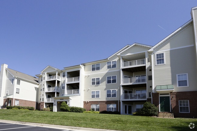
Property Record
13600 Legacy Cir, Herndon, VA 20171

NEARBY LISTINGS FOR SALE OR LEASE
-
-
View all Herndon listings for sale on LoopNet.com
Property Detail
13600 Legacy Cir
Washington-Arlington-Alexandria, DC-VA-MD-WV
Part Of Prop Of Wnb Corp
0154-01-0022E
PART OF PROP OF WNB CORP PCL B
Apartment
Fairfax
X
Virginia
51107C0385E
22e
2024
15.49 AC
2025
Reston
482507
Washington, DC
423,347 SF
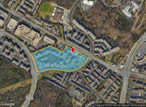
DEMOGRAPHICS near 13600 Legacy Cir
1 Mile
3 Mile
5 Mile
2024 Total Population
22,144
87,934
223,359
2029 Population
22,141
87,380
224,474
Pop Growth 2024-2029
(0.01%)
(0.63%)
+ 0.50%
Average Age
34
37
38
2024 Total Households
8,985
30,790
81,468
HH Growth 2024-2029
+ 0.48%
(0.41%)
+ 0.44%
Median Household Inc
$116,788
$132,766
$135,194
Avg Household Size
2.40
2.80
2.70
2024 Avg HH Vehicles
2.00
2.00
2.00
Median Home Value
$580,310
$642,009
$624,410
Median Year Built
2002
1992
1987
Nearby Places
Map Layers
Map Styles
 Street
 Aerial
- Restaurants
- Banks
- Shops
- Fitness
- Groceries
PUBLIC TRANSPORTATION
AIRPORT
Washington Dulles International
DRIVE
WALK
Distance
Washington Dulles International
12 min
4.6 mi
Ronald Reagan Washington Ntl
DRIVE
WALK
Distance
Ronald Reagan Washington Ntl
41 min
26.7 mi
Freight Ports
Port of Baltimore
DRIVE
WALK
Distance
Port of Baltimore
81 min
58.8 mi
Nearby Properties
Address
Land Use
TOTAL SIZE
Lot Size
Zoning
Address
Land Use
TOTAL SIZE
Lot Size
Zoning
2,700,000 SF
7.51 AC
PDGI
Address
Land Use
TOTAL SIZE
Lot Size
Zoning
760,000 SF
2,461.49 AC
110
Address
Land Use
TOTAL SIZE
Lot Size
Zoning
1,030,157 SF
47.95 AC
550
Address
Land Use
TOTAL SIZE
Lot Size
Zoning
147,260 SF
33.04 AC
PDIP
Address
Land Use
TOTAL SIZE
Lot Size
Zoning
764,166 SF
73.90 AC
PDIP
Address
Land Use
TOTAL SIZE
Lot Size
Zoning
473,458 SF
13.74 AC
540
Address
Land Use
TOTAL SIZE
Lot Size
Zoning
226,456 SF
17.09 AC
PDIP
Address
Land Use
TOTAL SIZE
Lot Size
Zoning
1,096,572 SF
85.06 AC
110
Address
Land Use
TOTAL SIZE
Lot Size
Zoning
120,240 SF
12.15 AC
PDIP
Address
Land Use
TOTAL SIZE
Lot Size
Zoning
128,500 SF
9.95 AC
PDIP
Address
Land Use
TOTAL SIZE
Lot Size
Zoning
520,500 SF
7.29 AC
400
Address
Land Use
TOTAL SIZE
Lot Size
Zoning
332,957 SF
12.68 AC
550
Address
Land Use
TOTAL SIZE
Lot Size
Zoning
425,073 SF
19.02 AC
330
Address
Land Use
TOTAL SIZE
Lot Size
Zoning
357,437 SF
3.76 AC
350
Address
Land Use
TOTAL SIZE
Lot Size
Zoning
429,038 SF
11.41 AC
400
Address
Land Use
TOTAL SIZE
Lot Size
Zoning
396,112 SF
15.92 AC
330
Address
Land Use
TOTAL SIZE
Lot Size
Zoning
490,340 SF
18.30 AC
320
Address
Land Use
TOTAL SIZE
Lot Size
Zoning
306,224 SF
10.14 AC
R1
Address
Land Use
TOTAL SIZE
Lot Size
Zoning
451,000 SF
7.50 AC
550
Address
Land Use
TOTAL SIZE
Lot Size
Zoning
491,841 SF
19.21 AC
320
Address
Land Use
TOTAL SIZE
Lot Size
Zoning
325,000 SF
22.05 AC
550
Address
Land Use
TOTAL SIZE
Lot Size
Zoning
519,708 SF
18.73 AC
316
Address
Land Use
TOTAL SIZE
Lot Size
Zoning
507,264 SF
10.44 AC
400
Address
Land Use
TOTAL SIZE
Lot Size
Zoning
423,718 SF
26.11 AC
596
Address
Land Use
TOTAL SIZE
Lot Size
Zoning
513,947 SF
22.23 AC
400
Address
Land Use
TOTAL SIZE
Lot Size
Zoning
408,315 SF
5.06 AC
400
Address
Land Use
TOTAL SIZE
Lot Size
Zoning
387,620 SF
6.01 AC
350
Address
Land Use
TOTAL SIZE
Lot Size
Zoning
492,219 SF
16.89 AC
330
Address
Land Use
TOTAL SIZE
Lot Size
Zoning
322,205 SF
6.91 AC
330
The World's #1 Commercial Real Estate Marketplace
Connect with us
© 2026 CoStar Group
The information above has been obtained from sources believed reliable. While we do not doubt its accuracy we have not verified it and make no guarantee, warranty or representation about it. It is your responsibility to independently confirm its accuracy and completeness. Any projections, opinions, assumptions, or estimates used are for example only and do not represent the current or future performance of the property. The value of this transaction to you depends on tax and other factors which should be evaluated by your tax, financial, and legal advisors. You and your advisors should conduct a careful, independent investigation of the property to determine to your satisfaction the suitability of the property for your needs.