Property Record
13600 N Interstate 35, Jarrell, TX 76537
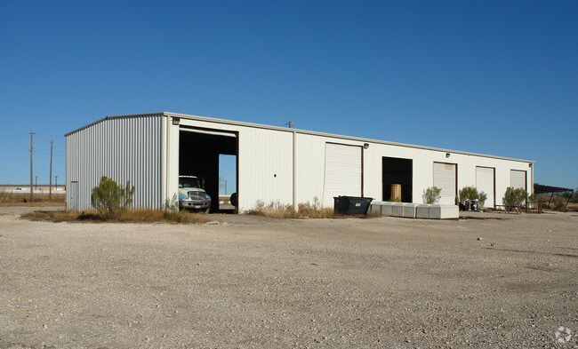

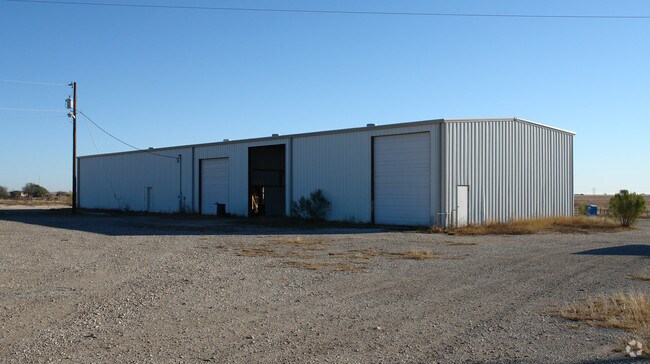
Property Detail
13600 N Interstate 35
R011893
AW0054 BUNKER, I. SUR., ACRES 12.0
Commercialnec
WILLIAMSON
B and X Area of moderate flood hazard, usually the area between the limits of the 100-year and 500-year floods.
Texas
2024
12 AC
2025
Georgetown
021603
Austin
10,000 SF
Austin-Round Rock-San Marcos, TX
NEARBY LISTINGS FOR SALE OR LEASE
-
-
View all Jarrell listings for sale on LoopNet.com
DEMOGRAPHICS near 13600 N Interstate 35
1 mile
3 mile
5 mile
2025 Total Population
1,821
18,466
21,083
2030 Population
2,252
22,007
25,179
Pop Growth 2025-2030
+ 23.67%
+ 19.18%
+ 19.43%
Average Age
39
36
36
2025 Total Households
642
6,348
7,267
HH Growth 2025-2030
+ 23.99%
+ 19.68%
+ 19.93%
Median Household Inc
$82,589
$90,620
$90,837
Avg Household Size
2.80
2.90
2.90
2025 Avg HH Vehicles
2.00
2.00
2.00
Median Home Value
$409,036
$319,201
$328,956
Median Year Built
2011
2011
2011
Nearby Places
Map Layers
Map Styles
 Street
 Aerial
Transit
 Traffic
 Biking
Places
Listings with unknown addresses are not visible on the map
- Restaurants
- Banks
- Shops
- Fitness
- Groceries
PUBLIC TRANSPORTATION
AIRPORT
Killeen Municipal
Drive
Walk
Distance
Killeen Municipal
38 min
26.6 mi
Robert Gray AAF
Drive
Walk
Distance
Robert Gray AAF
51 min
33.3 mi
Nearby Properties
Address
Land Use
TOTAL SIZE
Lot Size
Zoning
Address
Land Use
TOTAL SIZE
Lot Size
Zoning
19.23 AC
Address
Land Use
TOTAL SIZE
Lot Size
Zoning
253,037 SF
16.36 AC
Address
Land Use
TOTAL SIZE
Lot Size
Zoning
110,565 SF
14.29 AC
Address
Land Use
TOTAL SIZE
Lot Size
Zoning
300,531 SF
15.03 AC
Address
Land Use
TOTAL SIZE
Lot Size
Zoning
57.95 AC
Address
Land Use
TOTAL SIZE
Lot Size
Zoning
55.78 AC
Address
Land Use
TOTAL SIZE
Lot Size
Zoning
132,200 SF
7.92 AC
Address
Land Use
TOTAL SIZE
Lot Size
Zoning
120,837 SF
8.44 AC
Address
Land Use
TOTAL SIZE
Lot Size
Zoning
98,000 SF
74.75 AC
Address
Land Use
TOTAL SIZE
Lot Size
Zoning
29,000 SF
25 AC
Address
Land Use
TOTAL SIZE
Lot Size
Zoning
15.03 AC
Address
Land Use
TOTAL SIZE
Lot Size
Zoning
1,942 SF
17.40 AC
Address
Land Use
TOTAL SIZE
Lot Size
Zoning
20,414 SF
8.27 AC
Address
Land Use
TOTAL SIZE
Lot Size
Zoning
24,808 SF
49.75 AC
Address
Land Use
TOTAL SIZE
Lot Size
Zoning
58,543 SF
6.74 AC
Address
Land Use
TOTAL SIZE
Lot Size
Zoning
33.99 AC
Address
Land Use
TOTAL SIZE
Lot Size
Zoning
14,297 SF
6.71 AC
Address
Land Use
TOTAL SIZE
Lot Size
Zoning
15,615 SF
2.39 AC
Address
Land Use
TOTAL SIZE
Lot Size
Zoning
68,261 SF
4.12 AC
Address
Land Use
TOTAL SIZE
Lot Size
Zoning
24.75 AC
Address
Land Use
TOTAL SIZE
Lot Size
Zoning
15,525 SF
18.71 AC
Address
Land Use
TOTAL SIZE
Lot Size
Zoning
43,852 SF
3 AC
Address
Land Use
TOTAL SIZE
Lot Size
Zoning
21,844 SF
3.25 AC
Address
Land Use
TOTAL SIZE
Lot Size
Zoning
30,996 SF
12.02 AC
Address
Land Use
TOTAL SIZE
Lot Size
Zoning
17.89 AC
Address
Land Use
TOTAL SIZE
Lot Size
Zoning
20,000 SF
7.90 AC
Address
Land Use
TOTAL SIZE
Lot Size
Zoning
32,220 SF
4 AC
Address
Land Use
TOTAL SIZE
Lot Size
Zoning
16.79 AC
Address
Land Use
TOTAL SIZE
Lot Size
Zoning
25,000 SF
2.99 AC
Address
Land Use
TOTAL SIZE
Lot Size
Zoning
24,668 SF
3.41 AC
The World's #1 Commercial Real Estate Marketplace
Connect with us
© 2026 CoStar Group
The information above has been obtained from sources believed reliable. While we do not doubt its accuracy we have not verified it and make no guarantee, warranty or representation about it. It is your responsibility to independently confirm its accuracy and completeness. Any projections, opinions, assumptions, or estimates used are for example only and do not represent the current or future performance of the property. The value of this transaction to you depends on tax and other factors which should be evaluated by your tax, financial, and legal advisors. You and your advisors should conduct a careful, independent investigation of the property to determine to your satisfaction the suitability of the property for your needs.