Property Record
13601 Se No Address Assigned By City Hwy, Lees Summit, MO 64082
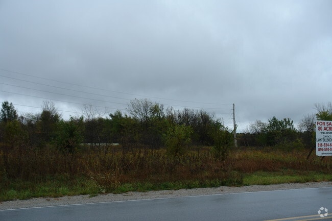
This Property Is For Sale
NEARBY LISTINGS FOR SALE OR LEASE
Property Detail
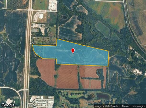
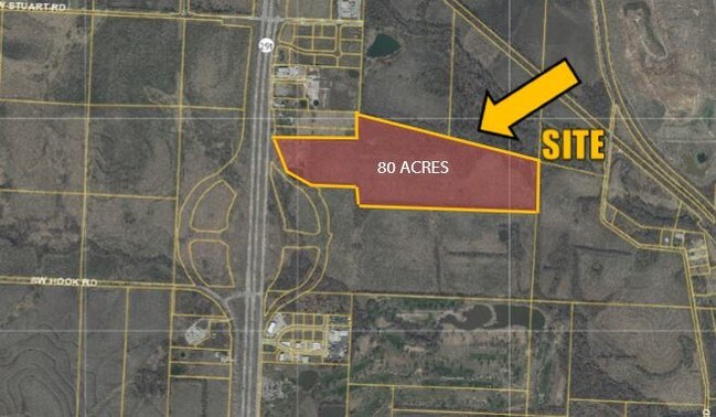
13601 Se No Address Assigned By City Hwy
70-200-04-01-01-0-00-000
SEC-20 TWP-47 RNG-31 BEG AT PT 1318.5 N OF SE COR SE 1/4 TH W 2653.97 MOL TH N 248 MOL TH W 701 MOL TH NWLY 107 MOL TH NWLY 168 MOL TH NWLY 175 MOL TH NWLY 155 MOL TH NWLY
Agriculturalland
Jackson
X
Missouri
29095C0551G
78.69 AC
2024
Southeast Jackson County
2025
Kansas City
018101
Kansas City, MO-KS
DEMOGRAPHICS near 13601 Se No Address Assigned By City Hwy
1 Mile
3 Mile
5 Mile
2024 Total Population
264
39,144
91,451
2029 Population
262
38,957
91,684
Pop Growth 2024-2029
(0.76%)
(0.48%)
+ 0.25%
Average Age
37
39
40
2024 Total Households
95
14,529
34,640
HH Growth 2024-2029
(1.05%)
(0.59%)
+ 0.23%
Median Household Inc
$97,058
$101,090
$102,117
Avg Household Size
2.80
2.70
2.60
2024 Avg HH Vehicles
2.00
2.00
2.00
Median Home Value
$288,094
$274,275
$282,810
Median Year Built
2001
1992
1992
Nearby Places
- Restaurants
- Banks
- Shops
- Fitness
- Groceries
PUBLIC TRANSPORTATION
COMMUTER RAIL
Lee's Summit Amtrak (Lincoln Service Missouri River Runner - Amtrak, Missouri River Runner - Amtrak)
DRIVE
WALK
Distance
Lee's Summit Amtrak (Lincoln Service Missouri River Runner - Amtrak, Missouri River Runner - Amtrak)
6 min
2.9 mi
Freight Ports
Tulsa Port Of Catoosa
DRIVE
WALK
Distance
Tulsa Port Of Catoosa
256 min
235.2 mi
Nearby Properties
Address
Land Use
TOTAL SIZE
Lot Size
Zoning
Address
Land Use
TOTAL SIZE
Lot Size
Zoning
264,963 SF
Address
Land Use
TOTAL SIZE
Lot Size
Zoning
107,210 SF
17.13 AC
Address
Land Use
TOTAL SIZE
Lot Size
Zoning
249,821 SF
87.90 AC
Address
Land Use
TOTAL SIZE
Lot Size
Zoning
100,573 SF
2.89 AC
Address
Land Use
TOTAL SIZE
Lot Size
Zoning
383,280 SF
0.91 AC
Address
Land Use
TOTAL SIZE
Lot Size
Zoning
563,000 SF
40.34 AC
Address
Land Use
TOTAL SIZE
Lot Size
Zoning
281,235 SF
70.15 AC
Address
Land Use
TOTAL SIZE
Lot Size
Zoning
200,526 SF
Address
Land Use
TOTAL SIZE
Lot Size
Zoning
18,509 SF
20.39 AC
Address
Land Use
TOTAL SIZE
Lot Size
Zoning
143,335 SF
Address
Land Use
TOTAL SIZE
Lot Size
Zoning
155,194 SF
21.03 AC
Address
Land Use
TOTAL SIZE
Lot Size
Zoning
36,744 SF
20.20 AC
Address
Land Use
TOTAL SIZE
Lot Size
Zoning
140,194 SF
29.50 AC
Address
Land Use
TOTAL SIZE
Lot Size
Zoning
99,891 SF
9.71 AC
Address
Land Use
TOTAL SIZE
Lot Size
Zoning
65,290 SF
15.70 AC
Address
Land Use
TOTAL SIZE
Lot Size
Zoning
48,764 SF
8.25 AC
Address
Land Use
TOTAL SIZE
Lot Size
Zoning
150,619 SF
19.95 AC
Address
Land Use
TOTAL SIZE
Lot Size
Zoning
74,741 SF
20 AC
Address
Land Use
TOTAL SIZE
Lot Size
Zoning
37,489 SF
9.22 AC
Address
Land Use
TOTAL SIZE
Lot Size
Zoning
118,310 SF
10.55 AC
Address
Land Use
TOTAL SIZE
Lot Size
Zoning
89,962 SF
10.37 AC
Address
Land Use
TOTAL SIZE
Lot Size
Zoning
18,150 SF
Address
Land Use
TOTAL SIZE
Lot Size
Zoning
171,779 SF
11.42 AC
Address
Land Use
TOTAL SIZE
Lot Size
Zoning
30,849 SF
4.99 AC
Address
Land Use
TOTAL SIZE
Lot Size
Zoning
136,620 SF
12.52 AC
Address
Land Use
TOTAL SIZE
Lot Size
Zoning
33,063 SF
17.56 AC
Address
Land Use
TOTAL SIZE
Lot Size
Zoning
18,543 SF
6.59 AC
Address
Land Use
TOTAL SIZE
Lot Size
Zoning
Address
Land Use
TOTAL SIZE
Lot Size
Zoning
41,418 SF
19.79 AC
Address
Land Use
TOTAL SIZE
Lot Size
Zoning
59,334 SF
15.12 AC
The World's #1 Commercial Real Estate Marketplace
Connect with us
© 2025 CoStar Group
The information above has been obtained from sources believed reliable. While we do not doubt its accuracy we have not verified it and make no guarantee, warranty or representation about it. It is your responsibility to independently confirm its accuracy and completeness. Any projections, opinions, assumptions, or estimates used are for example only and do not represent the current or future performance of the property. The value of this transaction to you depends on tax and other factors which should be evaluated by your tax, financial, and legal advisors. You and your advisors should conduct a careful, independent investigation of the property to determine to your satisfaction the suitability of the property for your needs.