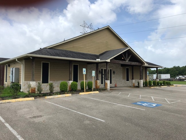
Property Record
13606 Magnolia Pky, Rosharon, TX 77583

NEARBY LISTINGS FOR SALE OR LEASE
Property Detail
13606 Magnolia Pky
0566-0003-000
A C H & B
Commercialnec
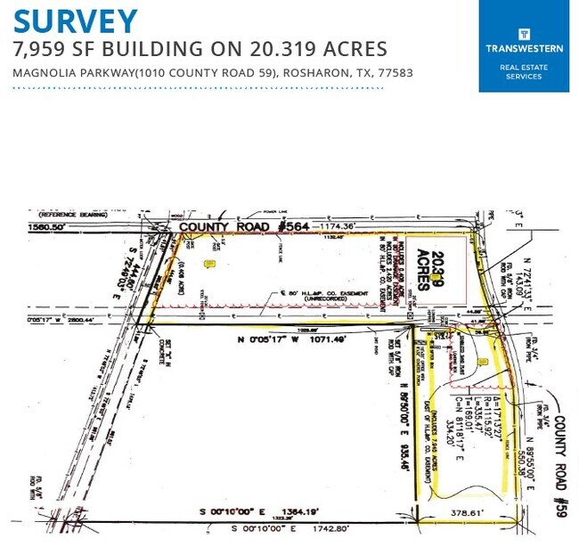
A0566 A C H & B TRACT A1B-1B (MAIN SURVEY) ACRES 20.318
AE
Brazoria
48039C0020K
Texas
2024
20.32 AC
2025
South
6606022
Houston
11,229 SF
Houston-Pasadena-The Woodlands, TX
DEMOGRAPHICS near 13606 Magnolia Pky
1 Mile
3 Mile
5 Mile
2024 Total Population
4,592
78,674
173,922
2029 Population
5,248
90,459
198,770
Pop Growth 2024-2029
+ 14.29%
+ 14.98%
+ 14.29%
Average Age
34
35
35
2024 Total Households
1,381
24,711
55,291
HH Growth 2024-2029
+ 14.70%
+ 15.20%
+ 14.47%
Median Household Inc
$155,973
$104,410
$92,573
Avg Household Size
3.20
3.10
3.10
2024 Avg HH Vehicles
2.00
2.00
2.00
Median Home Value
$354,891
$310,533
$282,791
Median Year Built
2011
2010
2006
Nearby Places
Map Layers
Map Styles
 Street
 Aerial
- Restaurants
- Banks
- Shops
- Fitness
- Groceries
PUBLIC TRANSPORTATION
AIRPORT
William P Hobby
DRIVE
WALK
Distance
William P Hobby
30 min
16.1 mi
Freight Ports
Port of Houston
DRIVE
WALK
Distance
Port of Houston
36 min
22.9 mi
SALE & LEASE HISTORY
LISTING DATE
SALE/LEASE

Oct 03, 2022
For Sale
Jun 26, 2019
For Sale
Jun 17, 2020
For Lease
Nearby Properties
Address
Land Use
TOTAL SIZE
Lot Size
Zoning
Address
Land Use
TOTAL SIZE
Lot Size
Zoning
241,351 SF
60.11 AC
Address
Land Use
TOTAL SIZE
Lot Size
Zoning
367,766 SF
43.71 AC
Address
Land Use
TOTAL SIZE
Lot Size
Zoning
679,822 SF
27.54 AC
Address
Land Use
TOTAL SIZE
Lot Size
Zoning
369,539 SF
30.71 AC
Address
Land Use
TOTAL SIZE
Lot Size
Zoning
372,209 SF
17.91 AC
Address
Land Use
TOTAL SIZE
Lot Size
Zoning
460,711 SF
18.98 AC
Address
Land Use
TOTAL SIZE
Lot Size
Zoning
373,654 SF
16.35 AC
Address
Land Use
TOTAL SIZE
Lot Size
Zoning
372,280 SF
14.70 AC
0021
Address
Land Use
TOTAL SIZE
Lot Size
Zoning
447,956 SF
18.42 AC
Address
Land Use
TOTAL SIZE
Lot Size
Zoning
412,375 SF
22.57 AC
Address
Land Use
TOTAL SIZE
Lot Size
Zoning
156,214 SF
13.50 AC
0025
Address
Land Use
TOTAL SIZE
Lot Size
Zoning
319,173 SF
7.67 AC
Address
Land Use
TOTAL SIZE
Lot Size
Zoning
281,889 SF
10.84 AC
Address
Land Use
TOTAL SIZE
Lot Size
Zoning
323,168 SF
12.80 AC
Address
Land Use
TOTAL SIZE
Lot Size
Zoning
379,493 SF
14.27 AC
Address
Land Use
TOTAL SIZE
Lot Size
Zoning
66,998 SF
11.34 AC
Address
Land Use
TOTAL SIZE
Lot Size
Zoning
215,063 SF
19.13 AC
Address
Land Use
TOTAL SIZE
Lot Size
Zoning
228,276 SF
9.43 AC
0036
Address
Land Use
TOTAL SIZE
Lot Size
Zoning
117,729 SF
15.41 AC
Address
Land Use
TOTAL SIZE
Lot Size
Zoning
172,256 SF
6.13 AC
Address
Land Use
TOTAL SIZE
Lot Size
Zoning
289,955 SF
11.96 AC
Address
Land Use
TOTAL SIZE
Lot Size
Zoning
66,060 SF
12.85 AC
0016
Address
Land Use
TOTAL SIZE
Lot Size
Zoning
107,915 SF
9.29 AC
Address
Land Use
TOTAL SIZE
Lot Size
Zoning
58,985 SF
4.34 AC
Address
Land Use
TOTAL SIZE
Lot Size
Zoning
82,400 SF
10.85 AC
I
Address
Land Use
TOTAL SIZE
Lot Size
Zoning
103,316 SF
Address
Land Use
TOTAL SIZE
Lot Size
Zoning
152,722 SF
16.70 AC
Address
Land Use
TOTAL SIZE
Lot Size
Zoning
59,618 SF
4.50 AC
Address
Land Use
TOTAL SIZE
Lot Size
Zoning
49,404 SF
1.90 AC
Address
Land Use
TOTAL SIZE
Lot Size
Zoning
77,272 SF
The World's #1 Commercial Real Estate Marketplace
Connect with us
© 2026 CoStar Group
The information above has been obtained from sources believed reliable. While we do not doubt its accuracy we have not verified it and make no guarantee, warranty or representation about it. It is your responsibility to independently confirm its accuracy and completeness. Any projections, opinions, assumptions, or estimates used are for example only and do not represent the current or future performance of the property. The value of this transaction to you depends on tax and other factors which should be evaluated by your tax, financial, and legal advisors. You and your advisors should conduct a careful, independent investigation of the property to determine to your satisfaction the suitability of the property for your needs.