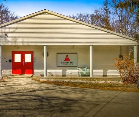
Property Record
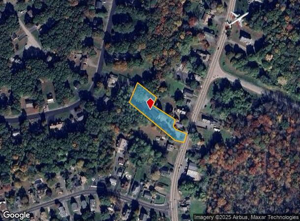
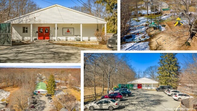
1361 Somerset Ave, Taunton, MA 02780

NEARBY LISTINGS FOR SALE OR LEASE
Property Detail
1361 Somerset Ave
TAUN-000115-000217
Bristol
Daycare
Massachusetts
X
217
25005C0251G
0.87 AC
2025
Attleboro/New Bedford
2025
Boston
613902
Providence-Warwick, RI-MA
5,664 SF
DEMOGRAPHICS near 1361 Somerset Ave
1 Mile
3 Mile
5 Mile
2024 Total Population
2,966
34,009
69,559
2029 Population
2,917
33,688
68,907
Pop Growth 2024-2029
(1.65%)
(0.94%)
(0.94%)
Average Age
41
40
41
2024 Total Households
1,103
13,579
27,108
HH Growth 2024-2029
(1.72%)
(0.96%)
(0.99%)
Median Household Inc
$92,588
$62,259
$72,814
Avg Household Size
2.60
2.40
2.50
2024 Avg HH Vehicles
2.00
2.00
2.00
Median Home Value
$369,329
$367,211
$375,082
Median Year Built
1981
1964
1969
Nearby Places
Map Layers
Map Styles
 Street
 Aerial
- Restaurants
- Banks
- Shops
- Fitness
- Groceries
PUBLIC TRANSPORTATION
AIRPORT
Rhode Island Tf Green International
DRIVE
WALK
Distance
Rhode Island Tf Green International
44 min
25.2 mi
Freight Ports
Port of New Bedford Harbor
DRIVE
WALK
Distance
Port of New Bedford Harbor
35 min
24.4 mi
SALE & LEASE HISTORY
LISTING DATE
SALE/LEASE

Mar 26, 2021
For Sale
Aug 17, 2020
For Sale
Nearby Properties
Address
Land Use
TOTAL SIZE
Lot Size
Zoning
Address
Land Use
TOTAL SIZE
Lot Size
Zoning
279,756 SF
11.62 AC
OFFDIS
Address
Land Use
TOTAL SIZE
Lot Size
Zoning
130,851 SF
24.43 AC
URBRES
Address
Land Use
TOTAL SIZE
Lot Size
Zoning
147,285 SF
0.79 AC
CENBIZ
Address
Land Use
TOTAL SIZE
Lot Size
Zoning
174,000 SF
62.88 AC
R1
Address
Land Use
TOTAL SIZE
Lot Size
Zoning
37.62 AC
URBRES
Address
Land Use
TOTAL SIZE
Lot Size
Zoning
39,910 SF
1.05 AC
CENBIZ
Address
Land Use
TOTAL SIZE
Lot Size
Zoning
351,320 SF
42 AC
INDUST
Address
Land Use
TOTAL SIZE
Lot Size
Zoning
5.20 AC
URBRES
Address
Land Use
TOTAL SIZE
Lot Size
Zoning
52,042 SF
59.53 AC
OPSPAC
Address
Land Use
TOTAL SIZE
Lot Size
Zoning
127,092 SF
9.37 AC
INDUST
Address
Land Use
TOTAL SIZE
Lot Size
Zoning
6.53 AC
URBRES
Address
Land Use
TOTAL SIZE
Lot Size
Zoning
45,786 SF
16 AC
URBRES
Address
Land Use
TOTAL SIZE
Lot Size
Zoning
76,960 SF
23.40 AC
C
Address
Land Use
TOTAL SIZE
Lot Size
Zoning
16 AC
URBRES
Address
Land Use
TOTAL SIZE
Lot Size
Zoning
124,465 SF
15.08 AC
INDUST
Address
Land Use
TOTAL SIZE
Lot Size
Zoning
44,581 SF
14.60 AC
RURRES
Address
Land Use
TOTAL SIZE
Lot Size
Zoning
61,128 SF
0.98 AC
Address
Land Use
TOTAL SIZE
Lot Size
Zoning
13 AC
HIWABZ
Address
Land Use
TOTAL SIZE
Lot Size
Zoning
108,692 SF
10.80 AC
R1
Address
Land Use
TOTAL SIZE
Lot Size
Zoning
3 AC
URBRES
Address
Land Use
TOTAL SIZE
Lot Size
Zoning
5.60 AC
INDUST
Address
Land Use
TOTAL SIZE
Lot Size
Zoning
24 AC
HIWABZ
Address
Land Use
TOTAL SIZE
Lot Size
Zoning
86,176 SF
7.14 AC
INDUST
Address
Land Use
TOTAL SIZE
Lot Size
Zoning
12.38 AC
INDUST
Address
Land Use
TOTAL SIZE
Lot Size
Zoning
164,658 SF
15.18 AC
BIZDIS
Address
Land Use
TOTAL SIZE
Lot Size
Zoning
29,400 SF
12.91 AC
I
Address
Land Use
TOTAL SIZE
Lot Size
Zoning
11.82 AC
URBRES
Address
Land Use
TOTAL SIZE
Lot Size
Zoning
4.53 AC
URBRES
Address
Land Use
TOTAL SIZE
Lot Size
Zoning
38,422 SF
0.82 AC
OFFDIS
Address
Land Use
TOTAL SIZE
Lot Size
Zoning
244,320 SF
13.66 AC
INDUST
The World's #1 Commercial Real Estate Marketplace
Connect with us
© 2025 CoStar Group
The information above has been obtained from sources believed reliable. While we do not doubt its accuracy we have not verified it and make no guarantee, warranty or representation about it. It is your responsibility to independently confirm its accuracy and completeness. Any projections, opinions, assumptions, or estimates used are for example only and do not represent the current or future performance of the property. The value of this transaction to you depends on tax and other factors which should be evaluated by your tax, financial, and legal advisors. You and your advisors should conduct a careful, independent investigation of the property to determine to your satisfaction the suitability of the property for your needs.