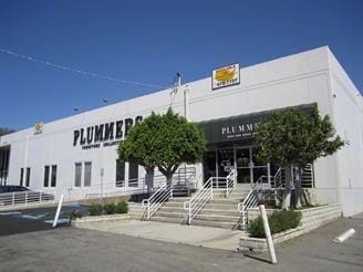
Property Record
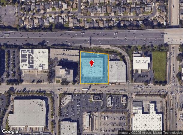
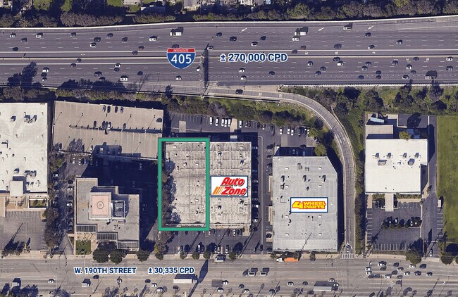
1361 W 190Th St, Gardena, CA 90248

Current Lease Availabilities
NEARBY LISTINGS FOR SALE OR LEASE
Property Detail
1361 W 190Th St
Los Angeles-Long Beach-Glendale, CA
Mcdonald Tract San Pedro Rancho
7351-001-020
MCDONALD TRACT SAN PEDRO RANCHO LOT COM AT INTERSECTION OF N LINE OF 190 TH ST WITH W LINE OF LOT 104 TH E ON SD N LINE 301.12 FT TH N TO S LINE OF SAN DIEGO FREEWAY TH W THEREON TO SD W LINE TH S TO BEG PART OF LOT 104
Storemultistory
Los Angeles
X
California
06037C1935F
104
2024
2.32 AC
2025
190th Street Corridor
292001
Los Angeles
50,250 SF
DEMOGRAPHICS near 1361 W 190Th St
1 Mile
3 Mile
5 Mile
2024 Total Population
9,830
199,828
623,298
2029 Population
9,489
193,524
604,155
Pop Growth 2024-2029
(3.47%)
(3.15%)
(3.07%)
Average Age
43
42
40
2024 Total Households
3,524
67,105
206,720
HH Growth 2024-2029
(3.75%)
(3.42%)
(3.27%)
Median Household Inc
$88,699
$83,005
$85,864
Avg Household Size
2.70
2.80
2.90
2024 Avg HH Vehicles
2.00
2.00
2.00
Median Home Value
$719,137
$714,977
$744,888
Median Year Built
1958
1963
1964
Nearby Places
Map Layers
Map Styles
 Street
 Aerial
- Restaurants
- Banks
- Shops
- Fitness
- Groceries
PUBLIC TRANSPORTATION
AIRPORT
Long Beach (Daugherty Field)
DRIVE
WALK
Distance
Long Beach (Daugherty Field)
15 min
9.7 mi
Los Angeles International
DRIVE
WALK
Distance
Los Angeles International
17 min
11.1 mi
John Wayne/Orange County
DRIVE
WALK
Distance
John Wayne/Orange County
37 min
30.0 mi
Freight Ports
Port of Long Beach
DRIVE
WALK
Distance
Port of Long Beach
17 min
11.6 mi
Nearby Properties
Address
Land Use
TOTAL SIZE
Lot Size
Zoning
Address
Land Use
TOTAL SIZE
Lot Size
Zoning
997,143 SF
98.35 AC
TOMI-BP
Address
Land Use
TOTAL SIZE
Lot Size
Zoning
64,456 SF
11.71 AC
CASP-10*
Address
Land Use
TOTAL SIZE
Lot Size
Zoning
10,152 SF
140.14 AC
TOMI-HVY
Address
Land Use
TOTAL SIZE
Lot Size
Zoning
422,640 SF
LAM3
Address
Land Use
TOTAL SIZE
Lot Size
Zoning
321,011 SF
15.06 AC
TOMI-LT
Address
Land Use
TOTAL SIZE
Lot Size
Zoning
291,731 SF
16.84 AC
CAML*
Address
Land Use
TOTAL SIZE
Lot Size
Zoning
604,106 SF
42.72 AC
TOMI-HVY
Address
Land Use
TOTAL SIZE
Lot Size
Zoning
506,189 SF
20.33 AC
LAM2
Address
Land Use
TOTAL SIZE
Lot Size
Zoning
3,585,714 SF
67.35 AC
LAM3
Address
Land Use
TOTAL SIZE
Lot Size
Zoning
409,522 SF
11.41 AC
LAM3
Address
Land Use
TOTAL SIZE
Lot Size
Zoning
184,300 SF
8.14 AC
LAM3
Address
Land Use
TOTAL SIZE
Lot Size
Zoning
214,782 SF
3.66 AC
GAR3
Address
Land Use
TOTAL SIZE
Lot Size
Zoning
103,228 SF
1.19 AC
TORR-HI
Address
Land Use
TOTAL SIZE
Lot Size
Zoning
260,766 SF
10.70 AC
LAM3
Address
Land Use
TOTAL SIZE
Lot Size
Zoning
502,236 SF
11.58 AC
TOMI-LT
Address
Land Use
TOTAL SIZE
Lot Size
Zoning
429,141 SF
3.29 AC
LCM1*
Address
Land Use
TOTAL SIZE
Lot Size
Zoning
282,280 SF
Address
Land Use
TOTAL SIZE
Lot Size
Zoning
670,305 SF
28.08 AC
TOMI-BP
Address
Land Use
TOTAL SIZE
Lot Size
Zoning
198,502 SF
LCM2 *
Address
Land Use
TOTAL SIZE
Lot Size
Zoning
308,439 SF
19.05 AC
TOHC-GEN
Address
Land Use
TOTAL SIZE
Lot Size
Zoning
365,701 SF
2.45 AC
TOMI-BP
Address
Land Use
TOTAL SIZE
Lot Size
Zoning
1.27 AC
CACR&D*
Address
Land Use
TOTAL SIZE
Lot Size
Zoning
125,849 SF
6.08 AC
LAM2
Address
Land Use
TOTAL SIZE
Lot Size
Zoning
24,060 SF
LAM2
Address
Land Use
TOTAL SIZE
Lot Size
Zoning
178,323 SF
12.23 AC
CACR&D&MUR
Address
Land Use
TOTAL SIZE
Lot Size
Zoning
546,606 SF
17.58 AC
LAM3
Address
Land Use
TOTAL SIZE
Lot Size
Zoning
1,005,037 SF
23.98 AC
TOMI-LT
Address
Land Use
TOTAL SIZE
Lot Size
Zoning
155,099 SF
7.74 AC
TOMI-HVY
Address
Land Use
TOTAL SIZE
Lot Size
Zoning
383,794 SF
10.74 AC
TOMI-LT
Address
Land Use
TOTAL SIZE
Lot Size
Zoning
169,576 SF
8.40 AC
TOMI-BP
The World's #1 Commercial Real Estate Marketplace
Connect with us
© 2025 CoStar Group
The information above has been obtained from sources believed reliable. While we do not doubt its accuracy we have not verified it and make no guarantee, warranty or representation about it. It is your responsibility to independently confirm its accuracy and completeness. Any projections, opinions, assumptions, or estimates used are for example only and do not represent the current or future performance of the property. The value of this transaction to you depends on tax and other factors which should be evaluated by your tax, financial, and legal advisors. You and your advisors should conduct a careful, independent investigation of the property to determine to your satisfaction the suitability of the property for your needs.