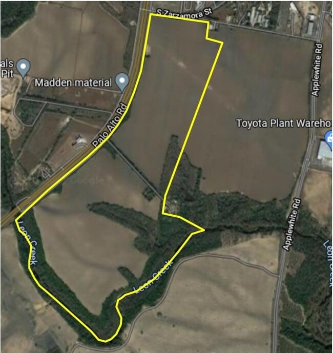
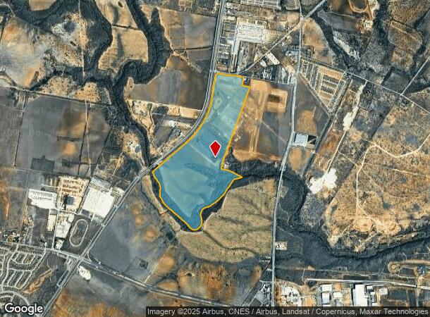
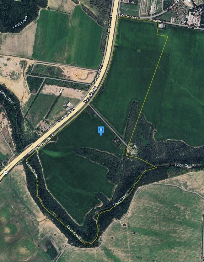
Property Record
13610 State Highway 16 S, San Antonio, TX 78224
NEARBY LISTINGS FOR SALE OR LEASE
-
-
-
-
-
-
-
-
-
Loop 410 @ S Zarzamora St & Pleasanton Rd
San Antonio, TX 78221
Rent Upon Request
29.45 - 590.87 AC Lot
Land
-
-
View all San Antonio listings for sale on LoopNet.com
Property Detail
13610 State Highway 16 S
San Antonio-New Braunfels, TX
Conv A/S Code
04005-000-0138
CB 4005 P-13E ABS 15 (SOUTHSIDE STUDY AREA 3 ANNEXATION) ORDINANCE# 2007-101605/ADD TU21
Heavyindustrial
Bexar
AE
Texas
48029C0570F
138
2024
227.28 AC
2025
South
152000
San Antonio
865,757 SF
DEMOGRAPHICS near 13610 State Highway 16 S
1 Mile
3 Mile
5 Mile
2024 Total Population
1,041
15,991
67,802
2029 Population
1,140
17,763
72,763
Pop Growth 2024-2029
+ 9.51%
+ 11.08%
+ 7.32%
Average Age
29
33
35
2024 Total Households
272
4,652
20,531
HH Growth 2024-2029
+ 10.29%
+ 11.46%
+ 7.55%
Median Household Inc
$52,333
$54,884
$51,219
Avg Household Size
3.20
3.30
3.20
2024 Avg HH Vehicles
2.00
2.00
2.00
Median Home Value
$180,882
$162,962
$147,264
Median Year Built
2007
2005
1988
Nearby Places
Map Layers
Map Styles
 Street
 Aerial
- Restaurants
- Banks
- Shops
- Fitness
- Groceries
PUBLIC TRANSPORTATION
AIRPORT
San Antonio International
DRIVE
WALK
Distance
San Antonio International
28 min
19.0 mi
Freight Ports
Port of Corpus Christi
DRIVE
WALK
Distance
Port of Corpus Christi
151 min
145.4 mi
SALE & LEASE HISTORY
LISTING DATE
SALE/LEASE

Sep 29, 2021
For Sale
Nearby Properties
Address
Land Use
TOTAL SIZE
Lot Size
Zoning
Address
Land Use
TOTAL SIZE
Lot Size
Zoning
5,370,988 SF
1,995.73 AC
Address
Land Use
TOTAL SIZE
Lot Size
Zoning
850,200 SF
88.05 AC
Address
Land Use
TOTAL SIZE
Lot Size
Zoning
388,205 SF
9.74 AC
Address
Land Use
TOTAL SIZE
Lot Size
Zoning
391,830 SF
18.02 AC
Address
Land Use
TOTAL SIZE
Lot Size
Zoning
96 SF
46.96 AC
Address
Land Use
TOTAL SIZE
Lot Size
Zoning
324,153 SF
17.31 AC
Address
Land Use
TOTAL SIZE
Lot Size
Zoning
386,156 SF
10.50 AC
Address
Land Use
TOTAL SIZE
Lot Size
Zoning
504,337 SF
45.55 AC
Address
Land Use
TOTAL SIZE
Lot Size
Zoning
348,707 SF
9.90 AC
Address
Land Use
TOTAL SIZE
Lot Size
Zoning
291,460 SF
9.48 AC
Address
Land Use
TOTAL SIZE
Lot Size
Zoning
329,893 SF
11.59 AC
Address
Land Use
TOTAL SIZE
Lot Size
Zoning
152,174 SF
Address
Land Use
TOTAL SIZE
Lot Size
Zoning
1,269.46 AC
Address
Land Use
TOTAL SIZE
Lot Size
Zoning
526.61 AC
Address
Land Use
TOTAL SIZE
Lot Size
Zoning
182,736 SF
16.49 AC
Address
Land Use
TOTAL SIZE
Lot Size
Zoning
590.88 AC
Address
Land Use
TOTAL SIZE
Lot Size
Zoning
116,964 SF
15.07 AC
Address
Land Use
TOTAL SIZE
Lot Size
Zoning
170,679 SF
11.42 AC
Address
Land Use
TOTAL SIZE
Lot Size
Zoning
Address
Land Use
TOTAL SIZE
Lot Size
Zoning
80,652 SF
11.77 AC
Address
Land Use
TOTAL SIZE
Lot Size
Zoning
80,640 SF
6 AC
Address
Land Use
TOTAL SIZE
Lot Size
Zoning
99,350 SF
2.44 AC
Address
Land Use
TOTAL SIZE
Lot Size
Zoning
336,932 SF
17.01 AC
Address
Land Use
TOTAL SIZE
Lot Size
Zoning
Address
Land Use
TOTAL SIZE
Lot Size
Zoning
864 SF
284.29 AC
Address
Land Use
TOTAL SIZE
Lot Size
Zoning
69,575 SF
7.72 AC
Address
Land Use
TOTAL SIZE
Lot Size
Zoning
70,255 SF
3.02 AC
Address
Land Use
TOTAL SIZE
Lot Size
Zoning
235,275 SF
2.92 AC
Address
Land Use
TOTAL SIZE
Lot Size
Zoning
79,000 SF
5.91 AC
Address
Land Use
TOTAL SIZE
Lot Size
Zoning
76,638 SF
7.56 AC
The World's #1 Commercial Real Estate Marketplace
Connect with us
© 2026 CoStar Group
The information above has been obtained from sources believed reliable. While we do not doubt its accuracy we have not verified it and make no guarantee, warranty or representation about it. It is your responsibility to independently confirm its accuracy and completeness. Any projections, opinions, assumptions, or estimates used are for example only and do not represent the current or future performance of the property. The value of this transaction to you depends on tax and other factors which should be evaluated by your tax, financial, and legal advisors. You and your advisors should conduct a careful, independent investigation of the property to determine to your satisfaction the suitability of the property for your needs.