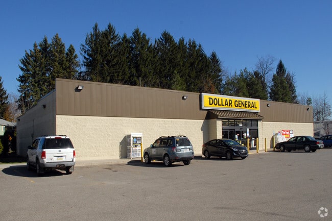
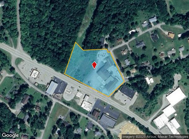
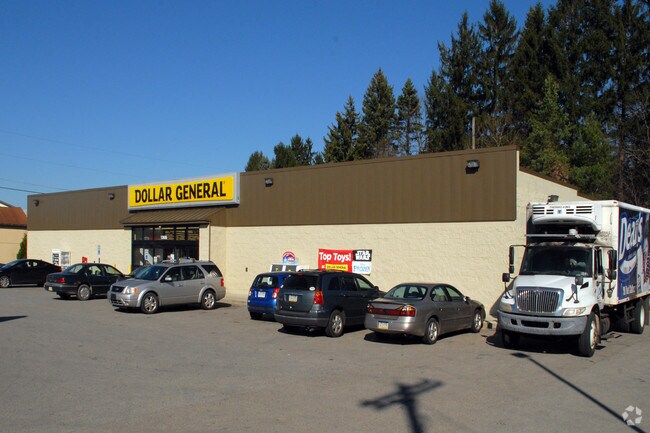
Property Record
13610 State Route 422, Kittanning, PA 16201
NEARBY LISTINGS FOR SALE OR LEASE
Property Detail
13610 State Route 422
29-0-067619
MAP NO:131.10-01-63; LOT 1 - IMPRS. PB6 PG349 SL592
Storebuilding
Armstrong
X
Pennsylvania
42005C0336D
1
2025
3.97 AC
2025
Armstrong County
950900
Pittsburgh
7,069 SF
Pittsburgh, PA
DEMOGRAPHICS near 13610 State Route 422
1 Mile
3 Mile
5 Mile
2024 Total Population
845
11,931
19,814
2029 Population
827
11,745
19,509
Pop Growth 2024-2029
(2.13%)
(1.56%)
(1.54%)
Average Age
44
44
45
2024 Total Households
351
5,308
8,788
HH Growth 2024-2029
(1.99%)
(1.51%)
(1.50%)
Median Household Inc
$51,428
$49,816
$54,237
Avg Household Size
2.30
2.20
2.20
2024 Avg HH Vehicles
2.00
2.00
2.00
Median Home Value
$126,351
$115,546
$123,795
Median Year Built
1954
1953
1955
Nearby Places
Map Layers
Map Styles
 Street
 Aerial
- Restaurants
- Banks
- Shops
- Fitness
- Groceries
Nearby Properties
Address
Land Use
TOTAL SIZE
Lot Size
Zoning
Address
Land Use
TOTAL SIZE
Lot Size
Zoning
260,664 SF
68 AC
Address
Land Use
TOTAL SIZE
Lot Size
Zoning
145,792 SF
13.04 AC
COMMERCIAL
Address
Land Use
TOTAL SIZE
Lot Size
Zoning
75,000 SF
121.87 AC
Address
Land Use
TOTAL SIZE
Lot Size
Zoning
31,984 SF
0.79 AC
BUSINESS
Address
Land Use
TOTAL SIZE
Lot Size
Zoning
27,200 SF
5.99 AC
INDUSTRIAL
Address
Land Use
TOTAL SIZE
Lot Size
Zoning
96,646 SF
7.90 AC
COMMERCIAL
Address
Land Use
TOTAL SIZE
Lot Size
Zoning
113,651 SF
4.49 AC
Address
Land Use
TOTAL SIZE
Lot Size
Zoning
42,238 SF
1.50 AC
PUBLIC
Address
Land Use
TOTAL SIZE
Lot Size
Zoning
31,290 SF
2.93 AC
COMMERCIAL
Address
Land Use
TOTAL SIZE
Lot Size
Zoning
89,326 SF
1.01 AC
PUBLIC
Address
Land Use
TOTAL SIZE
Lot Size
Zoning
72,840 SF
1.08 AC
RESIDENTIA
Address
Land Use
TOTAL SIZE
Lot Size
Zoning
36,441 SF
22.55 AC
COMMERCIAL
Address
Land Use
TOTAL SIZE
Lot Size
Zoning
83,216 SF
1.15 AC
PUBLIC
Address
Land Use
TOTAL SIZE
Lot Size
Zoning
28,431 SF
1.26 AC
Address
Land Use
TOTAL SIZE
Lot Size
Zoning
65,038 SF
0.91 AC
PUBLIC
Address
Land Use
TOTAL SIZE
Lot Size
Zoning
35,940 SF
24.59 AC
COMMERCIAL
Address
Land Use
TOTAL SIZE
Lot Size
Zoning
45,222 SF
3.06 AC
Address
Land Use
TOTAL SIZE
Lot Size
Zoning
29,456 SF
3.70 AC
Address
Land Use
TOTAL SIZE
Lot Size
Zoning
14,604 SF
0.78 AC
Address
Land Use
TOTAL SIZE
Lot Size
Zoning
54,048 SF
4 AC
COMMERCIAL
Address
Land Use
TOTAL SIZE
Lot Size
Zoning
10,788 SF
38.72 AC
Address
Land Use
TOTAL SIZE
Lot Size
Zoning
116,560 SF
9.03 AC
Address
Land Use
TOTAL SIZE
Lot Size
Zoning
10.16 AC
Address
Land Use
TOTAL SIZE
Lot Size
Zoning
30,720 SF
1.23 AC
Address
Land Use
TOTAL SIZE
Lot Size
Zoning
10,324 SF
0.98 AC
Address
Land Use
TOTAL SIZE
Lot Size
Zoning
20,522 SF
4.76 AC
Address
Land Use
TOTAL SIZE
Lot Size
Zoning
13,497 SF
49.49 AC
Address
Land Use
TOTAL SIZE
Lot Size
Zoning
22,608 SF
0.75 AC
RESIDENTIA
Address
Land Use
TOTAL SIZE
Lot Size
Zoning
12,084 SF
3.19 AC
Address
Land Use
TOTAL SIZE
Lot Size
Zoning
31,978 SF
0.62 AC
BUSINESS
The World's #1 Commercial Real Estate Marketplace
Connect with us
© 2025 CoStar Group
The information above has been obtained from sources believed reliable. While we do not doubt its accuracy we have not verified it and make no guarantee, warranty or representation about it. It is your responsibility to independently confirm its accuracy and completeness. Any projections, opinions, assumptions, or estimates used are for example only and do not represent the current or future performance of the property. The value of this transaction to you depends on tax and other factors which should be evaluated by your tax, financial, and legal advisors. You and your advisors should conduct a careful, independent investigation of the property to determine to your satisfaction the suitability of the property for your needs.