Property Record
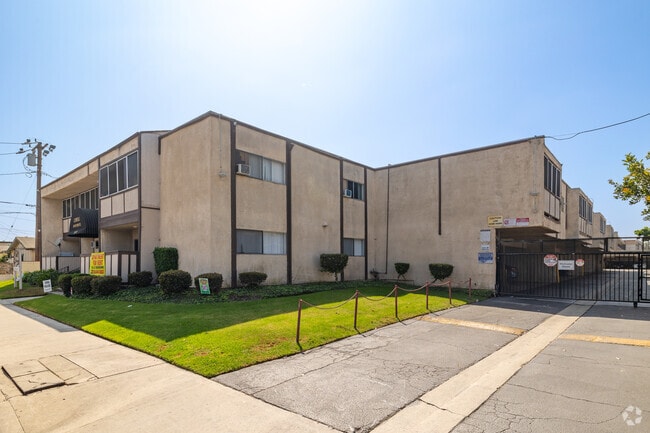
13613 Lemoli Ave, Hawthorne, CA 90250


Property Detail
13613 Lemoli Ave
4052-008-014
TRACT NO 874 DIVISION C (EX OF ST) LOT 76
Multifamilydwelling
Los Angeles
HAR3*
California
B and X Area of moderate flood hazard, usually the area between the limits of the 100-year and 500-year floods.
76
2025
0.90 AC
2025
Hawthorne
602506
Los Angeles
21,882 SF
Los Angeles-Long Beach-Glendale, CA
NEARBY LISTINGS FOR SALE OR LEASE
DEMOGRAPHICS near 13613 Lemoli Ave
1 mile
3 mile
5 mile
2025 Total Population
55,637
312,593
732,227
2030 Population
55,692
309,550
725,495
Pop Growth 2025-2030
+ 0.10%
(0.97%)
(0.92%)
Average Age
37
39
39
2025 Total Households
19,308
102,866
242,501
HH Growth 2025-2030
(0.01%)
(1.16%)
(1.06%)
Median Household Inc
$68,427
$79,102
$83,788
Avg Household Size
2.80
2.90
2.90
2025 Avg HH Vehicles
2.00
2.00
2.00
Median Home Value
$748,823
$777,522
$837,034
Median Year Built
1970
1960
1961
Nearby Places
Map Layers
Map Styles
 Street
 Aerial
Layers
 Traffic
 Biking
Places
Listings with unknown addresses are not visible on the map
- Restaurants
- Banks
- Shops
- Fitness
- Groceries
PUBLIC TRANSPORTATION
AIRPORT
Los Angeles International
Drive
Walk
Distance
Los Angeles International
13 min
7.8 mi
Long Beach (Daugherty Field)
Drive
Walk
Distance
Long Beach (Daugherty Field)
22 min
14.8 mi
Bob Hope
Drive
Walk
Distance
Bob Hope
41 min
30.3 mi
Freight Ports
Port of Long Beach
Drive
Walk
Distance
Port of Long Beach
25 min
16.6 mi
Nearby Properties
Address
Land Use
TOTAL SIZE
Lot Size
Zoning
Address
Land Use
TOTAL SIZE
Lot Size
Zoning
Address
Land Use
TOTAL SIZE
Lot Size
Zoning
Address
Land Use
TOTAL SIZE
Lot Size
Zoning
Address
Land Use
TOTAL SIZE
Lot Size
Zoning
Address
Land Use
TOTAL SIZE
Lot Size
Zoning
239,469 SF
9.56 AC
ESCM*
Address
Land Use
TOTAL SIZE
Lot Size
Zoning
944,791 SF
22.53 AC
ESCM*
Address
Land Use
TOTAL SIZE
Lot Size
Zoning
421,934 SF
8.24 AC
ESCM
Address
Land Use
TOTAL SIZE
Lot Size
Zoning
803,362 SF
41.24 AC
RBI-1A
Address
Land Use
TOTAL SIZE
Lot Size
Zoning
848,217 SF
36.09 AC
RBI-1A
Address
Land Use
TOTAL SIZE
Lot Size
Zoning
227,596 SF
14.38 AC
HAM1YY
Address
Land Use
TOTAL SIZE
Lot Size
Zoning
279,694 SF
3.19 AC
LCR1*
Address
Land Use
TOTAL SIZE
Lot Size
Zoning
1,504,661 SF
RBCR
Address
Land Use
TOTAL SIZE
Lot Size
Zoning
216,354 SF
3.52 AC
HAC3
Address
Land Use
TOTAL SIZE
Lot Size
Zoning
214,782 SF
3.66 AC
GAR3
Address
Land Use
TOTAL SIZE
Lot Size
Zoning
833,484 SF
6.62 AC
ESM2YY
Address
Land Use
TOTAL SIZE
Lot Size
Zoning
239,992 SF
4.72 AC
RBI-1B
Address
Land Use
TOTAL SIZE
Lot Size
Zoning
186,683 SF
1.74 AC
LCR1*
Address
Land Use
TOTAL SIZE
Lot Size
Zoning
986,604 SF
42.66 AC
HAM2YY
Address
Land Use
TOTAL SIZE
Lot Size
Zoning
59,422 SF
2.89 AC
HAM2YY
Address
Land Use
TOTAL SIZE
Lot Size
Zoning
203,587 SF
12.09 AC
ESCM*
Address
Land Use
TOTAL SIZE
Lot Size
Zoning
296,083 SF
13.62 AC
ESCM*
Address
Land Use
TOTAL SIZE
Lot Size
Zoning
207,972 SF
11.22 AC
HAM2
Address
Land Use
TOTAL SIZE
Lot Size
Zoning
316,111 SF
12.61 AC
RBI-1
Address
Land Use
TOTAL SIZE
Lot Size
Zoning
74,863 SF
3.06 AC
ESCM*
Address
Land Use
TOTAL SIZE
Lot Size
Zoning
169,758 SF
9.20 AC
LCR1*
Address
Land Use
TOTAL SIZE
Lot Size
Zoning
544,967 SF
10.74 AC
HAM2YY
Address
Land Use
TOTAL SIZE
Lot Size
Zoning
143,796 SF
5.57 AC
RBI-1A
Address
Land Use
TOTAL SIZE
Lot Size
Zoning
1,106,631 SF
1.12 AC
INC2YY
Address
Land Use
TOTAL SIZE
Lot Size
Zoning
111,254 SF
5.63 AC
INCR
The World's #1 Commercial Real Estate Marketplace
Connect with us
© 2026 CoStar Group
The information above has been obtained from sources believed reliable. While we do not doubt its accuracy we have not verified it and make no guarantee, warranty or representation about it. It is your responsibility to independently confirm its accuracy and completeness. Any projections, opinions, assumptions, or estimates used are for example only and do not represent the current or future performance of the property. The value of this transaction to you depends on tax and other factors which should be evaluated by your tax, financial, and legal advisors. You and your advisors should conduct a careful, independent investigation of the property to determine to your satisfaction the suitability of the property for your needs.