Property Record
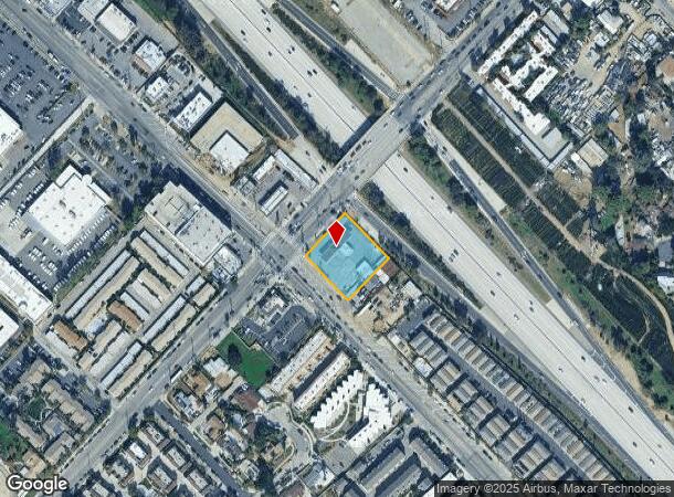
13618 Hubbard St, Sylmar, CA 91342
NEARBY LISTINGS FOR SALE OR LEASE
Property Detail
13618 Hubbard St
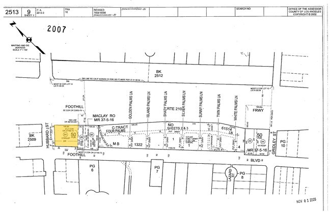
2513-009-054
Terraza Villa
Servicestation
THE MACLAY RANCHO LOT COM SE ON SW LINE OF BLK 50 200 FT AND N 43 0620 E 20 FT FROM MOST W COR OF SD BLK TH N 43 0620 E TO SW LINE OF FOOTHILL FRWY TH NW THEREON AND SW ON SE LINE OF HUBBARD ST OF FOOTHILL BLVD TO BEG PART OF BLK 50
X
Los Angeles
06037C1075G
California
2024
0.71 AC
2025
Eastern SFV
106403
Los Angeles
736 SF
Los Angeles-Long Beach-Glendale, CA
DEMOGRAPHICS near 13618 Hubbard St
1 Mile
3 Mile
5 Mile
2024 Total Population
33,592
144,830
274,407
2029 Population
32,579
139,043
263,332
Pop Growth 2024-2029
(3.02%)
(4.00%)
(4.04%)
Average Age
37
38
39
2024 Total Households
8,729
36,306
71,566
HH Growth 2024-2029
(3.15%)
(4.26%)
(4.28%)
Median Household Inc
$78,564
$75,775
$81,775
Avg Household Size
3.70
3.70
3.60
2024 Avg HH Vehicles
2.00
2.00
2.00
Median Home Value
$625,398
$639,683
$670,744
Median Year Built
1972
1968
1964
Nearby Places
Map Layers
Map Styles
 Street
 Aerial
- Restaurants
- Banks
- Shops
- Fitness
- Groceries
PUBLIC TRANSPORTATION
COMMUTER RAIL
Sylmar/San Fernando (Antelope Valley Line - Southern California Regional Rail Authority (Metrolink))
DRIVE
WALK
Distance
Sylmar/San Fernando (Antelope Valley Line - Southern California Regional Rail Authority (Metrolink))
4 min
1.7 mi
Sun Valley (Antelope Valley Line - Southern California Regional Rail Authority (Metrolink))
DRIVE
WALK
Distance
Sun Valley (Antelope Valley Line - Southern California Regional Rail Authority (Metrolink))
12 min
7.8 mi
AIRPORT
Bob Hope
DRIVE
WALK
Distance
Bob Hope
16 min
9.7 mi
Los Angeles International
DRIVE
WALK
Distance
Los Angeles International
40 min
29.5 mi
Freight Ports
Port of Long Beach
DRIVE
WALK
Distance
Port of Long Beach
62 min
48.8 mi
Nearby Properties
Address
Land Use
TOTAL SIZE
Lot Size
Zoning
Address
Land Use
TOTAL SIZE
Lot Size
Zoning
237,451 SF
13.93 AC
LAA2
Address
Land Use
TOTAL SIZE
Lot Size
Zoning
302,813 SF
13.10 AC
LAM1
Address
Land Use
TOTAL SIZE
Lot Size
Zoning
Address
Land Use
TOTAL SIZE
Lot Size
Zoning
196,404 SF
10.06 AC
LARD1.5
Address
Land Use
TOTAL SIZE
Lot Size
Zoning
185,568 SF
9.06 AC
LARD1.5
Address
Land Use
TOTAL SIZE
Lot Size
Zoning
182,309 SF
13.98 AC
LAM1
Address
Land Use
TOTAL SIZE
Lot Size
Zoning
169,259 SF
2.56 AC
LAC1
Address
Land Use
TOTAL SIZE
Lot Size
Zoning
176,704 SF
4.10 AC
LAR3
Address
Land Use
TOTAL SIZE
Lot Size
Zoning
176,160 SF
3.19 AC
LAR3
Address
Land Use
TOTAL SIZE
Lot Size
Zoning
Address
Land Use
TOTAL SIZE
Lot Size
Zoning
100,967 SF
11.78 AC
LAP
Address
Land Use
TOTAL SIZE
Lot Size
Zoning
150,041 SF
10.46 AC
LAA2
Address
Land Use
TOTAL SIZE
Lot Size
Zoning
105,541 SF
7.29 AC
LARA
Address
Land Use
TOTAL SIZE
Lot Size
Zoning
146,718 SF
7.36 AC
Address
Land Use
TOTAL SIZE
Lot Size
Zoning
146,718 SF
7.11 AC
SFM
Address
Land Use
TOTAL SIZE
Lot Size
Zoning
154,575 SF
12.20 AC
LAM3
Address
Land Use
TOTAL SIZE
Lot Size
Zoning
120,590 SF
9.52 AC
SFM2-C1P*
Address
Land Use
TOTAL SIZE
Lot Size
Zoning
179,394 SF
6.44 AC
LAC1
Address
Land Use
TOTAL SIZE
Lot Size
Zoning
108,012 SF
6.40 AC
LAR3
Address
Land Use
TOTAL SIZE
Lot Size
Zoning
140,411 SF
10.79 AC
LAM3
Address
Land Use
TOTAL SIZE
Lot Size
Zoning
44,480 SF
2.72 AC
LAM2
Address
Land Use
TOTAL SIZE
Lot Size
Zoning
110,096 SF
6.14 AC
LAM2
Address
Land Use
TOTAL SIZE
Lot Size
Zoning
99,966 SF
4.53 AC
LAM1
Address
Land Use
TOTAL SIZE
Lot Size
Zoning
138,229 SF
4.67 AC
SFM2*
Address
Land Use
TOTAL SIZE
Lot Size
Zoning
50,424 SF
3.32 AC
LAR3
Address
Land Use
TOTAL SIZE
Lot Size
Zoning
214,067 SF
8.50 AC
SFM2-C1P*
Address
Land Use
TOTAL SIZE
Lot Size
Zoning
86,301 SF
2.79 AC
LAR1
Address
Land Use
TOTAL SIZE
Lot Size
Zoning
58,260 SF
9.24 AC
LAC2
The World's #1 Commercial Real Estate Marketplace
Connect with us
© 2025 CoStar Group
The information above has been obtained from sources believed reliable. While we do not doubt its accuracy we have not verified it and make no guarantee, warranty or representation about it. It is your responsibility to independently confirm its accuracy and completeness. Any projections, opinions, assumptions, or estimates used are for example only and do not represent the current or future performance of the property. The value of this transaction to you depends on tax and other factors which should be evaluated by your tax, financial, and legal advisors. You and your advisors should conduct a careful, independent investigation of the property to determine to your satisfaction the suitability of the property for your needs.