Property Record
13620 Chicot Rd, Mabelvale, AR 72103
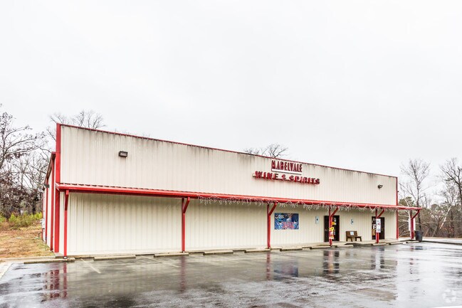

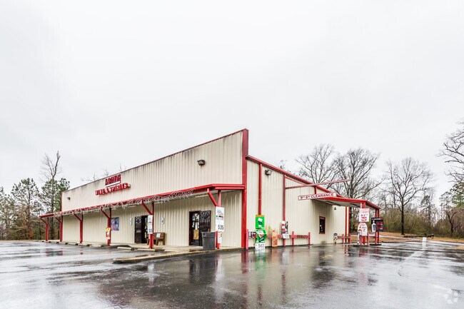
Property Detail
13620 Chicot Rd
45R-014-00-056-00
PT S1/2 SE BEG 30W OF SE COR SE SE N350 TO S R/W CO RD WLY ON R/W 617.94 S259.60 TO S SEC LN E600 TO BEG 14-1S-13W
Warehouse
Pulaski
B and X Area of moderate flood hazard, usually the area between the limits of the 100-year and 500-year floods.
Arkansas
2025
4.25 AC
2025
Outlying Pulaski County
004006
Little Rock/N Little Rock
6,000 SF
Little Rock-North Little Rock-Conway, AR
NEARBY LISTINGS FOR SALE OR LEASE
-
-
View all Mabelvale listings for sale on LoopNet.com
DEMOGRAPHICS near 13620 Chicot Rd
1 mile
3 mile
5 mile
2025 Total Population
1,719
22,751
66,820
2030 Population
1,805
23,216
68,179
Pop Growth 2025-2030
+ 5.00%
+ 2.04%
+ 2.03%
Average Age
39
37
37
2025 Total Households
629
8,488
25,554
HH Growth 2025-2030
+ 5.09%
+ 2.13%
+ 2.02%
Median Household Inc
$70,212
$53,335
$52,216
Avg Household Size
2.60
2.60
2.50
2025 Avg HH Vehicles
2.00
2.00
2.00
Median Home Value
$168,446
$148,076
$157,076
Median Year Built
1981
1978
1982
Nearby Places
Map Layers
Map Styles
 Street
 Aerial
Layers
 Traffic
 Biking
Places
Listings with unknown addresses are not visible on the map
- Restaurants
- Banks
- Shops
- Fitness
- Groceries
PUBLIC TRANSPORTATION
AIRPORT
Bill and Hillary Clinton Ntl/Adams Field
Drive
Walk
Distance
Bill and Hillary Clinton Ntl/Adams Field
19 min
13.5 mi
Freight Ports
Port of Shreveport
Drive
Walk
Distance
Port of Shreveport
246 min
227.9 mi
Nearby Properties
Address
Land Use
TOTAL SIZE
Lot Size
Zoning
Address
Land Use
TOTAL SIZE
Lot Size
Zoning
189,729 SF
57.75 AC
Address
Land Use
TOTAL SIZE
Lot Size
Zoning
10 SF
29.02 AC
Address
Land Use
TOTAL SIZE
Lot Size
Zoning
317,302 SF
44.38 AC
Address
Land Use
TOTAL SIZE
Lot Size
Zoning
201,499 SF
21.70 AC
Address
Land Use
TOTAL SIZE
Lot Size
Zoning
64,182 SF
17.80 AC
Address
Land Use
TOTAL SIZE
Lot Size
Zoning
309,271 SF
41.75 AC
Address
Land Use
TOTAL SIZE
Lot Size
Zoning
81,021 SF
10.28 AC
Address
Land Use
TOTAL SIZE
Lot Size
Zoning
16,032 SF
11.71 AC
Address
Land Use
TOTAL SIZE
Lot Size
Zoning
162,970 SF
12.66 AC
Address
Land Use
TOTAL SIZE
Lot Size
Zoning
103,722 SF
11.88 AC
Address
Land Use
TOTAL SIZE
Lot Size
Zoning
6,048 SF
10.23 AC
Address
Land Use
TOTAL SIZE
Lot Size
Zoning
22,756 SF
9.33 AC
Address
Land Use
TOTAL SIZE
Lot Size
Zoning
57,396 SF
10.92 AC
Address
Land Use
TOTAL SIZE
Lot Size
Zoning
60,728 SF
10.72 AC
Address
Land Use
TOTAL SIZE
Lot Size
Zoning
1,112 SF
36.04 AC
Address
Land Use
TOTAL SIZE
Lot Size
Zoning
100,000 SF
6.86 AC
Address
Land Use
TOTAL SIZE
Lot Size
Zoning
52.66 AC
Address
Land Use
TOTAL SIZE
Lot Size
Zoning
18,554 SF
4.12 AC
Address
Land Use
TOTAL SIZE
Lot Size
Zoning
600 SF
0.23 AC
Address
Land Use
TOTAL SIZE
Lot Size
Zoning
27,565 SF
5.70 AC
Address
Land Use
TOTAL SIZE
Lot Size
Zoning
70,350 SF
5.15 AC
Address
Land Use
TOTAL SIZE
Lot Size
Zoning
68,984 SF
2.37 AC
Address
Land Use
TOTAL SIZE
Lot Size
Zoning
68,984 SF
2.70 AC
Address
Land Use
TOTAL SIZE
Lot Size
Zoning
58,480 SF
2.43 AC
Address
Land Use
TOTAL SIZE
Lot Size
Zoning
31,110 SF
2.50 AC
Address
Land Use
TOTAL SIZE
Lot Size
Zoning
57,336 SF
2.40 AC
Address
Land Use
TOTAL SIZE
Lot Size
Zoning
20,478 SF
1.85 AC
Address
Land Use
TOTAL SIZE
Lot Size
Zoning
6,253 SF
2.30 AC
Address
Land Use
TOTAL SIZE
Lot Size
Zoning
24,180 SF
3.64 AC
Address
Land Use
TOTAL SIZE
Lot Size
Zoning
9,180 SF
12.77 AC
The World's #1 Commercial Real Estate Marketplace
Connect with us
© 2026 CoStar Group
The information above has been obtained from sources believed reliable. While we do not doubt its accuracy we have not verified it and make no guarantee, warranty or representation about it. It is your responsibility to independently confirm its accuracy and completeness. Any projections, opinions, assumptions, or estimates used are for example only and do not represent the current or future performance of the property. The value of this transaction to you depends on tax and other factors which should be evaluated by your tax, financial, and legal advisors. You and your advisors should conduct a careful, independent investigation of the property to determine to your satisfaction the suitability of the property for your needs.