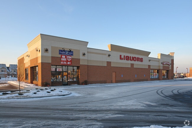
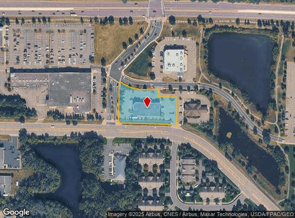
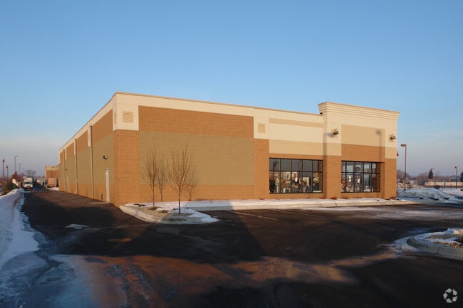
Property Record
13627 Quinn St Nw, Andover, MN 55304
NEARBY LISTINGS FOR SALE OR LEASE
Property Detail
13627 Quinn St Nw
Minneapolis-St. Paul-Bloomington, MN-WI
Andover Marketplace East 2Nd
34-32-24-31-0155
LOT 1 BLOCK 1 ANDOVER MARKETPLACE EAST 2ND
Commercialnec
Anoka
X
Minnesota
27053C0100F
1
2025
1.43 AC
2025
Coon Rapids
050208
Minneapolis/St Paul
11,002 SF
DEMOGRAPHICS near 13627 Quinn St Nw
1 Mile
3 Mile
5 Mile
2024 Total Population
7,755
56,969
157,454
2029 Population
7,990
58,907
162,394
Pop Growth 2024-2029
+ 3.03%
+ 3.40%
+ 3.14%
Average Age
40
40
40
2024 Total Households
2,686
20,426
58,401
HH Growth 2024-2029
+ 3.09%
+ 3.42%
+ 3.18%
Median Household Inc
$103,692
$99,770
$89,449
Avg Household Size
2.80
2.70
2.60
2024 Avg HH Vehicles
2.00
2.00
2.00
Median Home Value
$302,587
$304,416
$286,053
Median Year Built
1988
1988
1985
Nearby Places
Map Layers
Map Styles
 Street
 Aerial
- Restaurants
- Banks
- Shops
- Fitness
- Groceries
PUBLIC TRANSPORTATION
COMMUTER RAIL
Coon Rapids-Riverdale Station (Northstar Corridor - Northstar Commuter Rail)
DRIVE
WALK
Distance
Coon Rapids-Riverdale Station (Northstar Corridor - Northstar Commuter Rail)
7 min
3.2 mi
Anoka Station (Northstar Corridor - Northstar Commuter Rail)
DRIVE
WALK
Distance
Anoka Station (Northstar Corridor - Northstar Commuter Rail)
10 min
4.9 mi
AIRPORT
Minneapolis-St Paul International/Wold-Chamberlain
DRIVE
WALK
Distance
Minneapolis-St Paul International/Wold-Chamberlain
49 min
34.2 mi
Nearby Properties
Address
Land Use
TOTAL SIZE
Lot Size
Zoning
Address
Land Use
TOTAL SIZE
Lot Size
Zoning
412,914 SF
40 AC
Address
Land Use
TOTAL SIZE
Lot Size
Zoning
2,400 SF
72.45 AC
Address
Land Use
TOTAL SIZE
Lot Size
Zoning
5,110 SF
38.62 AC
Address
Land Use
TOTAL SIZE
Lot Size
Zoning
Address
Land Use
TOTAL SIZE
Lot Size
Zoning
122,816 SF
27.84 AC
Address
Land Use
TOTAL SIZE
Lot Size
Zoning
Address
Land Use
TOTAL SIZE
Lot Size
Zoning
225,748 SF
Address
Land Use
TOTAL SIZE
Lot Size
Zoning
447,671 SF
78.33 AC
Address
Land Use
TOTAL SIZE
Lot Size
Zoning
133,906 SF
34.37 AC
Address
Land Use
TOTAL SIZE
Lot Size
Zoning
159,335 SF
13.64 AC
Address
Land Use
TOTAL SIZE
Lot Size
Zoning
7,888 SF
40 AC
Address
Land Use
TOTAL SIZE
Lot Size
Zoning
168,887 SF
7.01 AC
Address
Land Use
TOTAL SIZE
Lot Size
Zoning
148 SF
39.49 AC
Address
Land Use
TOTAL SIZE
Lot Size
Zoning
164,472 SF
10.95 AC
Address
Land Use
TOTAL SIZE
Lot Size
Zoning
151,862 SF
12.97 AC
Address
Land Use
TOTAL SIZE
Lot Size
Zoning
811,860 SF
Address
Land Use
TOTAL SIZE
Lot Size
Zoning
160,668 SF
14.87 AC
Address
Land Use
TOTAL SIZE
Lot Size
Zoning
89,466 SF
5.76 AC
Address
Land Use
TOTAL SIZE
Lot Size
Zoning
195,228 SF
14.77 AC
Address
Land Use
TOTAL SIZE
Lot Size
Zoning
172,335 SF
13.41 AC
Address
Land Use
TOTAL SIZE
Lot Size
Zoning
Address
Land Use
TOTAL SIZE
Lot Size
Zoning
84,924 SF
12.49 AC
Address
Land Use
TOTAL SIZE
Lot Size
Zoning
99,846 SF
30.31 AC
Address
Land Use
TOTAL SIZE
Lot Size
Zoning
124,951 SF
12.67 AC
Address
Land Use
TOTAL SIZE
Lot Size
Zoning
152,040 SF
20.71 AC
Address
Land Use
TOTAL SIZE
Lot Size
Zoning
Address
Land Use
TOTAL SIZE
Lot Size
Zoning
150,478 SF
12.21 AC
Address
Land Use
TOTAL SIZE
Lot Size
Zoning
Address
Land Use
TOTAL SIZE
Lot Size
Zoning
384 SF
15.85 AC
M-2
Address
Land Use
TOTAL SIZE
Lot Size
Zoning
63,040 SF
9.90 AC
The World's #1 Commercial Real Estate Marketplace
Connect with us
© 2025 CoStar Group
The information above has been obtained from sources believed reliable. While we do not doubt its accuracy we have not verified it and make no guarantee, warranty or representation about it. It is your responsibility to independently confirm its accuracy and completeness. Any projections, opinions, assumptions, or estimates used are for example only and do not represent the current or future performance of the property. The value of this transaction to you depends on tax and other factors which should be evaluated by your tax, financial, and legal advisors. You and your advisors should conduct a careful, independent investigation of the property to determine to your satisfaction the suitability of the property for your needs.