Property Record
1364 Hamel Rd, Hamel, MN 55340
NEARBY LISTINGS FOR SALE OR LEASE
Property Detail
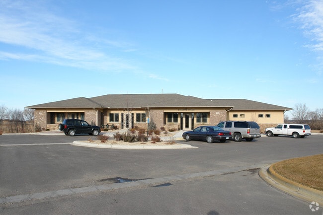
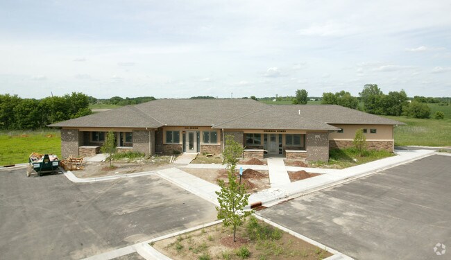
1364 Hamel Rd
Minneapolis-St. Paul-Bloomington, MN-WI
Medina Business Suites
11-118-23-31-0006
LOT 004 BLOCK 001 A MEDINA BUSINESS SUITES SW 30X69.5
Commercialnec
Hennepin
X
Minnesota
27053C0166F
4
2024
0.06 AC
2024
I-394 Corridor
027101
Minneapolis/St Paul
DEMOGRAPHICS near 1364 Hamel Rd
1 mile
3 mile
5 mile
2024 Total Population
937
18,572
77,543
2029 Population
914
18,504
76,566
Pop Growth 2024-2029
(2.45%)
(0.37%)
(1.26%)
Average Age
36
38
39
2024 Total Households
287
6,051
27,515
HH Growth 2024-2029
(2.44%)
(0.66%)
(1.48%)
Median Household Inc
$234,104
$182,592
$153,326
Avg Household Size
3.20
3.00
2.80
2024 Avg HH Vehicles
2.00
2.00
2.00
Median Home Value
$731,343
$632,873
$500,735
Median Year Built
2004
2002
1994
Nearby Places
Map Layers
Map Styles
 Street
 Aerial
Transit
 Traffic
 Biking
Places
Listings with unknown addresses are not visible on the map
- Restaurants
- Banks
- Shops
- Fitness
- Groceries
PUBLIC TRANSPORTATION
AIRPORT
Minneapolis-St Paul International/Wold-Chamberlain
Drive
Walk
Distance
Minneapolis-St Paul International/Wold-Chamberlain
41 min
28.1 mi
Freight Ports
Port Milwaukee
Drive
Walk
Distance
Port Milwaukee
401 min
355.8 mi
Nearby Properties
Address
Land Use
TOTAL SIZE
Lot Size
Zoning
Address
Land Use
TOTAL SIZE
Lot Size
Zoning
21.09 AC
Address
Land Use
TOTAL SIZE
Lot Size
Zoning
Address
Land Use
TOTAL SIZE
Lot Size
Zoning
Address
Land Use
TOTAL SIZE
Lot Size
Zoning
25.53 AC
Address
Land Use
TOTAL SIZE
Lot Size
Zoning
Address
Land Use
TOTAL SIZE
Lot Size
Zoning
32.70 AC
Address
Land Use
TOTAL SIZE
Lot Size
Zoning
Address
Land Use
TOTAL SIZE
Lot Size
Zoning
25.11 AC
Address
Land Use
TOTAL SIZE
Lot Size
Zoning
17.16 AC
Address
Land Use
TOTAL SIZE
Lot Size
Zoning
33.02 AC
Address
Land Use
TOTAL SIZE
Lot Size
Zoning
42.54 AC
Address
Land Use
TOTAL SIZE
Lot Size
Zoning
10.70 AC
Address
Land Use
TOTAL SIZE
Lot Size
Zoning
27,265 SF
69.23 AC
Address
Land Use
TOTAL SIZE
Lot Size
Zoning
26.54 AC
Address
Land Use
TOTAL SIZE
Lot Size
Zoning
11.52 AC
Address
Land Use
TOTAL SIZE
Lot Size
Zoning
10.79 AC
Address
Land Use
TOTAL SIZE
Lot Size
Zoning
9.82 AC
Address
Land Use
TOTAL SIZE
Lot Size
Zoning
10,652 SF
16.55 AC
Address
Land Use
TOTAL SIZE
Lot Size
Zoning
3.10 AC
Address
Land Use
TOTAL SIZE
Lot Size
Zoning
1,100 SF
4.63 AC
Address
Land Use
TOTAL SIZE
Lot Size
Zoning
13,818 SF
27.88 AC
Address
Land Use
TOTAL SIZE
Lot Size
Zoning
Address
Land Use
TOTAL SIZE
Lot Size
Zoning
8,606 SF
11.98 AC
Address
Land Use
TOTAL SIZE
Lot Size
Zoning
9,660 SF
27.17 AC
Address
Land Use
TOTAL SIZE
Lot Size
Zoning
13,915 SF
15.61 AC
Address
Land Use
TOTAL SIZE
Lot Size
Zoning
3.85 AC
Address
Land Use
TOTAL SIZE
Lot Size
Zoning
Address
Land Use
TOTAL SIZE
Lot Size
Zoning
10,796 SF
6.94 AC
Address
Land Use
TOTAL SIZE
Lot Size
Zoning
10,164 SF
16.08 AC
Address
Land Use
TOTAL SIZE
Lot Size
Zoning
1,720 SF
18.07 AC
The World's #1 Commercial Real Estate Marketplace
Connect with us
© 2026 CoStar Group
The information above has been obtained from sources believed reliable. While we do not doubt its accuracy we have not verified it and make no guarantee, warranty or representation about it. It is your responsibility to independently confirm its accuracy and completeness. Any projections, opinions, assumptions, or estimates used are for example only and do not represent the current or future performance of the property. The value of this transaction to you depends on tax and other factors which should be evaluated by your tax, financial, and legal advisors. You and your advisors should conduct a careful, independent investigation of the property to determine to your satisfaction the suitability of the property for your needs.