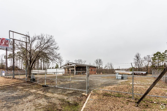
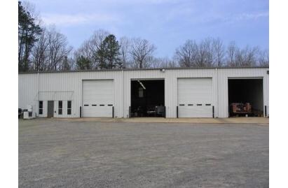
Property Record
13640 Interstate 30 N, Benton, AR 72019

Property Detail
13640 Interstate 30 N
001-09108-000
PT SW SE 2023-004662 & 2023-022365 & 2023-022366 & 2023-022815
Officebuilding
Saline
B and X Area of moderate flood hazard, usually the area between the limits of the 100-year and 500-year floods.
Arkansas
2025
2.59 AC
2025
Saline County
010303
Little Rock/N Little Rock
11,050 SF
Little Rock-North Little Rock-Conway, AR
NEARBY LISTINGS FOR SALE OR LEASE
-
-
View all Benton listings for sale on LoopNet.com
DEMOGRAPHICS near 13640 Interstate 30 N
1 mile
3 mile
5 mile
2025 Total Population
416
10,925
32,084
2030 Population
442
11,572
33,890
Pop Growth 2025-2030
+ 6.25%
+ 5.92%
+ 5.63%
Average Age
40
40
39
2025 Total Households
150
4,299
12,322
HH Growth 2025-2030
+ 6.67%
+ 6.12%
+ 5.75%
Median Household Inc
$107,065
$73,624
$74,283
Avg Household Size
2.70
2.40
2.50
2025 Avg HH Vehicles
2.00
2.00
2.00
Median Home Value
$254,166
$183,066
$188,167
Median Year Built
2000
1982
1987
Nearby Places
Map Layers
Map Styles
 Street
 Aerial
Layers
 Traffic
 Biking
Places
Listings with unknown addresses are not visible on the map
- Restaurants
- Banks
- Shops
- Fitness
- Groceries
PUBLIC TRANSPORTATION
AIRPORT
Bill and Hillary Clinton Ntl/Adams Field
Drive
Walk
Distance
Bill and Hillary Clinton Ntl/Adams Field
41 min
34.6 mi
Freight Ports
Port of Shreveport
Drive
Walk
Distance
Port of Shreveport
219 min
206.8 mi
Nearby Properties
Address
Land Use
TOTAL SIZE
Lot Size
Zoning
Address
Land Use
TOTAL SIZE
Lot Size
Zoning
239,389 SF
40 AC
Address
Land Use
TOTAL SIZE
Lot Size
Zoning
102,000 SF
4.93 AC
Address
Land Use
TOTAL SIZE
Lot Size
Zoning
45,560 SF
2.63 AC
Address
Land Use
TOTAL SIZE
Lot Size
Zoning
6,480 SF
0.69 AC
Address
Land Use
TOTAL SIZE
Lot Size
Zoning
19,336 SF
1.53 AC
Address
Land Use
TOTAL SIZE
Lot Size
Zoning
11,975 SF
3.22 AC
Address
Land Use
TOTAL SIZE
Lot Size
Zoning
22,926 SF
5.75 AC
Address
Land Use
TOTAL SIZE
Lot Size
Zoning
5,436 SF
2.29 AC
Address
Land Use
TOTAL SIZE
Lot Size
Zoning
17,648 SF
0.39 AC
Address
Land Use
TOTAL SIZE
Lot Size
Zoning
4,115 SF
1.63 AC
Address
Land Use
TOTAL SIZE
Lot Size
Zoning
10,000 SF
0.18 AC
Address
Land Use
TOTAL SIZE
Lot Size
Zoning
40,660 SF
3.84 AC
Address
Land Use
TOTAL SIZE
Lot Size
Zoning
27.41 AC
Address
Land Use
TOTAL SIZE
Lot Size
Zoning
17,543 SF
83.76 AC
Address
Land Use
TOTAL SIZE
Lot Size
Zoning
19,724 SF
2 AC
Address
Land Use
TOTAL SIZE
Lot Size
Zoning
9,945 SF
1.21 AC
Address
Land Use
TOTAL SIZE
Lot Size
Zoning
5,000 SF
8.05 AC
Address
Land Use
TOTAL SIZE
Lot Size
Zoning
4,500 SF
9.08 AC
Address
Land Use
TOTAL SIZE
Lot Size
Zoning
33,100 SF
6.26 AC
Address
Land Use
TOTAL SIZE
Lot Size
Zoning
11,856 SF
2.34 AC
Address
Land Use
TOTAL SIZE
Lot Size
Zoning
9,654 SF
3.86 AC
Address
Land Use
TOTAL SIZE
Lot Size
Zoning
6.87 AC
Address
Land Use
TOTAL SIZE
Lot Size
Zoning
10,500 SF
1.86 AC
Address
Land Use
TOTAL SIZE
Lot Size
Zoning
6,000 SF
0.23 AC
Address
Land Use
TOTAL SIZE
Lot Size
Zoning
9,818 SF
0.28 AC
Address
Land Use
TOTAL SIZE
Lot Size
Zoning
19,188 SF
1.37 AC
Address
Land Use
TOTAL SIZE
Lot Size
Zoning
10,981 SF
1.37 AC
Address
Land Use
TOTAL SIZE
Lot Size
Zoning
4,097 SF
0.75 AC
Address
Land Use
TOTAL SIZE
Lot Size
Zoning
11,879 SF
0.34 AC
Address
Land Use
TOTAL SIZE
Lot Size
Zoning
885 SF
1.44 AC
The World's #1 Commercial Real Estate Marketplace
Connect with us
© 2026 CoStar Group
The information above has been obtained from sources believed reliable. While we do not doubt its accuracy we have not verified it and make no guarantee, warranty or representation about it. It is your responsibility to independently confirm its accuracy and completeness. Any projections, opinions, assumptions, or estimates used are for example only and do not represent the current or future performance of the property. The value of this transaction to you depends on tax and other factors which should be evaluated by your tax, financial, and legal advisors. You and your advisors should conduct a careful, independent investigation of the property to determine to your satisfaction the suitability of the property for your needs.