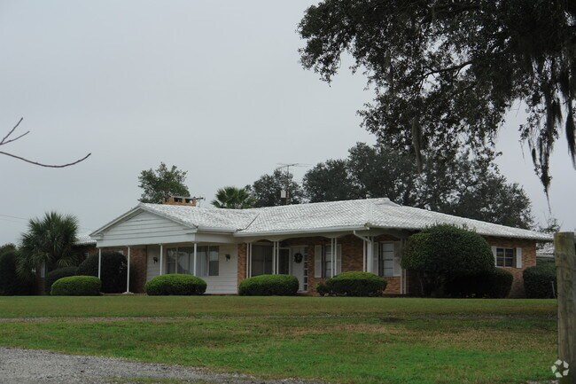
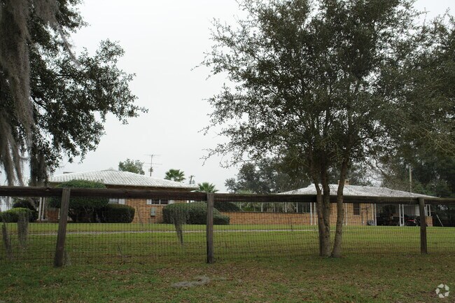
Property Record
13640 Nw Us Highway 441, Alachua, FL 32615

Property Detail
13640 Nw Us Highway 441
05964-009-000
FERNANDEZ GRANT L L DELL ESTATE S-D PB A-47 COM NW COR OF SEC 19-8-19 S 2 DEG 47 MIN E 922.74 FT TO S R/W US 441 S 64 DEG E ALONG R/W 1639.55 FT S 6 DEG 39 MIN W 724.40 FT TO POB S 83 DEG 21 MIN E 659.47 FT S 6 DEG 39 MIN W 330.27 FT N 83 DEG 21 MIN
Officebuilding
Alachua
ILW
Florida
B and X Area of moderate flood hazard, usually the area between the limits of the 100-year and 500-year floods.
l
2025
5 AC
2025
Gainesville
001817
Other Market Areas
3,621 SF
Gainesville, FL
NEARBY LISTINGS FOR SALE OR LEASE
DEMOGRAPHICS near 13640 Nw Us Highway 441
1 mile
3 mile
5 mile
2025 Total Population
676
6,724
15,509
2030 Population
712
7,058
16,242
Pop Growth 2025-2030
+ 5.33%
+ 4.97%
+ 4.73%
Average Age
42
42
42
2025 Total Households
280
2,691
6,272
HH Growth 2025-2030
+ 5.71%
+ 5.54%
+ 5.31%
Median Household Inc
$97,249
$75,779
$87,238
Avg Household Size
2.40
2.50
2.50
2025 Avg HH Vehicles
2.00
2.00
2.00
Median Home Value
$297,886
$301,777
$325,059
Median Year Built
1995
1992
1995
Nearby Places
Map Layers
Map Styles
 Street
 Aerial
Transit
 Traffic
 Biking
Places
Listings with unknown addresses are not visible on the map
- Restaurants
- Banks
- Shops
- Fitness
- Groceries
PUBLIC TRANSPORTATION
AIRPORT
Gainesville Regional
Drive
Walk
Distance
Gainesville Regional
26 min
14.4 mi
Freight Ports
Jacksonville Port
Drive
Walk
Distance
Jacksonville Port
112 min
84.2 mi
Nearby Properties
Address
Land Use
TOTAL SIZE
Lot Size
Zoning
Address
Land Use
TOTAL SIZE
Lot Size
Zoning
204,258 SF
23.24 AC
ILW
Address
Land Use
TOTAL SIZE
Lot Size
Zoning
147,781 SF
17.01 AC
PUD
Address
Land Use
TOTAL SIZE
Lot Size
Zoning
99,873 SF
34 AC
A
Address
Land Use
TOTAL SIZE
Lot Size
Zoning
200,050 SF
18.60 AC
RSF-3
Address
Land Use
TOTAL SIZE
Lot Size
Zoning
76,504 SF
20 AC
RSF-3
Address
Land Use
TOTAL SIZE
Lot Size
Zoning
28,727 SF
6.04 AC
PUD
Address
Land Use
TOTAL SIZE
Lot Size
Zoning
43,646 SF
4.90 AC
ILW
Address
Land Use
TOTAL SIZE
Lot Size
Zoning
40,804 SF
3.94 AC
ILW
Address
Land Use
TOTAL SIZE
Lot Size
Zoning
83,635 SF
182.70 AC
PUD
Address
Land Use
TOTAL SIZE
Lot Size
Zoning
95,185 SF
7.72 AC
CI
Address
Land Use
TOTAL SIZE
Lot Size
Zoning
41,464 SF
3.96 AC
PUD
Address
Land Use
TOTAL SIZE
Lot Size
Zoning
54,768 SF
11.63 AC
ILW
Address
Land Use
TOTAL SIZE
Lot Size
Zoning
15,922 SF
390 AC
A
Address
Land Use
TOTAL SIZE
Lot Size
Zoning
23,683 SF
6.02 AC
ILW
Address
Land Use
TOTAL SIZE
Lot Size
Zoning
44,384 SF
7.50 AC
CP
Address
Land Use
TOTAL SIZE
Lot Size
Zoning
21,446 SF
4.05 AC
ILW
Address
Land Use
TOTAL SIZE
Lot Size
Zoning
37,274 SF
6.14 AC
PUD
Address
Land Use
TOTAL SIZE
Lot Size
Zoning
1,189.30 AC
A
Address
Land Use
TOTAL SIZE
Lot Size
Zoning
31,248 SF
3.27 AC
PUD
Address
Land Use
TOTAL SIZE
Lot Size
Zoning
132,880 SF
20 AC
IG
Address
Land Use
TOTAL SIZE
Lot Size
Zoning
24,154 SF
3.46 AC
PUD
Address
Land Use
TOTAL SIZE
Lot Size
Zoning
64,052 SF
35.96 AC
ILW
Address
Land Use
TOTAL SIZE
Lot Size
Zoning
35,745 SF
9.73 AC
GF
Address
Land Use
TOTAL SIZE
Lot Size
Zoning
57,014 SF
5.82 AC
PUD
Address
Land Use
TOTAL SIZE
Lot Size
Zoning
31,928 SF
2.86 AC
PUD
Address
Land Use
TOTAL SIZE
Lot Size
Zoning
47,612 SF
7.33 AC
CI
Address
Land Use
TOTAL SIZE
Lot Size
Zoning
25,876 SF
4.13 AC
RSF-3
Address
Land Use
TOTAL SIZE
Lot Size
Zoning
55,136 SF
11.08 AC
RSF-3
Address
Land Use
TOTAL SIZE
Lot Size
Zoning
31,880 SF
3.32 AC
PUD
Address
Land Use
TOTAL SIZE
Lot Size
Zoning
47,220 SF
6.64 AC
RSF-3
The World's #1 Commercial Real Estate Marketplace
Connect with us
© 2026 CoStar Group
The information above has been obtained from sources believed reliable. While we do not doubt its accuracy we have not verified it and make no guarantee, warranty or representation about it. It is your responsibility to independently confirm its accuracy and completeness. Any projections, opinions, assumptions, or estimates used are for example only and do not represent the current or future performance of the property. The value of this transaction to you depends on tax and other factors which should be evaluated by your tax, financial, and legal advisors. You and your advisors should conduct a careful, independent investigation of the property to determine to your satisfaction the suitability of the property for your needs.