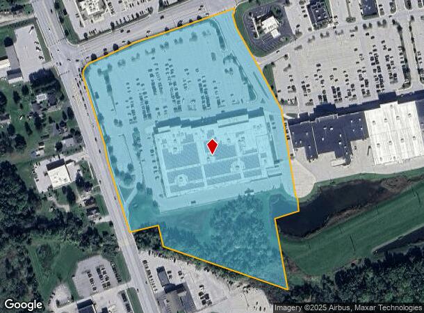
Property Record
1365 Carlisle Pike, Hanover, PA 17331

NEARBY LISTINGS FOR SALE OR LEASE
-
-
-
-
-
No Photo
-
-
-
View all Hanover listings for sale on LoopNet.com
Property Detail
1365 Carlisle Pike
44-000-ED-0014.A0-00000
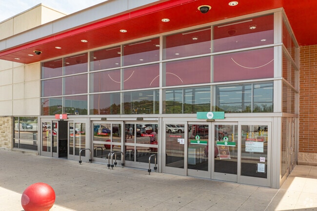
Gateway Hanover
Departmentstore
York
AE
Pennsylvania
42133C0403F
15.30 AC
2025
York County
2025
Philadelphia
022000
York-Hanover, PA
135,174 SF
DEMOGRAPHICS near 1365 Carlisle Pike
1 Mile
3 Mile
5 Mile
2024 Total Population
1,567
36,960
66,638
2029 Population
1,591
37,709
68,114
Pop Growth 2024-2029
+ 1.53%
+ 2.03%
+ 2.21%
Average Age
50
42
43
2024 Total Households
789
15,547
26,811
HH Growth 2024-2029
+ 1.39%
+ 2.08%
+ 2.25%
Median Household Inc
$62,354
$63,058
$67,667
Avg Household Size
2.00
2.30
2.40
2024 Avg HH Vehicles
2.00
2.00
2.00
Median Home Value
$218,421
$180,659
$199,454
Median Year Built
1977
1966
1978
Nearby Places
Map Layers
Map Styles
 Street
 Aerial
- Restaurants
- Banks
- Shops
- Fitness
- Groceries
SALE & LEASE HISTORY
LISTING DATE
SALE/LEASE

Sep 25, 2018
For Lease
Nov 19, 2019
For Sale
May 11, 2022
For Sale
Nearby Properties
Address
Land Use
TOTAL SIZE
Lot Size
Zoning
Address
Land Use
TOTAL SIZE
Lot Size
Zoning
65,738 SF
89.96 AC
RS
Address
Land Use
TOTAL SIZE
Lot Size
Zoning
35.99 AC
Address
Land Use
TOTAL SIZE
Lot Size
Zoning
2,331 SF
104.05 AC
CI
Address
Land Use
TOTAL SIZE
Lot Size
Zoning
93.98 AC
CI
Address
Land Use
TOTAL SIZE
Lot Size
Zoning
1,297.86 AC
I
Address
Land Use
TOTAL SIZE
Lot Size
Zoning
23,050 SF
26.70 AC
CM
Address
Land Use
TOTAL SIZE
Lot Size
Zoning
116.36 AC
A
Address
Land Use
TOTAL SIZE
Lot Size
Zoning
109.96 AC
HR
Address
Land Use
TOTAL SIZE
Lot Size
Zoning
33,593 SF
Address
Land Use
TOTAL SIZE
Lot Size
Zoning
109.27 AC
CI
Address
Land Use
TOTAL SIZE
Lot Size
Zoning
12.32 AC
CI
Address
Land Use
TOTAL SIZE
Lot Size
Zoning
129,869 SF
44.23 AC
ID
Address
Land Use
TOTAL SIZE
Lot Size
Zoning
190,175 SF
20.98 AC
ID
Address
Land Use
TOTAL SIZE
Lot Size
Zoning
24.39 AC
CI
Address
Land Use
TOTAL SIZE
Lot Size
Zoning
195,797 SF
20.31 AC
CM
Address
Land Use
TOTAL SIZE
Lot Size
Zoning
360,608 SF
46.91 AC
ID
Address
Land Use
TOTAL SIZE
Lot Size
Zoning
137,390 SF
17.47 AC
M
Address
Land Use
TOTAL SIZE
Lot Size
Zoning
16,669 SF
1.51 AC
Address
Land Use
TOTAL SIZE
Lot Size
Zoning
386,528 SF
2.35 AC
ID
Address
Land Use
TOTAL SIZE
Lot Size
Zoning
143,998 SF
21.94 AC
I
Address
Land Use
TOTAL SIZE
Lot Size
Zoning
207,780 SF
16.72 AC
CM
Address
Land Use
TOTAL SIZE
Lot Size
Zoning
13.23 AC
CI
Address
Land Use
TOTAL SIZE
Lot Size
Zoning
149,760 SF
22.93 AC
I
Address
Land Use
TOTAL SIZE
Lot Size
Zoning
13.32 AC
CI
Address
Land Use
TOTAL SIZE
Lot Size
Zoning
60,590 SF
11.04 AC
IND
Address
Land Use
TOTAL SIZE
Lot Size
Zoning
67,650 SF
7.42 AC
RS
Address
Land Use
TOTAL SIZE
Lot Size
Zoning
376,800 SF
26.23 AC
ID
Address
Land Use
TOTAL SIZE
Lot Size
Zoning
271,646 SF
22.51 AC
IND
Address
Land Use
TOTAL SIZE
Lot Size
Zoning
Address
Land Use
TOTAL SIZE
Lot Size
Zoning
291,626 SF
39.16 AC
ID
The World's #1 Commercial Real Estate Marketplace
Connect with us
© 2026 CoStar Group
The information above has been obtained from sources believed reliable. While we do not doubt its accuracy we have not verified it and make no guarantee, warranty or representation about it. It is your responsibility to independently confirm its accuracy and completeness. Any projections, opinions, assumptions, or estimates used are for example only and do not represent the current or future performance of the property. The value of this transaction to you depends on tax and other factors which should be evaluated by your tax, financial, and legal advisors. You and your advisors should conduct a careful, independent investigation of the property to determine to your satisfaction the suitability of the property for your needs.