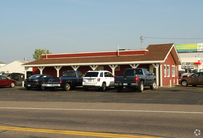
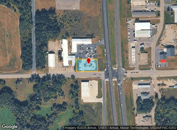
Property Record
1365 Constance Blvd Ne, Andover, MN 55304

NEARBY LISTINGS FOR SALE OR LEASE
-
-
View all Andover listings for sale on LoopNet.com
Property Detail
1365 Constance Blvd Ne
17-32-23-21-0006
UNPLATTED HAM LAKE TWP TH PT OF NE 1/4 OF NW 1/4 OF SEC 17 32 23 DESC AS FOL, COM AT INTERSECTION OF WLY RT OF WAY LINE OF ST TRK HWY NO 65 & S LINE OF SD NE1/4 OF NW 1/4, TH W ALONG S LINE OF SD N E 1/4 OF NW 1/4A DIST OF 210 FT, TH N & PRLL WITH E
Commercialnec
Anoka
X
Minnesota
27003C0215E
0.56 AC
2025
Coon Rapids
2025
Minneapolis/St Paul
050235
Minneapolis-St. Paul-Bloomington, MN-WI
684 SF
DEMOGRAPHICS near 1365 Constance Blvd Ne
1 Mile
3 Mile
5 Mile
2024 Total Population
1,903
14,881
53,678
2029 Population
1,976
15,513
55,895
Pop Growth 2024-2029
+ 3.84%
+ 4.25%
+ 4.13%
Average Age
40
40
39
2024 Total Households
697
5,108
18,076
HH Growth 2024-2029
+ 3.73%
+ 4.27%
+ 4.09%
Median Household Inc
$79,348
$110,601
$119,391
Avg Household Size
2.70
2.90
2.90
2024 Avg HH Vehicles
2.00
3.00
2.00
Median Home Value
$328,195
$384,351
$372,247
Median Year Built
1982
1991
1994
Nearby Places
Map Layers
Map Styles
 Street
 Aerial
- Restaurants
- Banks
- Shops
- Fitness
- Groceries
PUBLIC TRANSPORTATION
AIRPORT
Minneapolis-St Paul International/Wold-Chamberlain
DRIVE
WALK
Distance
Minneapolis-St Paul International/Wold-Chamberlain
47 min
32.7 mi
Freight Ports
Port Milwaukee
DRIVE
WALK
Distance
Port Milwaukee
392 min
354.9 mi
Nearby Properties
Address
Land Use
TOTAL SIZE
Lot Size
Zoning
Address
Land Use
TOTAL SIZE
Lot Size
Zoning
5.98 AC
Address
Land Use
TOTAL SIZE
Lot Size
Zoning
70,304 SF
Address
Land Use
TOTAL SIZE
Lot Size
Zoning
53,180 SF
30.46 AC
Address
Land Use
TOTAL SIZE
Lot Size
Zoning
58,977 SF
5.65 AC
Address
Land Use
TOTAL SIZE
Lot Size
Zoning
55,932 SF
5.39 AC
Address
Land Use
TOTAL SIZE
Lot Size
Zoning
28,600 SF
4.37 AC
Address
Land Use
TOTAL SIZE
Lot Size
Zoning
1,182 SF
20.50 AC
Address
Land Use
TOTAL SIZE
Lot Size
Zoning
22,185 SF
Address
Land Use
TOTAL SIZE
Lot Size
Zoning
32,000 SF
5.25 AC
Address
Land Use
TOTAL SIZE
Lot Size
Zoning
62,624 SF
12 AC
Address
Land Use
TOTAL SIZE
Lot Size
Zoning
1,120 SF
6.02 AC
Address
Land Use
TOTAL SIZE
Lot Size
Zoning
Address
Land Use
TOTAL SIZE
Lot Size
Zoning
33,992 SF
2.24 AC
Address
Land Use
TOTAL SIZE
Lot Size
Zoning
37,048 SF
2.58 AC
Address
Land Use
TOTAL SIZE
Lot Size
Zoning
36,159 SF
3.96 AC
Address
Land Use
TOTAL SIZE
Lot Size
Zoning
26,900 SF
7.08 AC
Address
Land Use
TOTAL SIZE
Lot Size
Zoning
5,290 SF
2.80 AC
Address
Land Use
TOTAL SIZE
Lot Size
Zoning
19,557 SF
21.93 AC
Address
Land Use
TOTAL SIZE
Lot Size
Zoning
9,766 SF
67.67 AC
Address
Land Use
TOTAL SIZE
Lot Size
Zoning
3,000 SF
12.75 AC
Address
Land Use
TOTAL SIZE
Lot Size
Zoning
23,920 SF
2.83 AC
Address
Land Use
TOTAL SIZE
Lot Size
Zoning
25,569 SF
2.20 AC
Address
Land Use
TOTAL SIZE
Lot Size
Zoning
17,100 SF
2.09 AC
Address
Land Use
TOTAL SIZE
Lot Size
Zoning
19,792 SF
2 AC
Address
Land Use
TOTAL SIZE
Lot Size
Zoning
35,200 SF
3.70 AC
Address
Land Use
TOTAL SIZE
Lot Size
Zoning
19,800 SF
2.32 AC
Address
Land Use
TOTAL SIZE
Lot Size
Zoning
33,605 SF
4.33 AC
Address
Land Use
TOTAL SIZE
Lot Size
Zoning
22,616 SF
1.16 AC
Address
Land Use
TOTAL SIZE
Lot Size
Zoning
13,284 SF
2.15 AC
The World's #1 Commercial Real Estate Marketplace
Connect with us
© 2025 CoStar Group
The information above has been obtained from sources believed reliable. While we do not doubt its accuracy we have not verified it and make no guarantee, warranty or representation about it. It is your responsibility to independently confirm its accuracy and completeness. Any projections, opinions, assumptions, or estimates used are for example only and do not represent the current or future performance of the property. The value of this transaction to you depends on tax and other factors which should be evaluated by your tax, financial, and legal advisors. You and your advisors should conduct a careful, independent investigation of the property to determine to your satisfaction the suitability of the property for your needs.