Property Record
1365 Mountain Rd, West Suffield, CT 06093
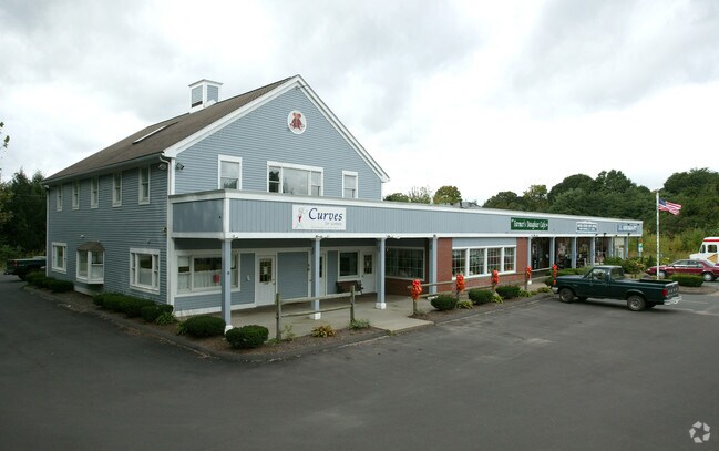

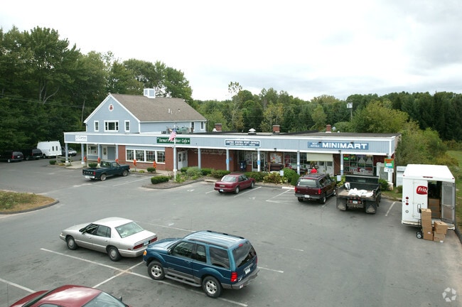
Property Detail
1365 Mountain Rd
SUFF-000016H-000024-000001
Capitol
Storebuilding
Connecticut
WSCV
1
B and X Area of moderate flood hazard, usually the area between the limits of the 100-year and 500-year floods.
2 AC
2025
Northwest Outlying
2025
Hartford
477101
Hartford-West Hartford-East Hartford, CT
9,218 SF
NEARBY LISTINGS FOR SALE OR LEASE
-
-
View all West Suffield listings for lease on LoopNet.com
DEMOGRAPHICS near 1365 Mountain Rd
1 mile
3 mile
5 mile
2025 Total Population
673
6,899
31,865
2030 Population
689
7,067
32,456
Pop Growth 2025-2030
+ 2.38%
+ 2.44%
+ 1.85%
Average Age
44
44
44
2025 Total Households
263
2,577
12,152
HH Growth 2025-2030
+ 2.66%
+ 2.52%
+ 1.84%
Median Household Inc
$124,038
$124,866
$111,094
Avg Household Size
2.50
2.50
2.40
2025 Avg HH Vehicles
2.00
2.00
2.00
Median Home Value
$398,648
$418,830
$375,365
Median Year Built
1968
1974
1974
Nearby Places
Map Layers
Map Styles
 Street
 Aerial
Layers
 Traffic
 Biking
Places
Listings with unknown addresses are not visible on the map
- Restaurants
- Banks
- Shops
- Fitness
- Groceries
PUBLIC TRANSPORTATION
COMMUTER RAIL
Windsor Locks (Hartford Line - CT Rail (CTRail))
Drive
Walk
Distance
Windsor Locks (Hartford Line - CT Rail (CTRail))
18 min
7.9 mi
AIRPORT
Bradley International
Drive
Walk
Distance
Bradley International
19 min
6.1 mi
SALE & LEASE HISTORY
LISTING DATE
SALE/LEASE

Jan 31, 2024
For Lease
Nearby Properties
Address
Land Use
TOTAL SIZE
Lot Size
Zoning
Address
Land Use
TOTAL SIZE
Lot Size
Zoning
30.30 AC
R25
Address
Land Use
TOTAL SIZE
Lot Size
Zoning
207,981 SF
60.48 AC
R45
Address
Land Use
TOTAL SIZE
Lot Size
Zoning
32.40 AC
R90
Address
Land Use
TOTAL SIZE
Lot Size
Zoning
64.46 AC
R25
Address
Land Use
TOTAL SIZE
Lot Size
Zoning
135,228 SF
19.50 AC
R45
Address
Land Use
TOTAL SIZE
Lot Size
Zoning
10 AC
R45
Address
Land Use
TOTAL SIZE
Lot Size
Zoning
92,900 SF
20.84 AC
PDIP
Address
Land Use
TOTAL SIZE
Lot Size
Zoning
99.10 AC
R25
Address
Land Use
TOTAL SIZE
Lot Size
Zoning
25.91 AC
R45
Address
Land Use
TOTAL SIZE
Lot Size
Zoning
17,950 SF
1.30 AC
TCV
Address
Land Use
TOTAL SIZE
Lot Size
Zoning
3.49 AC
TCV
Address
Land Use
TOTAL SIZE
Lot Size
Zoning
18,880 SF
0.84 AC
TCV
Address
Land Use
TOTAL SIZE
Lot Size
Zoning
13,844 SF
2.09 AC
TCV
Address
Land Use
TOTAL SIZE
Lot Size
Zoning
15,188 SF
1.50 AC
R45
Address
Land Use
TOTAL SIZE
Lot Size
Zoning
1.21 AC
TCV
Address
Land Use
TOTAL SIZE
Lot Size
Zoning
69,919 SF
6.23 AC
TCV
Address
Land Use
TOTAL SIZE
Lot Size
Zoning
10.20 AC
R90
Address
Land Use
TOTAL SIZE
Lot Size
Zoning
9,946 SF
1.27 AC
TCV
Address
Land Use
TOTAL SIZE
Lot Size
Zoning
2.57 AC
R25
Address
Land Use
TOTAL SIZE
Lot Size
Zoning
24.31 AC
TCV
Address
Land Use
TOTAL SIZE
Lot Size
Zoning
36,192 SF
2.51 AC
R25
Address
Land Use
TOTAL SIZE
Lot Size
Zoning
32,400 SF
2.59 AC
PDIP
Address
Land Use
TOTAL SIZE
Lot Size
Zoning
25,312 SF
4.32 AC
PDIP
Address
Land Use
TOTAL SIZE
Lot Size
Zoning
30,620 SF
4.09 AC
PDIP
Address
Land Use
TOTAL SIZE
Lot Size
Zoning
14,736 SF
2.21 AC
TCV
Address
Land Use
TOTAL SIZE
Lot Size
Zoning
2.23 AC
R25
Address
Land Use
TOTAL SIZE
Lot Size
Zoning
7,980 SF
1.18 AC
TCV
Address
Land Use
TOTAL SIZE
Lot Size
Zoning
62.70 AC
R25
Address
Land Use
TOTAL SIZE
Lot Size
Zoning
8,955 SF
2.69 AC
R45
Address
Land Use
TOTAL SIZE
Lot Size
Zoning
11,702 SF
3.27 AC
R25
The World's #1 Commercial Real Estate Marketplace
Connect with us
© 2026 CoStar Group
The information above has been obtained from sources believed reliable. While we do not doubt its accuracy we have not verified it and make no guarantee, warranty or representation about it. It is your responsibility to independently confirm its accuracy and completeness. Any projections, opinions, assumptions, or estimates used are for example only and do not represent the current or future performance of the property. The value of this transaction to you depends on tax and other factors which should be evaluated by your tax, financial, and legal advisors. You and your advisors should conduct a careful, independent investigation of the property to determine to your satisfaction the suitability of the property for your needs.