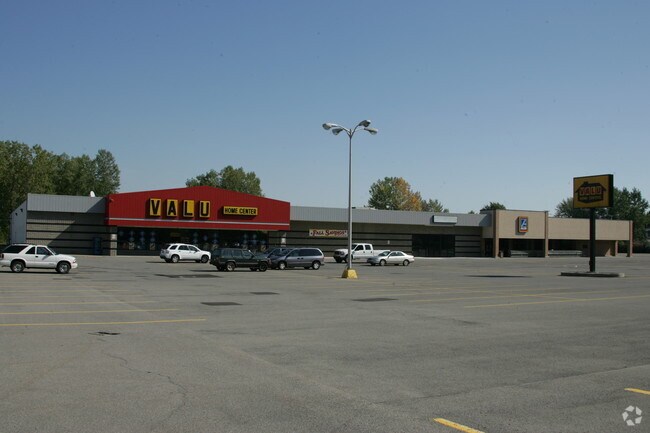
Property Record
1365 Nash Rd, North Tonawanda, NY 14120
NEARBY LISTINGS FOR SALE OR LEASE
Property Detail
1365 Nash Rd
Buffalo-Cheektowaga, NY
Niagara
291200-176-014-0005-064-001
New York
Stripcommercialcenter
3.30 AC
X
North
36063C0361E
Buffalo/Niagara Falls
58,800 SF
DEMOGRAPHICS near 1365 Nash Rd
1 Mile
3 Mile
5 Mile
2024 Total Population
9,039
45,859
113,446
2029 Population
8,878
45,003
112,218
Pop Growth 2024-2029
(1.78%)
(1.87%)
(1.08%)
Average Age
45
43
43
2024 Total Households
3,763
20,207
50,171
HH Growth 2024-2029
(1.86%)
(1.93%)
(1.11%)
Median Household Inc
$78,584
$70,915
$68,366
Avg Household Size
2.40
2.20
2.20
2024 Avg HH Vehicles
2.00
2.00
2.00
Median Home Value
$174,620
$181,582
$184,095
Median Year Built
1964
1958
1962
Nearby Places
Map Layers
Map Styles
 Street
 Aerial
- Restaurants
- Banks
- Shops
- Fitness
- Groceries
PUBLIC TRANSPORTATION
AIRPORT
Niagara Falls International
DRIVE
WALK
Distance
Niagara Falls International
11 min
5.7 mi
Buffalo Niagara International
DRIVE
WALK
Distance
Buffalo Niagara International
25 min
13.9 mi
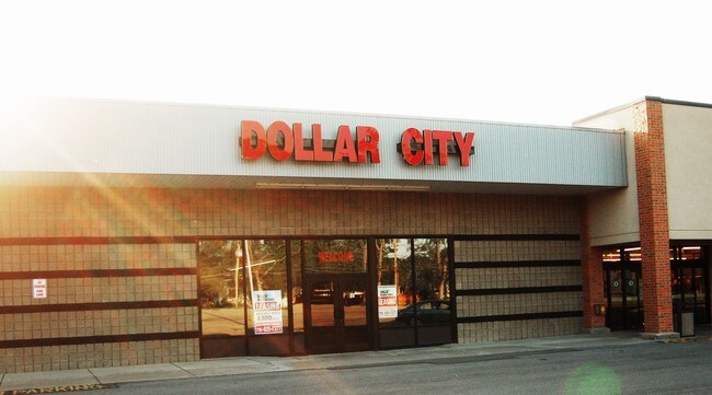
SALE & LEASE HISTORY
LISTING DATE
SALE/LEASE

Nov 16, 2016
For Lease
Nearby Properties
Address
Land Use
TOTAL SIZE
Lot Size
Zoning
Address
Land Use
TOTAL SIZE
Lot Size
Zoning
5,472 SF
70.10 AC
Address
Land Use
TOTAL SIZE
Lot Size
Zoning
223,916 SF
8.25 AC
R-C
Address
Land Use
TOTAL SIZE
Lot Size
Zoning
4,707 SF
13.60 AC
WD NT
Address
Land Use
TOTAL SIZE
Lot Size
Zoning
11,248 SF
21.70 AC
MFR-5
Address
Land Use
TOTAL SIZE
Lot Size
Zoning
173,303 SF
24.40 AC
R1-2
Address
Land Use
TOTAL SIZE
Lot Size
Zoning
112,256 SF
38.33 AC
00000
Address
Land Use
TOTAL SIZE
Lot Size
Zoning
96,554 SF
10.90 AC
Address
Land Use
TOTAL SIZE
Lot Size
Zoning
67,000 SF
6.50 AC
Address
Land Use
TOTAL SIZE
Lot Size
Zoning
137,878 SF
23.60 AC
R1-2
Address
Land Use
TOTAL SIZE
Lot Size
Zoning
81,224 SF
0.45 AC
Address
Land Use
TOTAL SIZE
Lot Size
Zoning
Address
Land Use
TOTAL SIZE
Lot Size
Zoning
Address
Land Use
TOTAL SIZE
Lot Size
Zoning
175,793 SF
27.30 AC
M-1
Address
Land Use
TOTAL SIZE
Lot Size
Zoning
137,200 SF
3.56 AC
WD
Address
Land Use
TOTAL SIZE
Lot Size
Zoning
28,448 SF
4.30 AC
GB
Address
Land Use
TOTAL SIZE
Lot Size
Zoning
1,323 SF
26.39 AC
R-2
Address
Land Use
TOTAL SIZE
Lot Size
Zoning
96,458 SF
7.94 AC
GB
Address
Land Use
TOTAL SIZE
Lot Size
Zoning
57,000 SF
4.02 AC
Address
Land Use
TOTAL SIZE
Lot Size
Zoning
47,400 SF
10.03 AC
MS
Address
Land Use
TOTAL SIZE
Lot Size
Zoning
34,100 SF
15.75 AC
C-1
Address
Land Use
TOTAL SIZE
Lot Size
Zoning
51,232 SF
2.55 AC
WD
Address
Land Use
TOTAL SIZE
Lot Size
Zoning
51,232 SF
1.62 AC
WD
Address
Land Use
TOTAL SIZE
Lot Size
Zoning
217,735 SF
34.80 AC
Address
Land Use
TOTAL SIZE
Lot Size
Zoning
39,654 SF
4.33 AC
R-2
Address
Land Use
TOTAL SIZE
Lot Size
Zoning
8.20 AC
R2
Address
Land Use
TOTAL SIZE
Lot Size
Zoning
60,985 SF
4.38 AC
C-1
Address
Land Use
TOTAL SIZE
Lot Size
Zoning
154,516 SF
29.20 AC
Address
Land Use
TOTAL SIZE
Lot Size
Zoning
64,815 SF
5.90 AC
Address
Land Use
TOTAL SIZE
Lot Size
Zoning
36,005 SF
0.83 AC
Address
Land Use
TOTAL SIZE
Lot Size
Zoning
56,570 SF
6.20 AC
The World's #1 Commercial Real Estate Marketplace
Connect with us
© 2026 CoStar Group
The information above has been obtained from sources believed reliable. While we do not doubt its accuracy we have not verified it and make no guarantee, warranty or representation about it. It is your responsibility to independently confirm its accuracy and completeness. Any projections, opinions, assumptions, or estimates used are for example only and do not represent the current or future performance of the property. The value of this transaction to you depends on tax and other factors which should be evaluated by your tax, financial, and legal advisors. You and your advisors should conduct a careful, independent investigation of the property to determine to your satisfaction the suitability of the property for your needs.