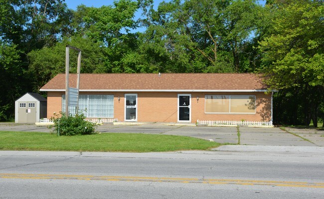
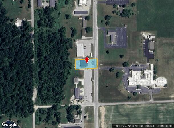
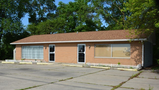
Property Record
1366 S Randolph St, Garrett, IN 46738
NEARBY LISTINGS FOR SALE OR LEASE
-
-
View all Garrett listings for sale on LoopNet.com
Property Detail
1366 S Randolph St
17-09-10-151-006.000-013
SW1/4 NW1/4 SECTION 10 TWP 33 RANGE 12 ACRES 0.5200
Storebuilding
Dekalb
X
Indiana
18113C0375D
0.52 AC
2024
Fort Wayne
2024
Other Market Areas
020601
Auburn, IN
2,622 SF
DEMOGRAPHICS near 1366 S Randolph St
1 Mile
3 Mile
5 Mile
2024 Total Population
2,359
8,287
17,503
2029 Population
2,418
8,490
17,919
Pop Growth 2024-2029
+ 2.50%
+ 2.45%
+ 2.38%
Average Age
40
38
39
2024 Total Households
892
3,167
6,886
HH Growth 2024-2029
+ 2.47%
+ 2.43%
+ 2.40%
Median Household Inc
$56,986
$54,243
$54,625
Avg Household Size
2.60
2.50
2.50
2024 Avg HH Vehicles
2.00
2.00
2.00
Median Home Value
$158,233
$149,948
$148,221
Median Year Built
1970
1966
1970
Nearby Places
Map Layers
Map Styles
 Street
 Aerial
- Restaurants
- Banks
- Shops
- Fitness
- Groceries
PUBLIC TRANSPORTATION
AIRPORT
Fort Wayne International
DRIVE
WALK
Distance
Fort Wayne International
47 min
35.2 mi
Freight Ports
Port of Toledo
DRIVE
WALK
Distance
Port of Toledo
144 min
112.7 mi
SALE & LEASE HISTORY
LISTING DATE
SALE/LEASE

Jun 21, 2019
For Sale
Nearby Properties
Address
Land Use
TOTAL SIZE
Lot Size
Zoning
Address
Land Use
TOTAL SIZE
Lot Size
Zoning
406,797 SF
158.80 AC
Address
Land Use
TOTAL SIZE
Lot Size
Zoning
320,870 SF
106.40 AC
Address
Land Use
TOTAL SIZE
Lot Size
Zoning
12,000 SF
159.44 AC
Address
Land Use
TOTAL SIZE
Lot Size
Zoning
123,126 SF
15 AC
Address
Land Use
TOTAL SIZE
Lot Size
Zoning
46,800 SF
1.20 AC
Address
Land Use
TOTAL SIZE
Lot Size
Zoning
58,800 SF
7.33 AC
Address
Land Use
TOTAL SIZE
Lot Size
Zoning
5,805 SF
8.10 AC
Address
Land Use
TOTAL SIZE
Lot Size
Zoning
39,000 SF
8.49 AC
Address
Land Use
TOTAL SIZE
Lot Size
Zoning
8,040 SF
9.16 AC
Address
Land Use
TOTAL SIZE
Lot Size
Zoning
189,360 SF
21.90 AC
Address
Land Use
TOTAL SIZE
Lot Size
Zoning
25,800 SF
9.02 AC
Address
Land Use
TOTAL SIZE
Lot Size
Zoning
7,200 SF
12 AC
Address
Land Use
TOTAL SIZE
Lot Size
Zoning
85,202 SF
15.30 AC
Address
Land Use
TOTAL SIZE
Lot Size
Zoning
37.04 AC
Address
Land Use
TOTAL SIZE
Lot Size
Zoning
6,400 SF
12.79 AC
Address
Land Use
TOTAL SIZE
Lot Size
Zoning
22,875 SF
3.74 AC
Address
Land Use
TOTAL SIZE
Lot Size
Zoning
100,500 SF
13.27 AC
Address
Land Use
TOTAL SIZE
Lot Size
Zoning
28,169 SF
6.87 AC
Address
Land Use
TOTAL SIZE
Lot Size
Zoning
9,400 SF
1.33 AC
Address
Land Use
TOTAL SIZE
Lot Size
Zoning
26,940 SF
3.04 AC
Address
Land Use
TOTAL SIZE
Lot Size
Zoning
11,100 SF
0.83 AC
Address
Land Use
TOTAL SIZE
Lot Size
Zoning
17,250 SF
4.73 AC
Address
Land Use
TOTAL SIZE
Lot Size
Zoning
4,800 SF
14.46 AC
Address
Land Use
TOTAL SIZE
Lot Size
Zoning
30,000 SF
5 AC
Address
Land Use
TOTAL SIZE
Lot Size
Zoning
1,776 SF
72.54 AC
Address
Land Use
TOTAL SIZE
Lot Size
Zoning
1,408 SF
7.84 AC
Address
Land Use
TOTAL SIZE
Lot Size
Zoning
13,340 SF
3.39 AC
Address
Land Use
TOTAL SIZE
Lot Size
Zoning
9,360 SF
19.14 AC
Address
Land Use
TOTAL SIZE
Lot Size
Zoning
6,000 SF
3.73 AC
Address
Land Use
TOTAL SIZE
Lot Size
Zoning
18,000 SF
4.11 AC
The World's #1 Commercial Real Estate Marketplace
Connect with us
© 2025 CoStar Group
The information above has been obtained from sources believed reliable. While we do not doubt its accuracy we have not verified it and make no guarantee, warranty or representation about it. It is your responsibility to independently confirm its accuracy and completeness. Any projections, opinions, assumptions, or estimates used are for example only and do not represent the current or future performance of the property. The value of this transaction to you depends on tax and other factors which should be evaluated by your tax, financial, and legal advisors. You and your advisors should conduct a careful, independent investigation of the property to determine to your satisfaction the suitability of the property for your needs.