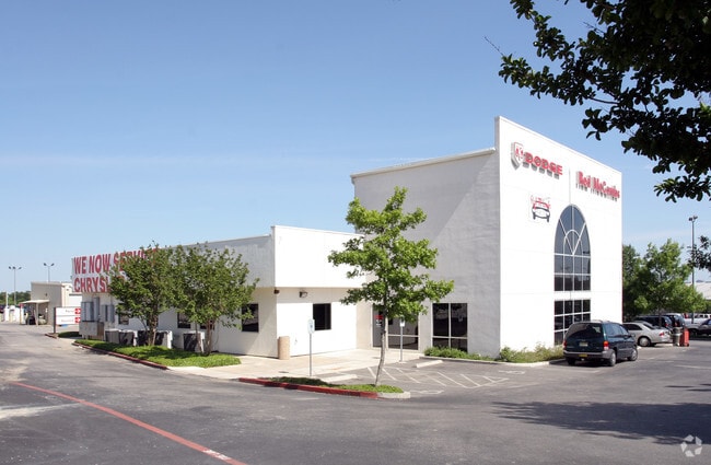
Property Record
13663 W Interstate 10, San Antonio, TX 78249

Save to a Folder
{{folder.Name}}
{{folder.ListingIds.length}} Properties
{{folder.ListingIds.length}} Property
Create a New Folder
Property Detail
13663 W Interstate 10
San Antonio-New Braunfels, TX
NCB 15825 BLK 9 LOT 21 MCCOMBS FAMILY LTD. SUBD
15825-009-0210
BEXAR
Vehiclerentalsvehiclesales
Texas
B and X Area of moderate flood hazard, usually the area between the limits of the 100-year and 500-year floods.
21
2025
4.93 AC
2025
Northwest
181814
San Antonio
24,365 SF
NEARBY LISTINGS FOR SALE OR LEASE
DEMOGRAPHICS near 13663 W Interstate 10
1 mile
3 mile
5 mile
2025 Total Population
11,805
96,922
265,041
2030 Population
12,576
102,390
278,838
Pop Growth 2025-2030
+ 6.53%
+ 5.64%
+ 5.21%
Average Age
33
36
37
2025 Total Households
5,652
42,401
114,697
HH Growth 2025-2030
+ 6.90%
+ 6.02%
+ 5.50%
Median Household Inc
$69,543
$71,227
$72,226
Avg Household Size
1.90
2.20
2.20
2025 Avg HH Vehicles
2.00
2.00
2.00
Median Home Value
$326,988
$339,221
$355,303
Median Year Built
2009
1998
1994
Nearby Places
Map Layers
Map Styles
 Street
 Aerial
Layers
 Traffic
 Biking
Places
Listings with unknown addresses are not visible on the map
- Restaurants
- Banks
- Shops
- Fitness
- Groceries
PUBLIC TRANSPORTATION
AIRPORT
San Antonio International
Drive
Walk
Distance
San Antonio International
16 min
11.3 mi
Freight Ports
Calhoun Port
Drive
Walk
Distance
Calhoun Port
196 min
164.7 mi
Nearby Properties
Address
Land Use
TOTAL SIZE
Lot Size
Zoning
Address
Land Use
TOTAL SIZE
Lot Size
Zoning
437,060 SF
91.31 AC
Address
Land Use
TOTAL SIZE
Lot Size
Zoning
405,133 SF
16.41 AC
Address
Land Use
TOTAL SIZE
Lot Size
Zoning
538,895 SF
54.58 AC
Address
Land Use
TOTAL SIZE
Lot Size
Zoning
335,841 SF
33.70 AC
Address
Land Use
TOTAL SIZE
Lot Size
Zoning
4,465,972 SF
231.60 AC
Address
Land Use
TOTAL SIZE
Lot Size
Zoning
538,895 SF
60.25 AC
Address
Land Use
TOTAL SIZE
Lot Size
Zoning
509,312 SF
43.63 AC
Address
Land Use
TOTAL SIZE
Lot Size
Zoning
391,367 SF
11.36 AC
Address
Land Use
TOTAL SIZE
Lot Size
Zoning
940,089 SF
63.74 AC
Address
Land Use
TOTAL SIZE
Lot Size
Zoning
499,480 SF
19.57 AC
Address
Land Use
TOTAL SIZE
Lot Size
Zoning
227,586 SF
25.46 AC
Address
Land Use
TOTAL SIZE
Lot Size
Zoning
21,348 SF
14.50 AC
Address
Land Use
TOTAL SIZE
Lot Size
Zoning
462,227 SF
31.21 AC
Address
Land Use
TOTAL SIZE
Lot Size
Zoning
13,128 SF
5.23 AC
Address
Land Use
TOTAL SIZE
Lot Size
Zoning
300,264 SF
27.81 AC
Address
Land Use
TOTAL SIZE
Lot Size
Zoning
21,852 SF
5.25 AC
Address
Land Use
TOTAL SIZE
Lot Size
Zoning
331,715 SF
9.04 AC
Address
Land Use
TOTAL SIZE
Lot Size
Zoning
10,622 SF
8.01 AC
Address
Land Use
TOTAL SIZE
Lot Size
Zoning
389,048 SF
16.25 AC
Address
Land Use
TOTAL SIZE
Lot Size
Zoning
329,050 SF
17.10 AC
Address
Land Use
TOTAL SIZE
Lot Size
Zoning
320,406 SF
12.11 AC
Address
Land Use
TOTAL SIZE
Lot Size
Zoning
515,812 SF
200.45 AC
Address
Land Use
TOTAL SIZE
Lot Size
Zoning
305,497 SF
9.99 AC
Address
Land Use
TOTAL SIZE
Lot Size
Zoning
395,039 SF
31 AC
Address
Land Use
TOTAL SIZE
Lot Size
Zoning
6,809 SF
9.04 AC
Address
Land Use
TOTAL SIZE
Lot Size
Zoning
238,999 SF
8.43 AC
Address
Land Use
TOTAL SIZE
Lot Size
Zoning
724,148 SF
18.70 AC
Address
Land Use
TOTAL SIZE
Lot Size
Zoning
306,959 SF
15.24 AC
Address
Land Use
TOTAL SIZE
Lot Size
Zoning
309,429 SF
5.17 AC
Address
Land Use
TOTAL SIZE
Lot Size
Zoning
309,901 SF
15.46 AC
The World's #1 Commercial Real Estate Marketplace
Connect with us
© 2026 CoStar Group
The information above has been obtained from sources believed reliable. While we do not doubt its accuracy we have not verified it and make no guarantee, warranty or representation about it. It is your responsibility to independently confirm its accuracy and completeness. Any projections, opinions, assumptions, or estimates used are for example only and do not represent the current or future performance of the property. The value of this transaction to you depends on tax and other factors which should be evaluated by your tax, financial, and legal advisors. You and your advisors should conduct a careful, independent investigation of the property to determine to your satisfaction the suitability of the property for your needs.