Property Record
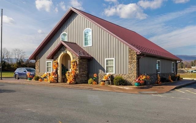
13665 Spotswood Trl, Elkton, VA 22827


NEARBY LISTINGS FOR SALE OR LEASE
-
-
View all Elkton listings for sale on LoopNet.com
Property Detail
13665 Spotswood Trl
129-A-L179A1
Division Of Daniel W Brubaker Land
Commercialnec
Rockingham
X
Virginia
51165C0445D
8.65 AC
2025
Staunton & Harrisonburg
2025
Other Market Areas
010301
Harrisonburg, VA
18,970 SF
DEMOGRAPHICS near 13665 Spotswood Trl
1 Mile
3 Mile
5 Mile
2024 Total Population
438
5,530
12,381
2029 Population
450
5,740
12,934
Pop Growth 2024-2029
+ 2.74%
+ 3.80%
+ 4.47%
Average Age
43
43
43
2024 Total Households
173
2,218
5,016
HH Growth 2024-2029
+ 2.89%
+ 3.74%
+ 4.47%
Median Household Inc
$68,437
$73,377
$74,346
Avg Household Size
2.50
2.40
2.40
2024 Avg HH Vehicles
2.00
2.00
2.00
Median Home Value
$269,148
$252,408
$259,663
Median Year Built
1988
1982
1984
Nearby Places
Map Layers
Map Styles
 Street
 Aerial
- Restaurants
- Banks
- Shops
- Fitness
- Groceries
PUBLIC TRANSPORTATION
AIRPORT
Charlottesville-Albemarle
DRIVE
WALK
Distance
Charlottesville-Albemarle
47 min
32.7 mi
Freight Ports
Virginia Port Authority - Richmond
DRIVE
WALK
Distance
Virginia Port Authority - Richmond
141 min
109.1 mi
SALE & LEASE HISTORY
LISTING DATE
SALE/LEASE

Nov 20, 2024
For Sale
Nearby Properties
Address
Land Use
TOTAL SIZE
Lot Size
Zoning
Address
Land Use
TOTAL SIZE
Lot Size
Zoning
169.25 AC
I1
Address
Land Use
TOTAL SIZE
Lot Size
Zoning
91,860 SF
55 AC
A2
Address
Land Use
TOTAL SIZE
Lot Size
Zoning
52.38 AC
R4
Address
Land Use
TOTAL SIZE
Lot Size
Zoning
138.50 AC
R5
Address
Land Use
TOTAL SIZE
Lot Size
Zoning
68,292 SF
2.41 AC
R3
Address
Land Use
TOTAL SIZE
Lot Size
Zoning
94,782 SF
10.35 AC
B2
Address
Land Use
TOTAL SIZE
Lot Size
Zoning
3,147 SF
26.02 AC
A2
Address
Land Use
TOTAL SIZE
Lot Size
Zoning
1,824 SF
2.58 AC
A2
Address
Land Use
TOTAL SIZE
Lot Size
Zoning
52,065 SF
8.08 AC
M1
Address
Land Use
TOTAL SIZE
Lot Size
Zoning
12,470 SF
9.99 AC
A1
Address
Land Use
TOTAL SIZE
Lot Size
Zoning
13,110 SF
3 AC
B1
Address
Land Use
TOTAL SIZE
Lot Size
Zoning
13,294 SF
1.36 AC
A2
Address
Land Use
TOTAL SIZE
Lot Size
Zoning
129,968 SF
8.71 AC
B2
Address
Land Use
TOTAL SIZE
Lot Size
Zoning
15,000 SF
20.52 AC
I1
Address
Land Use
TOTAL SIZE
Lot Size
Zoning
3 AC
R3
Address
Land Use
TOTAL SIZE
Lot Size
Zoning
376.65 AC
A1
Address
Land Use
TOTAL SIZE
Lot Size
Zoning
24,636 SF
155.58 AC
A1
Address
Land Use
TOTAL SIZE
Lot Size
Zoning
13,440 SF
2.68 AC
R2
Address
Land Use
TOTAL SIZE
Lot Size
Zoning
24,233 SF
8 AC
B1
Address
Land Use
TOTAL SIZE
Lot Size
Zoning
16,380 SF
0.61 AC
B1
Address
Land Use
TOTAL SIZE
Lot Size
Zoning
26,996 SF
21.72 AC
M2
Address
Land Use
TOTAL SIZE
Lot Size
Zoning
23,844 SF
6.43 AC
A1
Address
Land Use
TOTAL SIZE
Lot Size
Zoning
48,612 SF
3.95 AC
B1
Address
Land Use
TOTAL SIZE
Lot Size
Zoning
23,960 SF
8.92 AC
A2
Address
Land Use
TOTAL SIZE
Lot Size
Zoning
9,486 SF
1.12 AC
B2
Address
Land Use
TOTAL SIZE
Lot Size
Zoning
20,472 SF
1.17 AC
B1
Address
Land Use
TOTAL SIZE
Lot Size
Zoning
3,955 SF
3.82 AC
B2
Address
Land Use
TOTAL SIZE
Lot Size
Zoning
10,035 SF
0.30 AC
B1
The World's #1 Commercial Real Estate Marketplace
Connect with us
© 2026 CoStar Group
The information above has been obtained from sources believed reliable. While we do not doubt its accuracy we have not verified it and make no guarantee, warranty or representation about it. It is your responsibility to independently confirm its accuracy and completeness. Any projections, opinions, assumptions, or estimates used are for example only and do not represent the current or future performance of the property. The value of this transaction to you depends on tax and other factors which should be evaluated by your tax, financial, and legal advisors. You and your advisors should conduct a careful, independent investigation of the property to determine to your satisfaction the suitability of the property for your needs.