Property Record
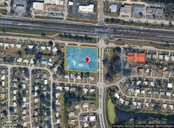
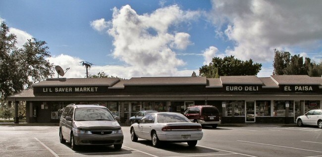
13680 Tamiami Trl, North Port, FL 34287

NEARBY LISTINGS FOR SALE OR LEASE
Property Detail
13680 Tamiami Trl
0997-00-0732
Port Charlotte Sub
Storemultistory
TRACT H BLK 7 PORT CHARLOTTE SUB CARD 1 TENANTS;
AE
Sarasota
12115C0386G
Florida
2024
2.75 AC
2025
Sarasota Outlying
002723
Tampa/St Petersburg
11,456 SF
North Port-Sarasota-Bradenton, FL
DEMOGRAPHICS near 13680 Tamiami Trl
1 Mile
3 Mile
5 Mile
2024 Total Population
7,519
30,001
60,932
2029 Population
8,582
34,493
70,272
Pop Growth 2024-2029
+ 14.14%
+ 14.97%
+ 15.33%
Average Age
47
51
48
2024 Total Households
3,361
13,648
25,544
HH Growth 2024-2029
+ 14.10%
+ 15.05%
+ 15.46%
Median Household Inc
$46,143
$56,505
$63,157
Avg Household Size
2.20
2.10
2.30
2024 Avg HH Vehicles
1.00
2.00
2.00
Median Home Value
$173,865
$201,645
$238,881
Median Year Built
1976
1988
1999
Nearby Places
Map Layers
Map Styles
 Street
 Aerial
- Restaurants
- Banks
- Shops
- Fitness
- Groceries
PUBLIC TRANSPORTATION
AIRPORT
Punta Gorda
DRIVE
WALK
Distance
Punta Gorda
35 min
19.4 mi
Freight Ports
Port Manatee
DRIVE
WALK
Distance
Port Manatee
68 min
52.3 mi
SALE & LEASE HISTORY
LISTING DATE
SALE/LEASE

Jan 23, 2018
For Lease
Nearby Properties
Address
Land Use
TOTAL SIZE
Lot Size
Zoning
Address
Land Use
TOTAL SIZE
Lot Size
Zoning
548,781 SF
196.98 AC
GU
Address
Land Use
TOTAL SIZE
Lot Size
Zoning
267,412 SF
23.26 AC
AC1
Address
Land Use
TOTAL SIZE
Lot Size
Zoning
302,632 SF
15.71 AC
AC2
Address
Land Use
TOTAL SIZE
Lot Size
Zoning
205,624 SF
21.37 AC
AC1
Address
Land Use
TOTAL SIZE
Lot Size
Zoning
103,327 SF
47.54 AC
GU
Address
Land Use
TOTAL SIZE
Lot Size
Zoning
101,676 SF
8.83 AC
AC1
Address
Land Use
TOTAL SIZE
Lot Size
Zoning
79,944 SF
15.64 AC
AC1
Address
Land Use
TOTAL SIZE
Lot Size
Zoning
155,080 SF
8.96 AC
CG
Address
Land Use
TOTAL SIZE
Lot Size
Zoning
196,163 SF
15.60 AC
AC1
Address
Land Use
TOTAL SIZE
Lot Size
Zoning
142,364 SF
13.87 AC
AC1
Address
Land Use
TOTAL SIZE
Lot Size
Zoning
40,161 SF
40 AC
GU
Address
Land Use
TOTAL SIZE
Lot Size
Zoning
65,103 SF
10.16 AC
AC2
Address
Land Use
TOTAL SIZE
Lot Size
Zoning
85,529 SF
11.41 AC
AC1
Address
Land Use
TOTAL SIZE
Lot Size
Zoning
105,046 SF
12.69 AC
AC1
Address
Land Use
TOTAL SIZE
Lot Size
Zoning
115,678 SF
8.58 AC
R3
Address
Land Use
TOTAL SIZE
Lot Size
Zoning
42,923 SF
403.06 AC
R1
Address
Land Use
TOTAL SIZE
Lot Size
Zoning
63,016 SF
2.56 AC
AC1
Address
Land Use
TOTAL SIZE
Lot Size
Zoning
14,714 SF
81.28 AC
AC7B
Address
Land Use
TOTAL SIZE
Lot Size
Zoning
289,861 SF
27.47 AC
AC2
Address
Land Use
TOTAL SIZE
Lot Size
Zoning
17.48 AC
AC1
Address
Land Use
TOTAL SIZE
Lot Size
Zoning
29,890 SF
7.78 AC
R3
Address
Land Use
TOTAL SIZE
Lot Size
Zoning
55,685 SF
6.15 AC
COR
Address
Land Use
TOTAL SIZE
Lot Size
Zoning
41,054 SF
5.66 AC
CNP
Address
Land Use
TOTAL SIZE
Lot Size
Zoning
54.56 AC
AC1
Address
Land Use
TOTAL SIZE
Lot Size
Zoning
50,032 SF
10.06 AC
AC1
Address
Land Use
TOTAL SIZE
Lot Size
Zoning
26,467 SF
5.02 AC
GU
Address
Land Use
TOTAL SIZE
Lot Size
Zoning
37,448 SF
4.15 AC
AC1
Address
Land Use
TOTAL SIZE
Lot Size
Zoning
15.45 AC
AC9
Address
Land Use
TOTAL SIZE
Lot Size
Zoning
33,313 SF
3.93 AC
CG
Address
Land Use
TOTAL SIZE
Lot Size
Zoning
19,360 SF
2.28 AC
AC1
The World's #1 Commercial Real Estate Marketplace
Connect with us
© 2025 CoStar Group
The information above has been obtained from sources believed reliable. While we do not doubt its accuracy we have not verified it and make no guarantee, warranty or representation about it. It is your responsibility to independently confirm its accuracy and completeness. Any projections, opinions, assumptions, or estimates used are for example only and do not represent the current or future performance of the property. The value of this transaction to you depends on tax and other factors which should be evaluated by your tax, financial, and legal advisors. You and your advisors should conduct a careful, independent investigation of the property to determine to your satisfaction the suitability of the property for your needs.