Property Record
1369 N Hampton Rd, Desoto, TX 75115
NEARBY LISTINGS FOR SALE OR LEASE
-
-
View all Desoto listings for sale on LoopNet.com
Property Detail
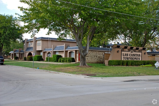
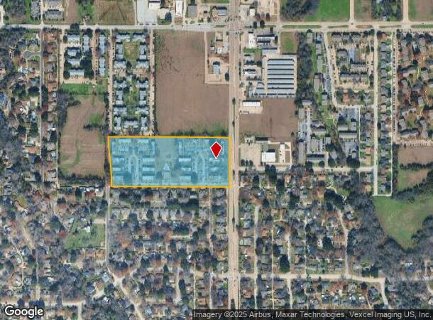
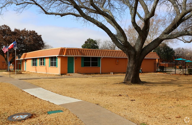
1369 N Hampton Rd
Dallas-Fort Worth-Arlington, TX
Las Casitas
20058500010010000
LAS CASITAS BLK 1 LT 1 ACS 11.705 INT202000283584 DD10142020 CO-DC 0585000100100 5CS05850001
Apartment
Dallas
X
Texas
48139C0055G
1
2024
11.71 AC
2025
South Dallas County
016618
Dallas/Ft Worth
125,586 SF
DEMOGRAPHICS near 1369 N Hampton Rd
1 Mile
3 Mile
5 Mile
2024 Total Population
9,003
73,422
202,217
2029 Population
8,891
72,439
199,766
Pop Growth 2024-2029
(1.24%)
(1.34%)
(1.21%)
Average Age
41
39
37
2024 Total Households
3,497
26,520
70,129
HH Growth 2024-2029
(1.46%)
(1.58%)
(1.42%)
Median Household Inc
$59,392
$63,625
$60,786
Avg Household Size
2.50
2.70
2.80
2024 Avg HH Vehicles
2.00
2.00
2.00
Median Home Value
$250,649
$231,314
$215,965
Median Year Built
1986
1988
1986
Nearby Places
Map Layers
Map Styles
 Street
 Aerial
- Restaurants
- Banks
- Shops
- Fitness
- Groceries
PUBLIC TRANSPORTATION
AIRPORT
Dallas Love Field
DRIVE
WALK
Distance
Dallas Love Field
31 min
18.5 mi
Dallas-Fort Worth International
DRIVE
WALK
Distance
Dallas-Fort Worth International
40 min
29.9 mi
Freight Ports
Port of Shreveport
DRIVE
WALK
Distance
Port of Shreveport
218 min
201.4 mi
Nearby Properties
Address
Land Use
TOTAL SIZE
Lot Size
Zoning
Address
Land Use
TOTAL SIZE
Lot Size
Zoning
726,662 SF
44.94 AC
Z239
Address
Land Use
TOTAL SIZE
Lot Size
Zoning
1,316,325 SF
54.36 AC
Z111
Address
Land Use
TOTAL SIZE
Lot Size
Zoning
1,126,320 SF
63.41 AC
Z111
Address
Land Use
TOTAL SIZE
Lot Size
Zoning
1,167,500 SF
46.04 AC
Z06
Address
Land Use
TOTAL SIZE
Lot Size
Zoning
951,480 SF
50.63 AC
Z109
Address
Land Use
TOTAL SIZE
Lot Size
Zoning
948,392 SF
50.80 AC
Z109
Address
Land Use
TOTAL SIZE
Lot Size
Zoning
872,640 SF
46.97 AC
Z125
Address
Land Use
TOTAL SIZE
Lot Size
Zoning
823,000 SF
45.10 AC
Z298
Address
Land Use
TOTAL SIZE
Lot Size
Zoning
662,230 SF
38.49 AC
Z248
Address
Land Use
TOTAL SIZE
Lot Size
Zoning
595,148 SF
34.96 AC
Z39
Address
Land Use
TOTAL SIZE
Lot Size
Zoning
123,880 SF
16.80 AC
Z236
Address
Land Use
TOTAL SIZE
Lot Size
Zoning
610,806 SF
33.66 AC
Z125
Address
Land Use
TOTAL SIZE
Lot Size
Zoning
610,806 SF
34.20 AC
Z125
Address
Land Use
TOTAL SIZE
Lot Size
Zoning
507,318 SF
28.40 AC
Z111
Address
Land Use
TOTAL SIZE
Lot Size
Zoning
552,200 SF
41.36 AC
Z109
Address
Land Use
TOTAL SIZE
Lot Size
Zoning
610,669 SF
41.65 AC
Z125
Address
Land Use
TOTAL SIZE
Lot Size
Zoning
489,310 SF
33.91 AC
Z111
Address
Land Use
TOTAL SIZE
Lot Size
Zoning
531,254 SF
33.40 AC
Z06
Address
Land Use
TOTAL SIZE
Lot Size
Zoning
227,423 SF
13.86 AC
Z236
Address
Land Use
TOTAL SIZE
Lot Size
Zoning
281,669 SF
16.02 AC
Z312
Address
Land Use
TOTAL SIZE
Lot Size
Zoning
453,600 SF
29.54 AC
Z236
Address
Land Use
TOTAL SIZE
Lot Size
Zoning
421,890 SF
23.95 AC
Z111
Address
Land Use
TOTAL SIZE
Lot Size
Zoning
406,400 SF
22.15 AC
Z125
Address
Land Use
TOTAL SIZE
Lot Size
Zoning
400,000 SF
24.69 AC
Z116
Address
Land Use
TOTAL SIZE
Lot Size
Zoning
253,794 SF
10.23 AC
Z201
Address
Land Use
TOTAL SIZE
Lot Size
Zoning
222,576 SF
35.20 AC
Z239
Address
Land Use
TOTAL SIZE
Lot Size
Zoning
418,511 SF
20.38 AC
Z111
Address
Land Use
TOTAL SIZE
Lot Size
Zoning
350,904 SF
18.46 AC
Z111
Address
Land Use
TOTAL SIZE
Lot Size
Zoning
346,500 SF
22.27 AC
Z125
Address
Land Use
TOTAL SIZE
Lot Size
Zoning
305,727 SF
25.02 AC
Z06
The World's #1 Commercial Real Estate Marketplace
Connect with us
© 2025 CoStar Group
The information above has been obtained from sources believed reliable. While we do not doubt its accuracy we have not verified it and make no guarantee, warranty or representation about it. It is your responsibility to independently confirm its accuracy and completeness. Any projections, opinions, assumptions, or estimates used are for example only and do not represent the current or future performance of the property. The value of this transaction to you depends on tax and other factors which should be evaluated by your tax, financial, and legal advisors. You and your advisors should conduct a careful, independent investigation of the property to determine to your satisfaction the suitability of the property for your needs.