Property Record
1369 Soco Rd, Maggie Valley, NC 28751
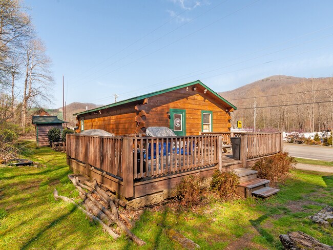

This Property Is For Sale
Property Detail
1369 Soco Rd
7696-47-7855
1369 SOCO RD
Officebuilding
Haywood
MC1
North Carolina
B and X Area of moderate flood hazard, usually the area between the limits of the 100-year and 500-year floods.
0.39 AC
2024
Haywood County
2025
Asheville
920701
Waynesville, NC
912 SF
NEARBY LISTINGS FOR SALE OR LEASE
DEMOGRAPHICS near 1369 Soco Rd
1 mile
3 mile
5 mile
2025 Total Population
1,478
7,393
25,649
2030 Population
1,569
7,746
26,208
Pop Growth 2025-2030
+ 6.16%
+ 4.77%
+ 2.18%
Average Age
53
52
48
2025 Total Households
737
3,585
11,848
HH Growth 2025-2030
+ 6.11%
+ 4.74%
+ 2.17%
Median Household Inc
$69,136
$66,279
$59,018
Avg Household Size
2.00
2.00
2.10
2025 Avg HH Vehicles
2.00
2.00
2.00
Median Home Value
$342,857
$333,387
$304,071
Median Year Built
1994
1991
1984
Nearby Places
Map Layers
Map Styles
 Street
 Aerial
Layers
 Traffic
 Biking
Places
Listings with unknown addresses are not visible on the map
- Restaurants
- Banks
- Shops
- Fitness
- Groceries
PUBLIC TRANSPORTATION
AIRPORT
Asheville Regional
Drive
Walk
Distance
Asheville Regional
48 min
36.9 mi
Nearby Properties
Address
Land Use
TOTAL SIZE
Lot Size
Zoning
Address
Land Use
TOTAL SIZE
Lot Size
Zoning
78,704 SF
19.74 AC
MC1
Address
Land Use
TOTAL SIZE
Lot Size
Zoning
43,995 SF
5 AC
Address
Land Use
TOTAL SIZE
Lot Size
Zoning
1,239 SF
18.07 AC
Address
Land Use
TOTAL SIZE
Lot Size
Zoning
15,735 SF
119.65 AC
MR2
Address
Land Use
TOTAL SIZE
Lot Size
Zoning
4,215 SF
86.32 AC
ENRD
Address
Land Use
TOTAL SIZE
Lot Size
Zoning
5,950 SF
3.93 AC
MC1
Address
Land Use
TOTAL SIZE
Lot Size
Zoning
14,352 SF
2.70 AC
Address
Land Use
TOTAL SIZE
Lot Size
Zoning
12,144 SF
3.05 AC
MC1
Address
Land Use
TOTAL SIZE
Lot Size
Zoning
10,212 SF
1 AC
MC1
Address
Land Use
TOTAL SIZE
Lot Size
Zoning
13,498 SF
1.20 AC
MC1
Address
Land Use
TOTAL SIZE
Lot Size
Zoning
3,413 SF
0.56 AC
ENRD
Address
Land Use
TOTAL SIZE
Lot Size
Zoning
5,000 SF
1.75 AC
MC1
Address
Land Use
TOTAL SIZE
Lot Size
Zoning
4,753 SF
3.27 AC
MC1
Address
Land Use
TOTAL SIZE
Lot Size
Zoning
12,280 SF
4.98 AC
Address
Land Use
TOTAL SIZE
Lot Size
Zoning
7,052 SF
3.35 AC
MC1
Address
Land Use
TOTAL SIZE
Lot Size
Zoning
11,400 SF
25.63 AC
Address
Land Use
TOTAL SIZE
Lot Size
Zoning
13,303 SF
1.43 AC
MC1
Address
Land Use
TOTAL SIZE
Lot Size
Zoning
19,082 SF
1.54 AC
Address
Land Use
TOTAL SIZE
Lot Size
Zoning
9,504 SF
1.22 AC
MC1
Address
Land Use
TOTAL SIZE
Lot Size
Zoning
10,110 SF
0.93 AC
MC1
Address
Land Use
TOTAL SIZE
Lot Size
Zoning
4,523 SF
3.35 AC
Address
Land Use
TOTAL SIZE
Lot Size
Zoning
1,064 SF
1.20 AC
MC1
Address
Land Use
TOTAL SIZE
Lot Size
Zoning
3,982 SF
1.81 AC
MC1
Address
Land Use
TOTAL SIZE
Lot Size
Zoning
11,712 SF
2.06 AC
MC1
Address
Land Use
TOTAL SIZE
Lot Size
Zoning
8,880 SF
1.45 AC
MC1
Address
Land Use
TOTAL SIZE
Lot Size
Zoning
5,568 SF
3.78 AC
MC1
Address
Land Use
TOTAL SIZE
Lot Size
Zoning
6,080 SF
2.01 AC
MC1
Address
Land Use
TOTAL SIZE
Lot Size
Zoning
9,020 SF
1.12 AC
MC1
Address
Land Use
TOTAL SIZE
Lot Size
Zoning
4,944 SF
1.11 AC
MC1
Address
Land Use
TOTAL SIZE
Lot Size
Zoning
4,320 SF
3.07 AC
MC1
The World's #1 Commercial Real Estate Marketplace
Connect with us
© 2026 CoStar Group
The information above has been obtained from sources believed reliable. While we do not doubt its accuracy we have not verified it and make no guarantee, warranty or representation about it. It is your responsibility to independently confirm its accuracy and completeness. Any projections, opinions, assumptions, or estimates used are for example only and do not represent the current or future performance of the property. The value of this transaction to you depends on tax and other factors which should be evaluated by your tax, financial, and legal advisors. You and your advisors should conduct a careful, independent investigation of the property to determine to your satisfaction the suitability of the property for your needs.