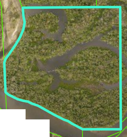
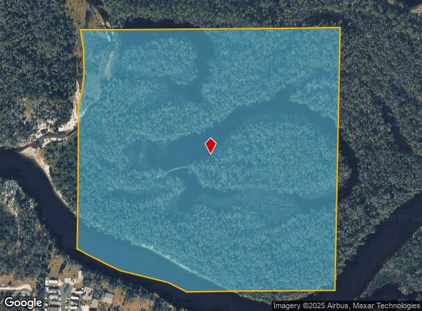
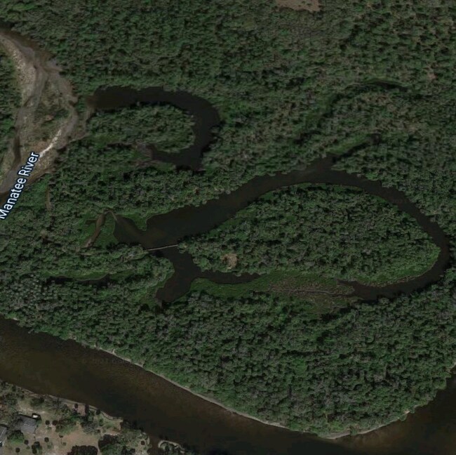
Property Record
136Th St Ne, Parrish, FL 34219
NEARBY LISTINGS FOR SALE OR LEASE
Property Detail
136Th St Ne
North Port-Bradenton-Sarasota, FL
SE 1/4 OF NE 1/4 P-2 SUBJ TO CONSERVATION EASMT PER OR2250/3223 ; LESS THAT PART LYING WITHIN EAST MANATEE FIRE RESCURE DISTRICT PI #5361.0005/9
5361-0005-9
Manatee
Vacantlandnec
Florida
0
37.92 AC
2025
Manatee Outlying
001913
Tampa/St Petersburg
DEMOGRAPHICS near 136Th St Ne
1 Mile
3 Mile
5 Mile
2024 Total Population
2,370
27,113
64,999
2029 Population
2,797
31,830
77,066
Pop Growth 2024-2029
+ 18.02%
+ 17.40%
+ 18.56%
Average Age
44
44
45
2024 Total Households
887
9,643
24,598
HH Growth 2024-2029
+ 17.14%
+ 16.57%
+ 17.72%
Median Household Inc
$101,986
$108,610
$105,710
Avg Household Size
2.60
2.70
2.60
2024 Avg HH Vehicles
2.00
2.00
2.00
Median Home Value
$464,870
$422,161
$394,311
Median Year Built
2010
2008
2010
Nearby Places
Map Layers
Map Styles
 Street
 Aerial
- Restaurants
- Banks
- Shops
- Fitness
- Groceries
PUBLIC TRANSPORTATION
AIRPORT
Sarasota/Bradenton International
DRIVE
WALK
Distance
Sarasota/Bradenton International
37 min
22.3 mi
Freight Ports
Port Manatee
DRIVE
WALK
Distance
Port Manatee
34 min
20.0 mi
SALE & LEASE HISTORY
LISTING DATE
SALE/LEASE

Apr 18, 2021
For Sale
Nearby Properties
Address
Land Use
TOTAL SIZE
Lot Size
Zoning
Address
Land Use
TOTAL SIZE
Lot Size
Zoning
628,167 SF
16.77 AC
PD-MU
Address
Land Use
TOTAL SIZE
Lot Size
Zoning
412,218 SF
19.09 AC
PD-MU
Address
Land Use
TOTAL SIZE
Lot Size
Zoning
164,551 SF
31.22 AC
PD-MU
Address
Land Use
TOTAL SIZE
Lot Size
Zoning
47.43 AC
Address
Land Use
TOTAL SIZE
Lot Size
Zoning
197,761 SF
22.73 AC
PD-R,A
Address
Land Use
TOTAL SIZE
Lot Size
Zoning
57,754 SF
8.53 AC
Address
Land Use
TOTAL SIZE
Lot Size
Zoning
259.78 AC
Address
Land Use
TOTAL SIZE
Lot Size
Zoning
76,172 SF
89.74 AC
Address
Land Use
TOTAL SIZE
Lot Size
Zoning
76,172 SF
92.93 AC
PD-R
Address
Land Use
TOTAL SIZE
Lot Size
Zoning
190.90 AC
PD-R
Address
Land Use
TOTAL SIZE
Lot Size
Zoning
23,930 SF
23.47 AC
PD-R
Address
Land Use
TOTAL SIZE
Lot Size
Zoning
76.98 AC
Address
Land Use
TOTAL SIZE
Lot Size
Zoning
22,709 SF
187 AC
A GENERAL
Address
Land Use
TOTAL SIZE
Lot Size
Zoning
109.06 AC
Address
Land Use
TOTAL SIZE
Lot Size
Zoning
98.57 AC
A GENERAL
Address
Land Use
TOTAL SIZE
Lot Size
Zoning
4.07 AC
Address
Land Use
TOTAL SIZE
Lot Size
Zoning
69.53 AC
Address
Land Use
TOTAL SIZE
Lot Size
Zoning
14,910 SF
4.67 AC
Address
Land Use
TOTAL SIZE
Lot Size
Zoning
3,749 SF
22.25 AC
A GENERAL
Address
Land Use
TOTAL SIZE
Lot Size
Zoning
113.80 AC
Address
Land Use
TOTAL SIZE
Lot Size
Zoning
3,604 SF
42.10 AC
A GENERAL
Address
Land Use
TOTAL SIZE
Lot Size
Zoning
0.82 AC
R-M
Address
Land Use
TOTAL SIZE
Lot Size
Zoning
28.49 AC
PD-R
Address
Land Use
TOTAL SIZE
Lot Size
Zoning
6,786 SF
2.58 AC
PD-MU
Address
Land Use
TOTAL SIZE
Lot Size
Zoning
91 AC
A GENERAL
Address
Land Use
TOTAL SIZE
Lot Size
Zoning
1,412 SF
204.46 AC
PD-R
Address
Land Use
TOTAL SIZE
Lot Size
Zoning
34,824 SF
192.28 AC
PD-R
Address
Land Use
TOTAL SIZE
Lot Size
Zoning
1.96 AC
Address
Land Use
TOTAL SIZE
Lot Size
Zoning
50.40 AC
PD-MU
Address
Land Use
TOTAL SIZE
Lot Size
Zoning
191.62 AC
PD-MU
The World's #1 Commercial Real Estate Marketplace
Connect with us
© 2026 CoStar Group
The information above has been obtained from sources believed reliable. While we do not doubt its accuracy we have not verified it and make no guarantee, warranty or representation about it. It is your responsibility to independently confirm its accuracy and completeness. Any projections, opinions, assumptions, or estimates used are for example only and do not represent the current or future performance of the property. The value of this transaction to you depends on tax and other factors which should be evaluated by your tax, financial, and legal advisors. You and your advisors should conduct a careful, independent investigation of the property to determine to your satisfaction the suitability of the property for your needs.