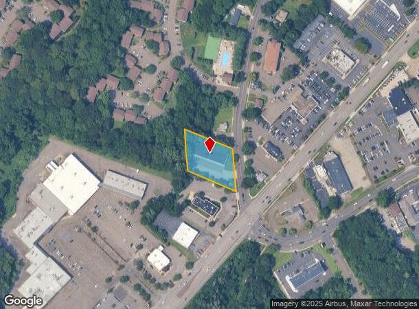
Property Record
137 Baxter Ln, Milford, CT 06460
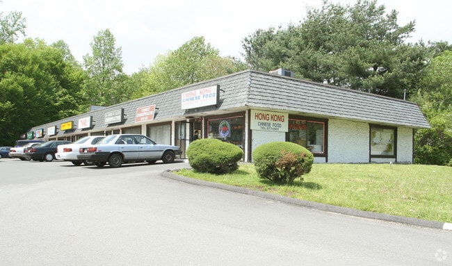
This Property Is For Sale
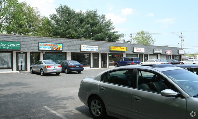
Current Lease Availabilities
NEARBY LISTINGS FOR SALE OR LEASE
Property Detail
137 Baxter Ln
New Haven-Milford, CT
New Haven
MILF-000058-000712-000004E
Connecticut
Sfr
0.23 AC
X
Milford
09009C0532J
Westchester/So Connecticut
1,008 SF
DEMOGRAPHICS near 137 Baxter Ln
1 Mile
3 Mile
5 Mile
2024 Total Population
4,370
50,522
124,563
2029 Population
4,374
50,789
124,783
Pop Growth 2024-2029
+ 0.09%
+ 0.53%
+ 0.18%
Average Age
46
45
43
2024 Total Households
1,829
21,142
50,523
HH Growth 2024-2029
+ 0.05%
+ 0.53%
+ 0.16%
Median Household Inc
$100,301
$103,422
$91,199
Avg Household Size
2.30
2.30
2.30
2024 Avg HH Vehicles
2.00
2.00
2.00
Median Home Value
$348,979
$358,727
$323,337
Median Year Built
1973
1965
1966
Nearby Places
- Restaurants
- Banks
- Shops
- Fitness
- Groceries
PUBLIC TRANSPORTATION
COMMUTER RAIL
Milford Station (New Haven Line - Metro-North Commuter Railroad Company (Metro-North))
DRIVE
WALK
Distance
Milford Station (New Haven Line - Metro-North Commuter Railroad Company (Metro-North))
5 min
2.4 mi
DRIVE
WALK
Distance
8 min
5.0 mi
AIRPORT
Tweed/New Haven
DRIVE
WALK
Distance
Tweed/New Haven
22 min
12.1 mi
Long Island MacArthur
DRIVE
WALK
Distance
Long Island MacArthur
124 min
45.0 mi
Nearby Properties
Address
Land Use
TOTAL SIZE
Lot Size
Zoning
Address
Land Use
TOTAL SIZE
Lot Size
Zoning
74.86 AC
SCD
Address
Land Use
TOTAL SIZE
Lot Size
Zoning
9.05 AC
MCDD
Address
Land Use
TOTAL SIZE
Lot Size
Zoning
35.05 AC
LI-2
Address
Land Use
TOTAL SIZE
Lot Size
Zoning
1,628 SF
22.65 AC
OSAH
Address
Land Use
TOTAL SIZE
Lot Size
Zoning
34.40 AC
SCD
Address
Land Use
TOTAL SIZE
Lot Size
Zoning
214,516 SF
35.88 AC
RA
Address
Land Use
TOTAL SIZE
Lot Size
Zoning
287.63 AC
OS
Address
Land Use
TOTAL SIZE
Lot Size
Zoning
125,676 SF
22.12 AC
BOP
Address
Land Use
TOTAL SIZE
Lot Size
Zoning
1,110 SF
6.76 AC
CDD1
Address
Land Use
TOTAL SIZE
Lot Size
Zoning
3,864 SF
26.06 AC
DO25
Address
Land Use
TOTAL SIZE
Lot Size
Zoning
6.86 AC
RA
Address
Land Use
TOTAL SIZE
Lot Size
Zoning
26,736 SF
10.86 AC
CDD1
Address
Land Use
TOTAL SIZE
Lot Size
Zoning
9 AC
LI-4
Address
Land Use
TOTAL SIZE
Lot Size
Zoning
162,464 SF
7.51 AC
SLD
Address
Land Use
TOTAL SIZE
Lot Size
Zoning
145,145 SF
22.60 AC
MCDD
Address
Land Use
TOTAL SIZE
Lot Size
Zoning
181,277 SF
4.58 AC
CDD5
Address
Land Use
TOTAL SIZE
Lot Size
Zoning
8,060 SF
27.12 AC
RPD
Address
Land Use
TOTAL SIZE
Lot Size
Zoning
20.33 AC
LI-3
Address
Land Use
TOTAL SIZE
Lot Size
Zoning
14.69 AC
WDD
Address
Land Use
TOTAL SIZE
Lot Size
Zoning
6.01 AC
LI-2
Address
Land Use
TOTAL SIZE
Lot Size
Zoning
2.91 AC
MCDD
Address
Land Use
TOTAL SIZE
Lot Size
Zoning
55,894 SF
8.25 AC
LI-2
Address
Land Use
TOTAL SIZE
Lot Size
Zoning
18.14 AC
ID
Address
Land Use
TOTAL SIZE
Lot Size
Zoning
15.51 AC
C-2
Address
Land Use
TOTAL SIZE
Lot Size
Zoning
138,970 SF
14.34 AC
CDD5
Address
Land Use
TOTAL SIZE
Lot Size
Zoning
14,183 SF
16.40 AC
R18
Address
Land Use
TOTAL SIZE
Lot Size
Zoning
47,225 SF
41.33 AC
LI-2
Address
Land Use
TOTAL SIZE
Lot Size
Zoning
97,527 SF
3.70 AC
LI-2
Address
Land Use
TOTAL SIZE
Lot Size
Zoning
21.50 AC
LI
Address
Land Use
TOTAL SIZE
Lot Size
Zoning
127,654 SF
16.55 AC
PF
The World's #1 Commercial Real Estate Marketplace
Connect with us
© 2025 CoStar Group
The information above has been obtained from sources believed reliable. While we do not doubt its accuracy we have not verified it and make no guarantee, warranty or representation about it. It is your responsibility to independently confirm its accuracy and completeness. Any projections, opinions, assumptions, or estimates used are for example only and do not represent the current or future performance of the property. The value of this transaction to you depends on tax and other factors which should be evaluated by your tax, financial, and legal advisors. You and your advisors should conduct a careful, independent investigation of the property to determine to your satisfaction the suitability of the property for your needs.