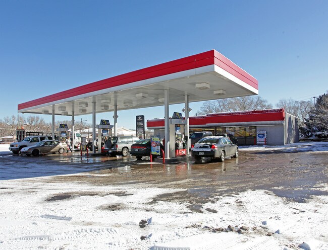
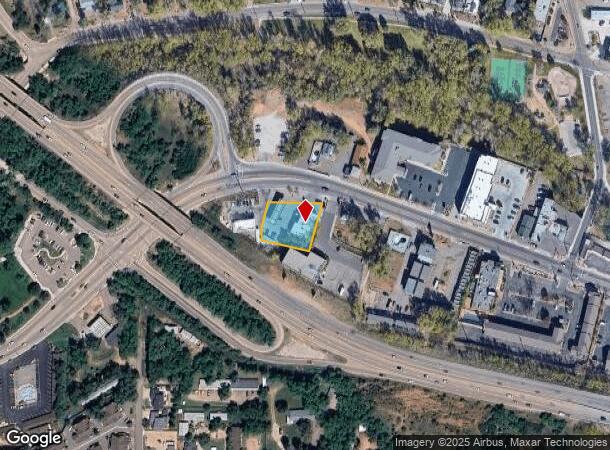
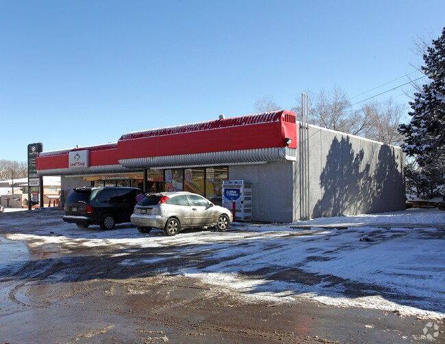
Property Record
137 Manitou Ave, Manitou Springs, CO 80829
NEARBY LISTINGS FOR SALE OR LEASE
Property Detail
137 Manitou Ave
74044-11-032
Monument Add
Commercialbuilding
TRACT IN SW4NW4SE4 SEC 4-14-67 AS FOLS, BEG ON SLY LN OF MANITOU AVE 2177.9 FT NWLY THEREON FROM ITS POI WITH E LN OF SD SEC, TH ANG L SWLY TO INTSEC A LN THAT IS 90.0 FT NLY FROM N R/W LN OF STATE HWY, ANG R NWLY TO INTSEC A LN THAT IS N 00<1900 E 3
A
El Paso
08041C0707G
Colorado
2024
0.67 AC
2025
Northwest
006702
Colorado Springs
3,612 SF
Colorado Springs, CO
DEMOGRAPHICS near 137 Manitou Ave
1 Mile
3 Mile
5 Mile
2024 Total Population
3,989
28,765
88,931
2029 Population
4,167
30,117
92,957
Pop Growth 2024-2029
+ 4.46%
+ 4.70%
+ 4.53%
Average Age
48
46
43
2024 Total Households
1,920
13,796
41,134
HH Growth 2024-2029
+ 4.69%
+ 5.02%
+ 4.80%
Median Household Inc
$83,528
$72,187
$67,953
Avg Household Size
2.00
2.00
2.00
2024 Avg HH Vehicles
2.00
2.00
2.00
Median Home Value
$549,645
$464,469
$451,839
Median Year Built
1970
1975
1971
Nearby Places
Map Layers
Map Styles
 Street
 Aerial
- Restaurants
- Banks
- Shops
- Fitness
- Groceries
PUBLIC TRANSPORTATION
AIRPORT
City of Colorado Springs Municipal
DRIVE
WALK
Distance
City of Colorado Springs Municipal
27 min
15.2 mi
Freight Ports
Tulsa Port Of Catoosa
DRIVE
WALK
Distance
Tulsa Port Of Catoosa
751 min
699.3 mi
Nearby Properties
Address
Land Use
TOTAL SIZE
Lot Size
Zoning
Address
Land Use
TOTAL SIZE
Lot Size
Zoning
107,247 SF
56.98 AC
R-E PF
Address
Land Use
TOTAL SIZE
Lot Size
Zoning
139,621 SF
403.34 AC
A R-E HS
Address
Land Use
TOTAL SIZE
Lot Size
Zoning
2,422 SF
616.19 AC
PK MX-I PD
Address
Land Use
TOTAL SIZE
Lot Size
Zoning
99,488 SF
13.01 AC
PDZ
Address
Land Use
TOTAL SIZE
Lot Size
Zoning
75,349 SF
27.75 AC
EPC
Address
Land Use
TOTAL SIZE
Lot Size
Zoning
45,268 SF
8.37 AC
PDZ UV
Address
Land Use
TOTAL SIZE
Lot Size
Zoning
37,196 SF
3 AC
PDZ
Address
Land Use
TOTAL SIZE
Lot Size
Zoning
99,085 SF
6.85 AC
R-1 6
Address
Land Use
TOTAL SIZE
Lot Size
Zoning
282,722 SF
11.15 AC
PDZ HS SS
Address
Land Use
TOTAL SIZE
Lot Size
Zoning
34,126 SF
1.37 AC
Address
Land Use
TOTAL SIZE
Lot Size
Zoning
129,525 SF
9 AC
PDZ SS
Address
Land Use
TOTAL SIZE
Lot Size
Zoning
212,439 SF
12.67 AC
R-5 UV
Address
Land Use
TOTAL SIZE
Lot Size
Zoning
267,790 SF
15.13 AC
PDZ HS
Address
Land Use
TOTAL SIZE
Lot Size
Zoning
115,608 SF
9.45 AC
MX-M
Address
Land Use
TOTAL SIZE
Lot Size
Zoning
157,471 SF
0.02 AC
PUD,HS
Address
Land Use
TOTAL SIZE
Lot Size
Zoning
17,764 SF
1.63 AC
PDZ
Address
Land Use
TOTAL SIZE
Lot Size
Zoning
255,307 SF
18.58 AC
R-5
Address
Land Use
TOTAL SIZE
Lot Size
Zoning
20,147 SF
38.98 AC
PK HS
Address
Land Use
TOTAL SIZE
Lot Size
Zoning
127.25 AC
PK HS
Address
Land Use
TOTAL SIZE
Lot Size
Zoning
31,314 SF
1.55 AC
MX-M/CR
Address
Land Use
TOTAL SIZE
Lot Size
Zoning
34,296 SF
0.85 AC
Address
Land Use
TOTAL SIZE
Lot Size
Zoning
3,058 SF
28.22 AC
HLDR
Address
Land Use
TOTAL SIZE
Lot Size
Zoning
6,658 SF
189.56 AC
R-E PK HS
Address
Land Use
TOTAL SIZE
Lot Size
Zoning
66,223 SF
3.67 AC
MX-N
Address
Land Use
TOTAL SIZE
Lot Size
Zoning
14,263 SF
0.98 AC
R-2 R-5
Address
Land Use
TOTAL SIZE
Lot Size
Zoning
80 AC
PK HS SS
Address
Land Use
TOTAL SIZE
Lot Size
Zoning
1,188 SF
27.20 AC
R-E
Address
Land Use
TOTAL SIZE
Lot Size
Zoning
464,447 SF
17.53 AC
PDZ
Address
Land Use
TOTAL SIZE
Lot Size
Zoning
33,548 SF
3.80 AC
R-E
Address
Land Use
TOTAL SIZE
Lot Size
Zoning
31,110 SF
9.38 AC
R-1 6
The World's #1 Commercial Real Estate Marketplace
Connect with us
© 2025 CoStar Group
The information above has been obtained from sources believed reliable. While we do not doubt its accuracy we have not verified it and make no guarantee, warranty or representation about it. It is your responsibility to independently confirm its accuracy and completeness. Any projections, opinions, assumptions, or estimates used are for example only and do not represent the current or future performance of the property. The value of this transaction to you depends on tax and other factors which should be evaluated by your tax, financial, and legal advisors. You and your advisors should conduct a careful, independent investigation of the property to determine to your satisfaction the suitability of the property for your needs.