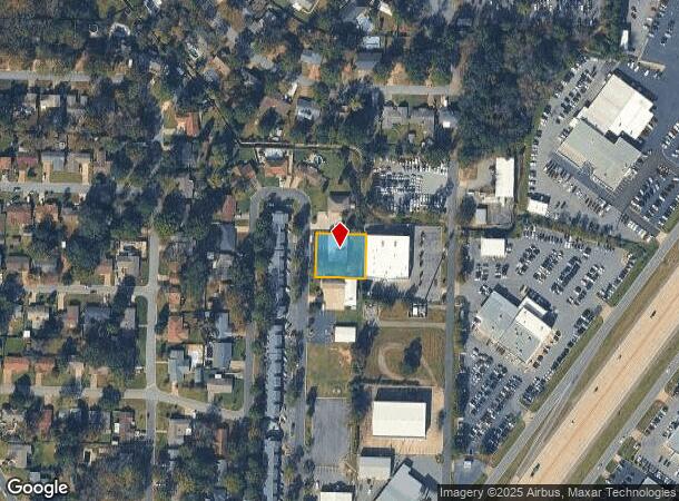
Property Record
137 Shadow Oaks Dr, Sherwood, AR 72120
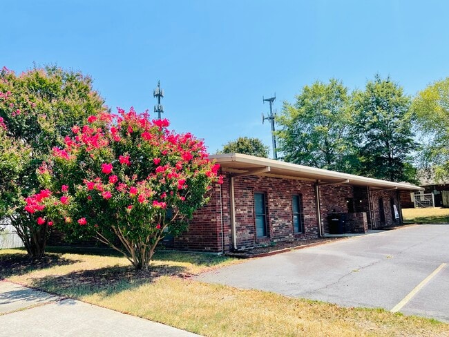

This Property Is For Sale
Current Lease Availabilities
NEARBY LISTINGS FOR SALE OR LEASE
Property Detail
137 Shadow Oaks Dr
23S-058-00-016-02
Shadow Oaks Addn
Officebuilding
Pulaski
X
Arkansas
05119C0362G
12
2025
0.40 AC
2025
Outlying Pulaski County
003703
Little Rock/N Little Rock
3,606 SF
Little Rock-North Little Rock-Conway, AR
DEMOGRAPHICS near 137 Shadow Oaks Dr
1 Mile
3 Mile
5 Mile
2024 Total Population
4,618
48,054
91,051
2029 Population
4,551
47,777
91,356
Pop Growth 2024-2029
(1.45%)
(0.58%)
+ 0.33%
Average Age
43
41
40
2024 Total Households
1,957
20,930
39,388
HH Growth 2024-2029
(1.48%)
(0.50%)
+ 0.38%
Median Household Inc
$82,349
$63,342
$49,886
Avg Household Size
2.30
2.20
2.20
2024 Avg HH Vehicles
2.00
2.00
2.00
Median Home Value
$176,927
$180,666
$162,674
Median Year Built
1975
1979
1976
Nearby Places
- Restaurants
- Banks
- Shops
- Fitness
- Groceries
PUBLIC TRANSPORTATION
COMMUTER RAIL
Little Rock Union Station (Texas Eagle - Amtrak)
DRIVE
WALK
Distance
Little Rock Union Station (Texas Eagle - Amtrak)
12 min
7.4 mi
AIRPORT
Bill and Hillary Clinton Ntl/Adams Field
DRIVE
WALK
Distance
Bill and Hillary Clinton Ntl/Adams Field
17 min
11.0 mi
Freight Ports
Port of Shreveport
DRIVE
WALK
Distance
Port of Shreveport
259 min
239.9 mi
Nearby Properties
Address
Land Use
TOTAL SIZE
Lot Size
Zoning
Address
Land Use
TOTAL SIZE
Lot Size
Zoning
526,829 SF
33.78 AC
Address
Land Use
TOTAL SIZE
Lot Size
Zoning
379,202 SF
118.65 AC
Address
Land Use
TOTAL SIZE
Lot Size
Zoning
82,978 SF
12.54 AC
Address
Land Use
TOTAL SIZE
Lot Size
Zoning
72,806 SF
10.95 AC
Address
Land Use
TOTAL SIZE
Lot Size
Zoning
36,711 SF
28.35 AC
Address
Land Use
TOTAL SIZE
Lot Size
Zoning
195,404 SF
25.19 AC
Address
Land Use
TOTAL SIZE
Lot Size
Zoning
2,414 SF
25.25 AC
Address
Land Use
TOTAL SIZE
Lot Size
Zoning
17,352 SF
42.55 AC
Address
Land Use
TOTAL SIZE
Lot Size
Zoning
157,477 SF
9.35 AC
Address
Land Use
TOTAL SIZE
Lot Size
Zoning
4,112 SF
15.95 AC
Address
Land Use
TOTAL SIZE
Lot Size
Zoning
453,687 SF
Address
Land Use
TOTAL SIZE
Lot Size
Zoning
90,220 SF
18.65 AC
Address
Land Use
TOTAL SIZE
Lot Size
Zoning
141,362 SF
14.25 AC
Address
Land Use
TOTAL SIZE
Lot Size
Zoning
73,763 SF
23.09 AC
Address
Land Use
TOTAL SIZE
Lot Size
Zoning
38,202 SF
14.23 AC
Address
Land Use
TOTAL SIZE
Lot Size
Zoning
33,000 SF
15.96 AC
Address
Land Use
TOTAL SIZE
Lot Size
Zoning
36,934 SF
15.06 AC
Address
Land Use
TOTAL SIZE
Lot Size
Zoning
75,462 SF
5.33 AC
Address
Land Use
TOTAL SIZE
Lot Size
Zoning
6,460 SF
24.35 AC
Address
Land Use
TOTAL SIZE
Lot Size
Zoning
219,330 SF
24.14 AC
Address
Land Use
TOTAL SIZE
Lot Size
Zoning
83,431 SF
10.99 AC
Address
Land Use
TOTAL SIZE
Lot Size
Zoning
46,451 SF
12.94 AC
Address
Land Use
TOTAL SIZE
Lot Size
Zoning
49,995 SF
12.92 AC
Address
Land Use
TOTAL SIZE
Lot Size
Zoning
191,252 SF
16.94 AC
Address
Land Use
TOTAL SIZE
Lot Size
Zoning
102,858 SF
10.19 AC
Address
Land Use
TOTAL SIZE
Lot Size
Zoning
85,948 SF
3.29 AC
Address
Land Use
TOTAL SIZE
Lot Size
Zoning
154,854 SF
5.40 AC
Address
Land Use
TOTAL SIZE
Lot Size
Zoning
72,157 SF
9.45 AC
Address
Land Use
TOTAL SIZE
Lot Size
Zoning
31,644 SF
Address
Land Use
TOTAL SIZE
Lot Size
Zoning
51,758 SF
17.08 AC
The World's #1 Commercial Real Estate Marketplace
Connect with us
© 2025 CoStar Group
The information above has been obtained from sources believed reliable. While we do not doubt its accuracy we have not verified it and make no guarantee, warranty or representation about it. It is your responsibility to independently confirm its accuracy and completeness. Any projections, opinions, assumptions, or estimates used are for example only and do not represent the current or future performance of the property. The value of this transaction to you depends on tax and other factors which should be evaluated by your tax, financial, and legal advisors. You and your advisors should conduct a careful, independent investigation of the property to determine to your satisfaction the suitability of the property for your needs.