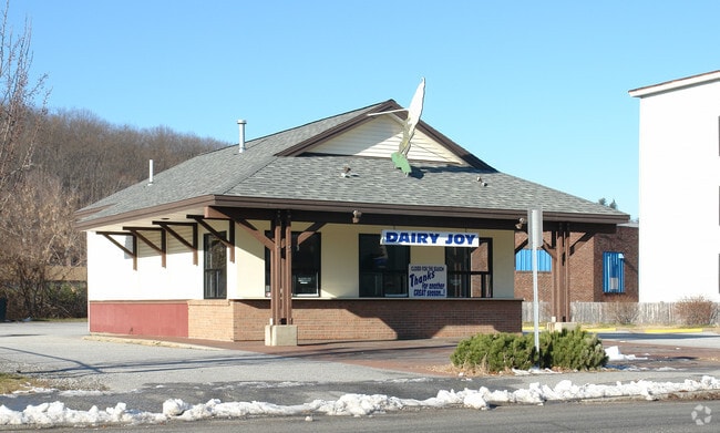
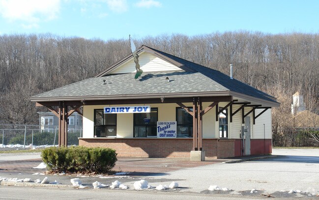
Property Record
137 Spring St, Auburn, ME 04210

Property Detail
137 Spring St
AUBN-000230-000000-000069-000001
Androscoggin
Restaurantbuilding
Maine
B and X Area of moderate flood hazard, usually the area between the limits of the 100-year and 500-year floods.
69-1
2025
0.28 AC
2025
Other Market Areas
010100
Lewiston-Auburn, ME
864 SF
NEARBY LISTINGS FOR SALE OR LEASE
DEMOGRAPHICS near 137 Spring St
1 mile
3 mile
5 mile
2025 Total Population
16,787
50,046
62,712
2030 Population
17,276
51,276
64,177
Pop Growth 2025-2030
+ 2.91%
+ 2.46%
+ 2.34%
Average Age
38
40
40
2025 Total Households
7,007
20,205
25,426
HH Growth 2025-2030
+ 2.95%
+ 2.39%
+ 2.35%
Median Household Inc
$40,605
$51,225
$56,256
Avg Household Size
2.20
2.20
2.20
2025 Avg HH Vehicles
1.00
1.00
2.00
Median Home Value
$250,836
$252,696
$258,035
Median Year Built
1947
1949
1955
Nearby Places
Map Layers
Map Styles
 Street
 Aerial
Layers
 Traffic
 Biking
Places
Listings with unknown addresses are not visible on the map
- Restaurants
- Banks
- Shops
- Fitness
- Groceries
PUBLIC TRANSPORTATION
AIRPORT
Portland International Jetport
Drive
Walk
Distance
Portland International Jetport
46 min
35.6 mi
Freight Ports
Portland, ME
Drive
Walk
Distance
Portland, ME
46 min
35.2 mi
Nearby Properties
Address
Land Use
TOTAL SIZE
Lot Size
Zoning
Address
Land Use
TOTAL SIZE
Lot Size
Zoning
542,760 SF
8.12 AC
Address
Land Use
TOTAL SIZE
Lot Size
Zoning
290,822 SF
61.58 AC
Address
Land Use
TOTAL SIZE
Lot Size
Zoning
295,277 SF
124.77 AC
Address
Land Use
TOTAL SIZE
Lot Size
Zoning
Address
Land Use
TOTAL SIZE
Lot Size
Zoning
7.76 AC
Address
Land Use
TOTAL SIZE
Lot Size
Zoning
34,797 SF
10.98 AC
Address
Land Use
TOTAL SIZE
Lot Size
Zoning
50,000 SF
86.08 AC
Address
Land Use
TOTAL SIZE
Lot Size
Zoning
1.53 AC
Address
Land Use
TOTAL SIZE
Lot Size
Zoning
49,842 SF
23 AC
Address
Land Use
TOTAL SIZE
Lot Size
Zoning
144,650 SF
16.19 AC
Address
Land Use
TOTAL SIZE
Lot Size
Zoning
67,873 SF
Address
Land Use
TOTAL SIZE
Lot Size
Zoning
290,142 SF
33.80 AC
Address
Land Use
TOTAL SIZE
Lot Size
Zoning
220,227 SF
35.93 AC
Address
Land Use
TOTAL SIZE
Lot Size
Zoning
260,479 SF
23.56 AC
Address
Land Use
TOTAL SIZE
Lot Size
Zoning
106,600 SF
0.73 AC
Address
Land Use
TOTAL SIZE
Lot Size
Zoning
511,690 SF
139.18 AC
Address
Land Use
TOTAL SIZE
Lot Size
Zoning
93,343 SF
16.41 AC
Address
Land Use
TOTAL SIZE
Lot Size
Zoning
127,660 SF
9.24 AC
Address
Land Use
TOTAL SIZE
Lot Size
Zoning
27,606 SF
1.10 AC
Address
Land Use
TOTAL SIZE
Lot Size
Zoning
77,416 SF
2.88 AC
Address
Land Use
TOTAL SIZE
Lot Size
Zoning
90,085 SF
1.49 AC
Address
Land Use
TOTAL SIZE
Lot Size
Zoning
144,665 SF
36.25 AC
Address
Land Use
TOTAL SIZE
Lot Size
Zoning
3,027 SF
13.19 AC
Address
Land Use
TOTAL SIZE
Lot Size
Zoning
210,388 SF
1.46 AC
Address
Land Use
TOTAL SIZE
Lot Size
Zoning
134,613 SF
26.87 AC
Address
Land Use
TOTAL SIZE
Lot Size
Zoning
125,449 SF
Address
Land Use
TOTAL SIZE
Lot Size
Zoning
94,914 SF
Address
Land Use
TOTAL SIZE
Lot Size
Zoning
76,915 SF
1.83 AC
Address
Land Use
TOTAL SIZE
Lot Size
Zoning
155,140 SF
26.55 AC
Address
Land Use
TOTAL SIZE
Lot Size
Zoning
60,728 SF
0.86 AC
The World's #1 Commercial Real Estate Marketplace
Connect with us
© 2026 CoStar Group
The information above has been obtained from sources believed reliable. While we do not doubt its accuracy we have not verified it and make no guarantee, warranty or representation about it. It is your responsibility to independently confirm its accuracy and completeness. Any projections, opinions, assumptions, or estimates used are for example only and do not represent the current or future performance of the property. The value of this transaction to you depends on tax and other factors which should be evaluated by your tax, financial, and legal advisors. You and your advisors should conduct a careful, independent investigation of the property to determine to your satisfaction the suitability of the property for your needs.