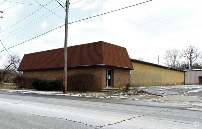
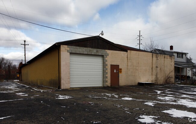
Property Record
137 W 6Th St, Mansfield, OH 44902
NEARBY LISTINGS FOR SALE OR LEASE
Property Detail
137 W 6Th St
027-04-016-04-000
1079 & 10 FT VAC ALLEY TO W 70 X 180
Warehouse
Richland
AE
Ohio
39139C0144E
0.29 AC
2024
Richland County
2024
Cleveland
000600
Mansfield, OH
9,240 SF
DEMOGRAPHICS near 137 W 6Th St
1 Mile
3 Mile
5 Mile
2024 Total Population
10,568
51,399
74,425
2029 Population
10,824
51,868
74,897
Pop Growth 2024-2029
+ 2.42%
+ 0.91%
+ 0.63%
Average Age
37
40
41
2024 Total Households
4,388
20,344
30,358
HH Growth 2024-2029
+ 2.46%
+ 0.93%
+ 0.64%
Median Household Inc
$21,837
$35,840
$42,634
Avg Household Size
2.20
2.20
2.20
2024 Avg HH Vehicles
1.00
1.00
2.00
Median Home Value
$59,864
$82,866
$119,444
Median Year Built
1948
1956
1961
Nearby Places
- Restaurants
- Banks
- Shops
- Fitness
- Groceries
SALE & LEASE HISTORY
LISTING DATE
SALE/LEASE

Sep 23, 2016
For Sale
Mar 13, 2018
For Lease
Nearby Properties
Address
Land Use
TOTAL SIZE
Lot Size
Zoning
Address
Land Use
TOTAL SIZE
Lot Size
Zoning
456.50 AC
Address
Land Use
TOTAL SIZE
Lot Size
Zoning
492,672 SF
6.83 AC
Address
Land Use
TOTAL SIZE
Lot Size
Zoning
354,710 SF
7.07 AC
Address
Land Use
TOTAL SIZE
Lot Size
Zoning
139,809 SF
0.99 AC
Address
Land Use
TOTAL SIZE
Lot Size
Zoning
0.06 AC
Address
Land Use
TOTAL SIZE
Lot Size
Zoning
148,135 SF
6.89 AC
Address
Land Use
TOTAL SIZE
Lot Size
Zoning
2.31 AC
Address
Land Use
TOTAL SIZE
Lot Size
Zoning
221,864 SF
20 AC
Address
Land Use
TOTAL SIZE
Lot Size
Zoning
318,366 SF
26.16 AC
Address
Land Use
TOTAL SIZE
Lot Size
Zoning
458,316 SF
27.90 AC
Address
Land Use
TOTAL SIZE
Lot Size
Zoning
92,587 SF
48.78 AC
Address
Land Use
TOTAL SIZE
Lot Size
Zoning
52.67 AC
Address
Land Use
TOTAL SIZE
Lot Size
Zoning
32,728 SF
56.23 AC
Address
Land Use
TOTAL SIZE
Lot Size
Zoning
48,602 SF
14.66 AC
Address
Land Use
TOTAL SIZE
Lot Size
Zoning
66,940 SF
12.40 AC
Address
Land Use
TOTAL SIZE
Lot Size
Zoning
1.69 AC
Address
Land Use
TOTAL SIZE
Lot Size
Zoning
47.90 AC
Address
Land Use
TOTAL SIZE
Lot Size
Zoning
44,718 SF
0.47 AC
Address
Land Use
TOTAL SIZE
Lot Size
Zoning
30,306 SF
5.63 AC
Address
Land Use
TOTAL SIZE
Lot Size
Zoning
63,442 SF
5.51 AC
Address
Land Use
TOTAL SIZE
Lot Size
Zoning
161,297 SF
8.12 AC
Address
Land Use
TOTAL SIZE
Lot Size
Zoning
106,361 SF
5.06 AC
Address
Land Use
TOTAL SIZE
Lot Size
Zoning
88,556 SF
12.32 AC
Address
Land Use
TOTAL SIZE
Lot Size
Zoning
2,948 SF
10.62 AC
Address
Land Use
TOTAL SIZE
Lot Size
Zoning
21,337 SF
11.30 AC
Address
Land Use
TOTAL SIZE
Lot Size
Zoning
82,695 SF
40.16 AC
Address
Land Use
TOTAL SIZE
Lot Size
Zoning
80,956 SF
17.24 AC
Address
Land Use
TOTAL SIZE
Lot Size
Zoning
75,157 SF
0.41 AC
Address
Land Use
TOTAL SIZE
Lot Size
Zoning
31,064 SF
9 AC
Address
Land Use
TOTAL SIZE
Lot Size
Zoning
25,061 SF
4.30 AC
The World's #1 Commercial Real Estate Marketplace
Connect with us
© 2025 CoStar Group
The information above has been obtained from sources believed reliable. While we do not doubt its accuracy we have not verified it and make no guarantee, warranty or representation about it. It is your responsibility to independently confirm its accuracy and completeness. Any projections, opinions, assumptions, or estimates used are for example only and do not represent the current or future performance of the property. The value of this transaction to you depends on tax and other factors which should be evaluated by your tax, financial, and legal advisors. You and your advisors should conduct a careful, independent investigation of the property to determine to your satisfaction the suitability of the property for your needs.