Property Record
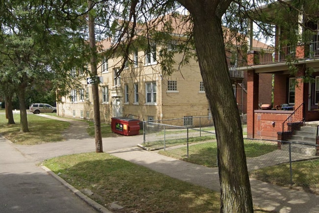
13700 La Salle Blvd, Detroit, MI 48238


This Property Is For Sale
NEARBY LISTINGS FOR SALE OR LEASE
Property Detail
13700 La Salle Blvd
08-010223
Robert Oakmans Twelfth St
Multifamilydwelling
E LASALLE 933 S 5.50 FT 934 R OAKMANS 12TH ST SUB L34 P90 PLATS, W C R 8/145 47 X 110
X
Wayne
26163C0125E
Michigan
2025
0.12 AC
2025
North Detroit
531700
Detroit
6,996 SF
Detroit-Warren-Dearborn, MI
DEMOGRAPHICS near 13700 La Salle Blvd
1 Mile
3 Mile
5 Mile
2024 Total Population
18,714
155,392
428,572
2029 Population
19,260
157,496
426,096
Pop Growth 2024-2029
+ 2.92%
+ 1.35%
(0.58%)
Average Age
39
39
38
2024 Total Households
8,292
64,125
168,738
HH Growth 2024-2029
+ 2.87%
+ 1.49%
(0.35%)
Median Household Inc
$23,239
$33,483
$36,687
Avg Household Size
2.20
2.30
2.40
2024 Avg HH Vehicles
1.00
1.00
1.00
Median Home Value
$84,860
$88,031
$90,197
Median Year Built
1946
1947
1948
Nearby Places
Map Layers
Map Styles
 Street
 Aerial
- Restaurants
- Banks
- Shops
- Fitness
- Groceries
PUBLIC TRANSPORTATION
COMMUTER RAIL
Detroit (Wolverine - Amtrak)
DRIVE
WALK
Distance
Detroit (Wolverine - Amtrak)
8 min
3.9 mi
AIRPORT
Windsor International
DRIVE
WALK
Distance
Windsor International
33 min
16.3 mi
Detroit Metro Wayne County
DRIVE
WALK
Distance
Detroit Metro Wayne County
36 min
24.7 mi
Freight Ports
Port of Toledo
DRIVE
WALK
Distance
Port of Toledo
82 min
65.5 mi
Nearby Properties
Address
Land Use
TOTAL SIZE
Lot Size
Zoning
Address
Land Use
TOTAL SIZE
Lot Size
Zoning
334,904 SF
B5
Address
Land Use
TOTAL SIZE
Lot Size
Zoning
506,450 SF
3.84 AC
B5
Address
Land Use
TOTAL SIZE
Lot Size
Zoning
266,016 SF
7.76 AC
PD
Address
Land Use
TOTAL SIZE
Lot Size
Zoning
531,360 SF
1.44 AC
B5
Address
Land Use
TOTAL SIZE
Lot Size
Zoning
678,539 SF
3.52 AC
B5
Address
Land Use
TOTAL SIZE
Lot Size
Zoning
164,797 SF
2.03 AC
Address
Land Use
TOTAL SIZE
Lot Size
Zoning
449,083 SF
2.39 AC
B2
Address
Land Use
TOTAL SIZE
Lot Size
Zoning
171,665 SF
3.73 AC
R5
Address
Land Use
TOTAL SIZE
Lot Size
Zoning
76,986 SF
2.73 AC
B4
Address
Land Use
TOTAL SIZE
Lot Size
Zoning
331,559 SF
11.42 AC
M4
Address
Land Use
TOTAL SIZE
Lot Size
Zoning
564,958 SF
9.69 AC
M4
Address
Land Use
TOTAL SIZE
Lot Size
Zoning
135,296 SF
1.09 AC
R5
Address
Land Use
TOTAL SIZE
Lot Size
Zoning
263,240 SF
1.21 AC
B4
Address
Land Use
TOTAL SIZE
Lot Size
Zoning
185,944 SF
B2
Address
Land Use
TOTAL SIZE
Lot Size
Zoning
446,500 SF
27.90 AC
Address
Land Use
TOTAL SIZE
Lot Size
Zoning
224,410 SF
2.11 AC
M3
Address
Land Use
TOTAL SIZE
Lot Size
Zoning
214,306 SF
3.76 AC
R3
Address
Land Use
TOTAL SIZE
Lot Size
Zoning
Address
Land Use
TOTAL SIZE
Lot Size
Zoning
165,829 SF
5.56 AC
R5
Address
Land Use
TOTAL SIZE
Lot Size
Zoning
292,032 SF
20.25 AC
B4
Address
Land Use
TOTAL SIZE
Lot Size
Zoning
46,723 SF
B2
Address
Land Use
TOTAL SIZE
Lot Size
Zoning
58,261 SF
607 AC
B5
Address
Land Use
TOTAL SIZE
Lot Size
Zoning
353,800 SF
15.70 AC
Address
Land Use
TOTAL SIZE
Lot Size
Zoning
75,870 SF
B5
Address
Land Use
TOTAL SIZE
Lot Size
Zoning
301,000 SF
Address
Land Use
TOTAL SIZE
Lot Size
Zoning
150,689 SF
4.87 AC
R5
Address
Land Use
TOTAL SIZE
Lot Size
Zoning
500,072 SF
12.50 AC
SD2
Address
Land Use
TOTAL SIZE
Lot Size
Zoning
63,216 SF
2.87 AC
R5
Address
Land Use
TOTAL SIZE
Lot Size
Zoning
66,870 SF
2.77 AC
Address
Land Use
TOTAL SIZE
Lot Size
Zoning
104,625 SF
1.80 AC
B4
The World's #1 Commercial Real Estate Marketplace
Connect with us
© 2026 CoStar Group
The information above has been obtained from sources believed reliable. While we do not doubt its accuracy we have not verified it and make no guarantee, warranty or representation about it. It is your responsibility to independently confirm its accuracy and completeness. Any projections, opinions, assumptions, or estimates used are for example only and do not represent the current or future performance of the property. The value of this transaction to you depends on tax and other factors which should be evaluated by your tax, financial, and legal advisors. You and your advisors should conduct a careful, independent investigation of the property to determine to your satisfaction the suitability of the property for your needs.