Property Record
1371 N Lecanto Hwy, Lecanto, FL 34461
NEARBY LISTINGS FOR SALE OR LEASE
Property Detail
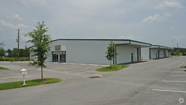
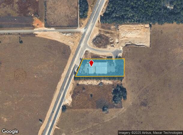
1371 N Lecanto Hwy
Homosassa Springs, FL
Unrec Tracts In 28-18S-18E
18E-18S-28-0000-20000-0030
(MSP-02-03 ACCEPTED 3/20/02 SURVEY IN OR BK 1493 PG 408) TRACT 3: COM AT THE SE COR OF SEC 28-18-18 SD COR ALSO BEING THE SW COR OF SEC 27-18-18 & ALSO BEING THE SW COR OF TIMBERLANE ESTS REVISED PB 11 PG 32 TH N 0D 46M 01S E AL THE E LN OF SD SEC 28
Warehouse
Citrus
X
Florida
12017C0213D
272
2024
2.35 AC
2025
Florida Central North Area
450704
Other Market Areas
20,875 SF
DEMOGRAPHICS near 1371 N Lecanto Hwy
1 Mile
3 Mile
5 Mile
2024 Total Population
637
18,827
44,236
2029 Population
716
21,271
49,979
Pop Growth 2024-2029
+ 12.40%
+ 12.98%
+ 12.98%
Average Age
53
55
53
2024 Total Households
268
8,449
19,777
HH Growth 2024-2029
+ 11.94%
+ 12.75%
+ 12.72%
Median Household Inc
$44,749
$50,041
$52,356
Avg Household Size
2.20
2.10
2.10
2024 Avg HH Vehicles
2.00
2.00
2.00
Median Home Value
$249,047
$252,703
$239,111
Median Year Built
1992
1993
1991
Nearby Places
Map Layers
Map Styles
 Street
 Aerial
- Restaurants
- Banks
- Shops
- Fitness
- Groceries
SALE & LEASE HISTORY
LISTING DATE
SALE/LEASE

Sep 25, 2016
For Lease
May 22, 2018
For Lease
Nearby Properties
Address
Land Use
TOTAL SIZE
Lot Size
Zoning
Address
Land Use
TOTAL SIZE
Lot Size
Zoning
840,664 SF
6.64 AC
PDR
Address
Land Use
TOTAL SIZE
Lot Size
Zoning
198,657 SF
73.75 AC
PSI
Address
Land Use
TOTAL SIZE
Lot Size
Zoning
405,045 SF
18.52 AC
PSI
Address
Land Use
TOTAL SIZE
Lot Size
Zoning
135,334 SF
11.45 AC
GNC
Address
Land Use
TOTAL SIZE
Lot Size
Zoning
901,824 SF
14.37 AC
GNC
Address
Land Use
TOTAL SIZE
Lot Size
Zoning
92,500 SF
5.11 AC
PSO
Address
Land Use
TOTAL SIZE
Lot Size
Zoning
66,513 SF
31.85 AC
PSI
Address
Land Use
TOTAL SIZE
Lot Size
Zoning
664,950 SF
20.21 AC
IND
Address
Land Use
TOTAL SIZE
Lot Size
Zoning
42,396 SF
20.02 AC
PSI
Address
Land Use
TOTAL SIZE
Lot Size
Zoning
300,060 SF
8.74 AC
PDR
Address
Land Use
TOTAL SIZE
Lot Size
Zoning
178,134 SF
10.77 AC
PDR
Address
Land Use
TOTAL SIZE
Lot Size
Zoning
98,862 SF
18.36 AC
RUR
Address
Land Use
TOTAL SIZE
Lot Size
Zoning
57,652 SF
11.85 AC
GNC
Address
Land Use
TOTAL SIZE
Lot Size
Zoning
447,538 SF
7.06 AC
PDR
Address
Land Use
TOTAL SIZE
Lot Size
Zoning
345,488 SF
5.87 AC
PDR
Address
Land Use
TOTAL SIZE
Lot Size
Zoning
55,949 SF
4.71 AC
GNC
Address
Land Use
TOTAL SIZE
Lot Size
Zoning
22.87 AC
GNC
Address
Land Use
TOTAL SIZE
Lot Size
Zoning
214,450 SF
9.18 AC
GNC
Address
Land Use
TOTAL SIZE
Lot Size
Zoning
42,134 SF
4.52 AC
GNC
Address
Land Use
TOTAL SIZE
Lot Size
Zoning
164,940 SF
10.36 AC
PDR
Address
Land Use
TOTAL SIZE
Lot Size
Zoning
53,425 SF
5.18 AC
PDR
Address
Land Use
TOTAL SIZE
Lot Size
Zoning
13,025 SF
1.93 AC
PDR
Address
Land Use
TOTAL SIZE
Lot Size
Zoning
78,432 SF
18.88 AC
PSI
Address
Land Use
TOTAL SIZE
Lot Size
Zoning
155,752 SF
32.74 AC
PDR
Address
Land Use
TOTAL SIZE
Lot Size
Zoning
54,753 SF
14.95 AC
PSI
Address
Land Use
TOTAL SIZE
Lot Size
Zoning
76,562 SF
212.56 AC
PDR
Address
Land Use
TOTAL SIZE
Lot Size
Zoning
36,430 SF
14.26 AC
GNC
Address
Land Use
TOTAL SIZE
Lot Size
Zoning
5,526 SF
4.72 AC
GNC
Address
Land Use
TOTAL SIZE
Lot Size
Zoning
20,492 SF
2.61 AC
GNC
Address
Land Use
TOTAL SIZE
Lot Size
Zoning
23,540 SF
8.97 AC
PSO
The World's #1 Commercial Real Estate Marketplace
Connect with us
© 2025 CoStar Group
The information above has been obtained from sources believed reliable. While we do not doubt its accuracy we have not verified it and make no guarantee, warranty or representation about it. It is your responsibility to independently confirm its accuracy and completeness. Any projections, opinions, assumptions, or estimates used are for example only and do not represent the current or future performance of the property. The value of this transaction to you depends on tax and other factors which should be evaluated by your tax, financial, and legal advisors. You and your advisors should conduct a careful, independent investigation of the property to determine to your satisfaction the suitability of the property for your needs.