Property Record
Tulip Ln, Bethlehem, PA 18015
NEARBY LISTINGS FOR SALE OR LEASE
Property Detail
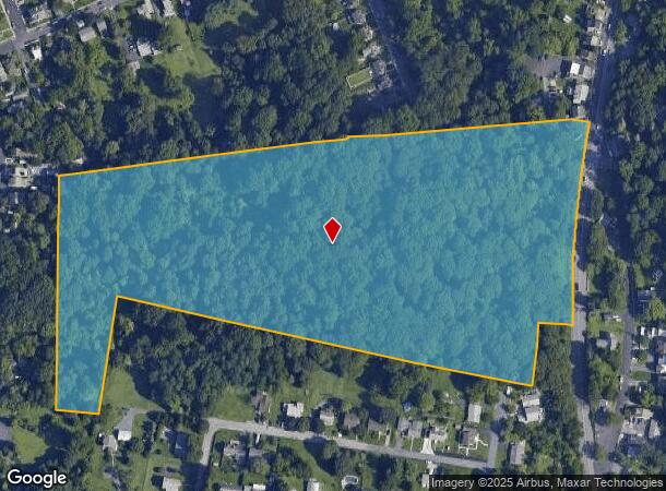
Tulip Ln
Allentown-Bethlehem-Easton, PA-NJ
LOTS: 037
642639109755-1
Lehigh
Residentialacreage
Pennsylvania
X
37
42095C0307E
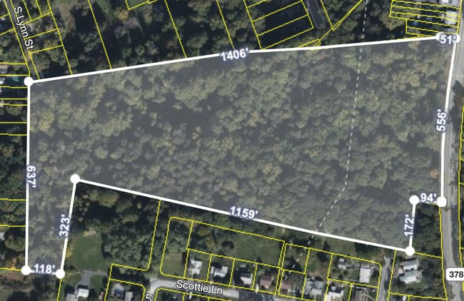
17.78 AC
2025
Lehigh Valley
2025
Philadelphia
018004
DEMOGRAPHICS near Tulip Ln
1 Mile
3 Mile
5 Mile
2024 Total Population
14,360
84,529
226,404
2029 Population
14,371
84,989
227,827
Pop Growth 2024-2029
+ 0.08%
+ 0.54%
+ 0.63%
Average Age
35
39
38
2024 Total Households
4,325
32,036
85,316
HH Growth 2024-2029
+ 0.58%
+ 0.62%
+ 0.73%
Median Household Inc
$51,156
$56,835
$58,049
Avg Household Size
2.50
2.40
2.50
2024 Avg HH Vehicles
2.00
2.00
2.00
Median Home Value
$176,507
$196,469
$205,705
Median Year Built
1947
1952
1956
Nearby Places
Map Layers
Map Styles
 Street
 Aerial
- Restaurants
- Banks
- Shops
- Fitness
- Groceries
PUBLIC TRANSPORTATION
AIRPORT
Lehigh Valley International
DRIVE
WALK
Distance
Lehigh Valley International
15 min
7.0 mi
Freight Ports
Port of Philadelphia
DRIVE
WALK
Distance
Port of Philadelphia
81 min
50.2 mi
SALE & LEASE HISTORY
LISTING DATE
SALE/LEASE

Jul 18, 2022
For Sale
Nearby Properties
Address
Land Use
TOTAL SIZE
Lot Size
Zoning
Address
Land Use
TOTAL SIZE
Lot Size
Zoning
541,843 SF
35.82 AC
INST
Address
Land Use
TOTAL SIZE
Lot Size
Zoning
425,507 SF
52.58 AC
HI
Address
Land Use
TOTAL SIZE
Lot Size
Zoning
53,602 SF
55.38 AC
E
Address
Land Use
TOTAL SIZE
Lot Size
Zoning
184,739 SF
6.75 AC
I
Address
Land Use
TOTAL SIZE
Lot Size
Zoning
29,982 SF
14.39 AC
RT
Address
Land Use
TOTAL SIZE
Lot Size
Zoning
101,901 SF
29.01 AC
E
Address
Land Use
TOTAL SIZE
Lot Size
Zoning
565,540 SF
65.99 AC
I
Address
Land Use
TOTAL SIZE
Lot Size
Zoning
12,838 SF
36.50 AC
IP
Address
Land Use
TOTAL SIZE
Lot Size
Zoning
19,581 SF
15.99 AC
R-MP
Address
Land Use
TOTAL SIZE
Lot Size
Zoning
139,782 SF
27.47 AC
R4
Address
Land Use
TOTAL SIZE
Lot Size
Zoning
57,441 SF
19.85 AC
CS
Address
Land Use
TOTAL SIZE
Lot Size
Zoning
11,856 SF
454.48 AC
CM
Address
Land Use
TOTAL SIZE
Lot Size
Zoning
332,641 SF
2.27 AC
HI
Address
Land Use
TOTAL SIZE
Lot Size
Zoning
800,250 SF
40.07 AC
HI
Address
Land Use
TOTAL SIZE
Lot Size
Zoning
106,829 SF
14.15 AC
R4
Address
Land Use
TOTAL SIZE
Lot Size
Zoning
80,277 SF
3.23 AC
MHDR
Address
Land Use
TOTAL SIZE
Lot Size
Zoning
10,572 SF
54.17 AC
IP
Address
Land Use
TOTAL SIZE
Lot Size
Zoning
230,780 SF
14.48 AC
I
Address
Land Use
TOTAL SIZE
Lot Size
Zoning
421,883 SF
34.66 AC
HI
Address
Land Use
TOTAL SIZE
Lot Size
Zoning
11,979 SF
8.94 AC
I-G
Address
Land Use
TOTAL SIZE
Lot Size
Zoning
347,514 SF
10.27 AC
RM
Address
Land Use
TOTAL SIZE
Lot Size
Zoning
168,984 SF
20.31 AC
I
Address
Land Use
TOTAL SIZE
Lot Size
Zoning
182,174 SF
14.81 AC
CS
Address
Land Use
TOTAL SIZE
Lot Size
Zoning
31,442 SF
9.87 AC
IP
Address
Land Use
TOTAL SIZE
Lot Size
Zoning
39,016 SF
17.40 AC
RG
Address
Land Use
TOTAL SIZE
Lot Size
Zoning
74,558 SF
4.80 AC
I-G
Address
Land Use
TOTAL SIZE
Lot Size
Zoning
103,214 SF
2.55 AC
RT
Address
Land Use
TOTAL SIZE
Lot Size
Zoning
21,462 SF
255.01 AC
IP
Address
Land Use
TOTAL SIZE
Lot Size
Zoning
75,251 SF
4.76 AC
LI
Address
Land Use
TOTAL SIZE
Lot Size
Zoning
101,206 SF
1.71 AC
B-3
The World's #1 Commercial Real Estate Marketplace
Connect with us
© 2025 CoStar Group
The information above has been obtained from sources believed reliable. While we do not doubt its accuracy we have not verified it and make no guarantee, warranty or representation about it. It is your responsibility to independently confirm its accuracy and completeness. Any projections, opinions, assumptions, or estimates used are for example only and do not represent the current or future performance of the property. The value of this transaction to you depends on tax and other factors which should be evaluated by your tax, financial, and legal advisors. You and your advisors should conduct a careful, independent investigation of the property to determine to your satisfaction the suitability of the property for your needs.