Property Record
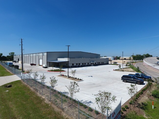
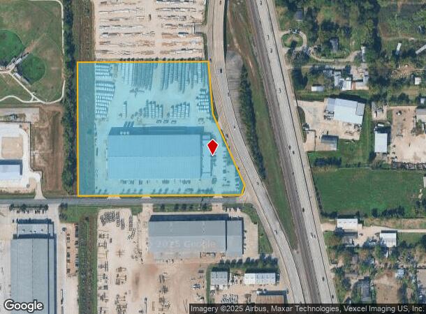
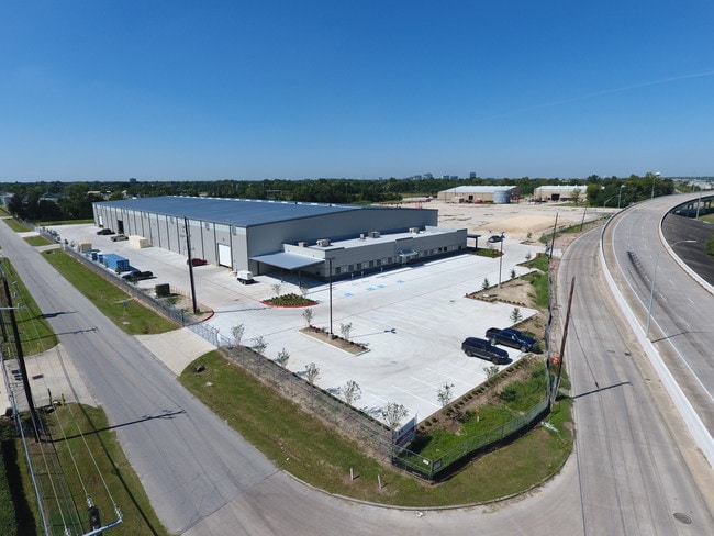
13717 W Hardy Rd, Houston, TX 77060
NEARBY LISTINGS FOR SALE OR LEASE
Property Detail
13717 W Hardy Rd
1396350010001
Hardy Road Industrial Park
Heavyindustrial
RES A BLK 1 HARDY ROAD INDUSTRIAL PARK
AE
Harris
48201C0470L
Texas
2024
10.52 AC
2025
North Outer Loop
222402
Houston
105,675 SF
Houston-The Woodlands-Sugar Land, TX
DEMOGRAPHICS near 13717 W Hardy Rd
1 Mile
3 Mile
5 Mile
2024 Total Population
6,364
91,800
256,823
2029 Population
6,398
93,029
260,925
Pop Growth 2024-2029
+ 0.53%
+ 1.34%
+ 1.60%
Average Age
34
33
34
2024 Total Households
1,732
27,786
77,828
HH Growth 2024-2029
+ 0.40%
+ 1.41%
+ 1.67%
Median Household Inc
$36,879
$36,334
$37,429
Avg Household Size
3.60
3.20
3.20
2024 Avg HH Vehicles
2.00
2.00
2.00
Median Home Value
$92,104
$130,443
$142,595
Median Year Built
1973
1976
1977
Nearby Places
Map Layers
Map Styles
 Street
 Aerial
- Restaurants
- Banks
- Shops
- Fitness
- Groceries
PUBLIC TRANSPORTATION
AIRPORT
George Bush Intcntl/Houston
DRIVE
WALK
Distance
George Bush Intcntl/Houston
14 min
9.9 mi
William P Hobby
DRIVE
WALK
Distance
William P Hobby
38 min
23.7 mi
Freight Ports
Port of Houston
DRIVE
WALK
Distance
Port of Houston
26 min
17.7 mi
SALE & LEASE HISTORY
LISTING DATE
SALE/LEASE

May 30, 2018
For Lease
May 30, 2018
For Sale
Nearby Properties
Address
Land Use
TOTAL SIZE
Lot Size
Zoning
Address
Land Use
TOTAL SIZE
Lot Size
Zoning
145.62 AC
Address
Land Use
TOTAL SIZE
Lot Size
Zoning
1,767,053 SF
88.85 AC
Address
Land Use
TOTAL SIZE
Lot Size
Zoning
704,105 SF
40.72 AC
Address
Land Use
TOTAL SIZE
Lot Size
Zoning
594,105 SF
43.68 AC
Address
Land Use
TOTAL SIZE
Lot Size
Zoning
500,000 SF
24.58 AC
Address
Land Use
TOTAL SIZE
Lot Size
Zoning
502,325 SF
25.13 AC
Address
Land Use
TOTAL SIZE
Lot Size
Zoning
523,480 SF
29.22 AC
Address
Land Use
TOTAL SIZE
Lot Size
Zoning
431,400 SF
30.88 AC
Address
Land Use
TOTAL SIZE
Lot Size
Zoning
368,632 SF
20.06 AC
Address
Land Use
TOTAL SIZE
Lot Size
Zoning
241,625 SF
11.10 AC
Address
Land Use
TOTAL SIZE
Lot Size
Zoning
350,500 SF
17.71 AC
Address
Land Use
TOTAL SIZE
Lot Size
Zoning
353,600 SF
23.45 AC
Address
Land Use
TOTAL SIZE
Lot Size
Zoning
423,730 SF
5.91 AC
Address
Land Use
TOTAL SIZE
Lot Size
Zoning
284,476 SF
20 AC
Address
Land Use
TOTAL SIZE
Lot Size
Zoning
383,451 SF
15.98 AC
Address
Land Use
TOTAL SIZE
Lot Size
Zoning
240,240 SF
14.35 AC
Address
Land Use
TOTAL SIZE
Lot Size
Zoning
251,812 SF
12.22 AC
Address
Land Use
TOTAL SIZE
Lot Size
Zoning
264,300 SF
15.89 AC
Address
Land Use
TOTAL SIZE
Lot Size
Zoning
244,864 SF
12.30 AC
Address
Land Use
TOTAL SIZE
Lot Size
Zoning
208,008 SF
8.32 AC
Address
Land Use
TOTAL SIZE
Lot Size
Zoning
244,760 SF
17.20 AC
Address
Land Use
TOTAL SIZE
Lot Size
Zoning
379,255 SF
22.65 AC
Address
Land Use
TOTAL SIZE
Lot Size
Zoning
293,270 SF
8.29 AC
Address
Land Use
TOTAL SIZE
Lot Size
Zoning
202,362 SF
8.02 AC
Address
Land Use
TOTAL SIZE
Lot Size
Zoning
90,033 SF
46.96 AC
Address
Land Use
TOTAL SIZE
Lot Size
Zoning
250,660 SF
14.22 AC
Address
Land Use
TOTAL SIZE
Lot Size
Zoning
193,972 SF
14.59 AC
Address
Land Use
TOTAL SIZE
Lot Size
Zoning
350,511 SF
15.40 AC
Address
Land Use
TOTAL SIZE
Lot Size
Zoning
109,025 SF
6 AC
Address
Land Use
TOTAL SIZE
Lot Size
Zoning
218,734 SF
11.24 AC
The World's #1 Commercial Real Estate Marketplace
Connect with us
© 2025 CoStar Group
The information above has been obtained from sources believed reliable. While we do not doubt its accuracy we have not verified it and make no guarantee, warranty or representation about it. It is your responsibility to independently confirm its accuracy and completeness. Any projections, opinions, assumptions, or estimates used are for example only and do not represent the current or future performance of the property. The value of this transaction to you depends on tax and other factors which should be evaluated by your tax, financial, and legal advisors. You and your advisors should conduct a careful, independent investigation of the property to determine to your satisfaction the suitability of the property for your needs.