Property Record
1372 Boggs Dr, Mount Airy, NC 27030

NEARBY LISTINGS FOR SALE OR LEASE
-
-
View all Mount Airy listings for lease on LoopNet.com
Property Detail
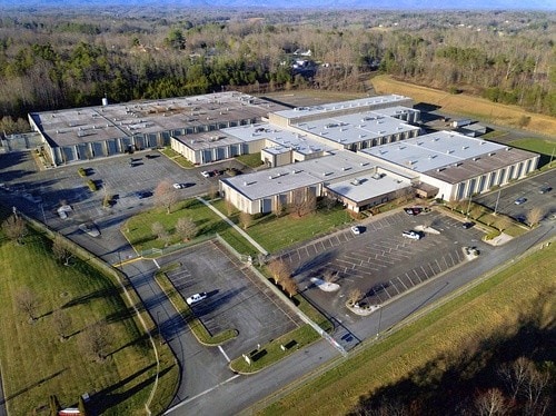
1372 Boggs Dr
5021-09-06-2103
Galax-Boggs
Heavymanufacturing
Surry
X
North Carolina
3711501100J
35 AC
2025
Hickory/Morganton
2025
Other Market Areas
930501
Mount Airy, NC
162,322 SF
DEMOGRAPHICS near 1372 Boggs Dr
1 Mile
3 Mile
5 Mile
2024 Total Population
1,659
14,346
26,632
2029 Population
1,667
14,480
26,853
Pop Growth 2024-2029
+ 0.48%
+ 0.93%
+ 0.83%
Average Age
46
44
44
2024 Total Households
721
6,315
11,597
HH Growth 2024-2029
+ 0.55%
+ 0.97%
+ 0.84%
Median Household Inc
$31,948
$49,699
$46,573
Avg Household Size
2.20
2.20
2.20
2024 Avg HH Vehicles
2.00
2.00
2.00
Median Home Value
$165,286
$170,287
$150,444
Median Year Built
1971
1973
1974
Nearby Places
Map Layers
Map Styles
 Street
 Aerial
- Restaurants
- Banks
- Shops
- Fitness
- Groceries
SALE & LEASE HISTORY
LISTING DATE
SALE/LEASE

Mar 19, 2020
For Lease
Feb 12, 2018
For Sale
Feb 09, 2018
For Sale
Nearby Properties
Address
Land Use
TOTAL SIZE
Lot Size
Zoning
Address
Land Use
TOTAL SIZE
Lot Size
Zoning
200,663 SF
10.49 AC
R8
Address
Land Use
TOTAL SIZE
Lot Size
Zoning
87,468 SF
41.57 AC
RA
Address
Land Use
TOTAL SIZE
Lot Size
Zoning
86,738 SF
29.44 AC
R6
Address
Land Use
TOTAL SIZE
Lot Size
Zoning
12,088 SF
37.77 AC
RL
Address
Land Use
TOTAL SIZE
Lot Size
Zoning
112,521 SF
10.33 AC
B4
Address
Land Use
TOTAL SIZE
Lot Size
Zoning
10,592 SF
18.17 AC
CU-B5
Address
Land Use
TOTAL SIZE
Lot Size
Zoning
77,952 SF
48 AC
HB
Address
Land Use
TOTAL SIZE
Lot Size
Zoning
79,958 SF
20.05 AC
R8
Address
Land Use
TOTAL SIZE
Lot Size
Zoning
9,180 SF
214 AC
MI
Address
Land Use
TOTAL SIZE
Lot Size
Zoning
39,656 SF
11.65 AC
B2
Address
Land Use
TOTAL SIZE
Lot Size
Zoning
51,045 SF
2.60 AC
R6
Address
Land Use
TOTAL SIZE
Lot Size
Zoning
26,394 SF
3.62 AC
M1
Address
Land Use
TOTAL SIZE
Lot Size
Zoning
36,664 SF
5.36 AC
B5
Address
Land Use
TOTAL SIZE
Lot Size
Zoning
171,232 SF
22.65 AC
M1
Address
Land Use
TOTAL SIZE
Lot Size
Zoning
49,606 SF
0.59 AC
B2
Address
Land Use
TOTAL SIZE
Lot Size
Zoning
54,310 SF
B4
Address
Land Use
TOTAL SIZE
Lot Size
Zoning
57,205 SF
6.03 AC
B2
Address
Land Use
TOTAL SIZE
Lot Size
Zoning
41,250 SF
4.78 AC
B2
Address
Land Use
TOTAL SIZE
Lot Size
Zoning
18,666 SF
2 AC
B4
Address
Land Use
TOTAL SIZE
Lot Size
Zoning
21,994 SF
2.50 AC
B2
Address
Land Use
TOTAL SIZE
Lot Size
Zoning
214,212 SF
27.17 AC
M1
Address
Land Use
TOTAL SIZE
Lot Size
Zoning
29,785 SF
4.90 AC
R8
Address
Land Use
TOTAL SIZE
Lot Size
Zoning
1,664 SF
6.20 AC
CU-R6
Address
Land Use
TOTAL SIZE
Lot Size
Zoning
13,298 SF
1.87 AC
B4
Address
Land Use
TOTAL SIZE
Lot Size
Zoning
79,794 SF
16.50 AC
B4
Address
Land Use
TOTAL SIZE
Lot Size
Zoning
19,282 SF
4.33 AC
R6
Address
Land Use
TOTAL SIZE
Lot Size
Zoning
5,312 SF
2.53 AC
B4
Address
Land Use
TOTAL SIZE
Lot Size
Zoning
36,739 SF
7.57 AC
B4
Address
Land Use
TOTAL SIZE
Lot Size
Zoning
205,777 SF
11.35 AC
M1
The World's #1 Commercial Real Estate Marketplace
Connect with us
© 2025 CoStar Group
The information above has been obtained from sources believed reliable. While we do not doubt its accuracy we have not verified it and make no guarantee, warranty or representation about it. It is your responsibility to independently confirm its accuracy and completeness. Any projections, opinions, assumptions, or estimates used are for example only and do not represent the current or future performance of the property. The value of this transaction to you depends on tax and other factors which should be evaluated by your tax, financial, and legal advisors. You and your advisors should conduct a careful, independent investigation of the property to determine to your satisfaction the suitability of the property for your needs.