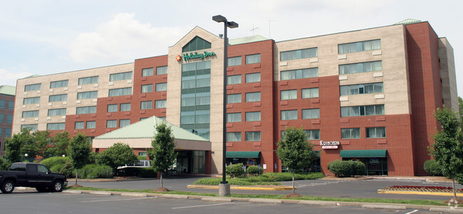
Property Record
13735 Riverport Dr, Maryland Heights, MO 63043

NEARBY LISTINGS FOR SALE OR LEASE
Property Detail
13735 Riverport Dr
St. Louis, MO-IL
Riverport Tract 1
11P-64-0106
RIVERPORT TRACT 1 AMENDED 11O430014 10 20 89 LOT 4
Hotel
St. Louis
X
Missouri
29183C0289G
4
2024
2.70 AC
2025
Northwest County
215143
St. Louis
94,506 SF
DEMOGRAPHICS near 13735 Riverport Dr
1 Mile
3 Mile
5 Mile
2024 Total Population
69
42,478
137,031
2029 Population
69
43,554
140,113
Pop Growth 2024-2029
0.00%
+ 2.53%
+ 2.25%
Average Age
45
40
41
2024 Total Households
34
18,054
59,371
HH Growth 2024-2029
0.00%
+ 2.64%
+ 2.25%
Median Household Inc
$65,625
$75,351
$72,207
Avg Household Size
2.00
2.20
2.20
2024 Avg HH Vehicles
2.00
2.00
2.00
Median Home Value
$184,615
$199,959
$224,336
Median Year Built
1968
1971
1974
Nearby Places
Map Layers
Map Styles
 Street
 Aerial
- Restaurants
- Banks
- Shops
- Fitness
- Groceries
PUBLIC TRANSPORTATION
COMMUTER RAIL
Lambert Airport East Terminal (Lambert Airport Shiloh-Scott - St. Louis MetroLink (MetroLink))
DRIVE
WALK
Distance
Lambert Airport East Terminal (Lambert Airport Shiloh-Scott - St. Louis MetroLink (MetroLink))
15 min
7.4 mi
Lambert Airport Main Terminal (Lambert Airport Shiloh-Scott - St. Louis MetroLink (MetroLink))
DRIVE
WALK
Distance
Lambert Airport Main Terminal (Lambert Airport Shiloh-Scott - St. Louis MetroLink (MetroLink))
17 min
7.9 mi
AIRPORT
St Louis Lambert International
DRIVE
WALK
Distance
St Louis Lambert International
16 min
9.0 mi
Scott AFB/Midamerica St Louis
DRIVE
WALK
Distance
Scott AFB/Midamerica St Louis
65 min
43.9 mi
Nearby Properties
Address
Land Use
TOTAL SIZE
Lot Size
Zoning
Address
Land Use
TOTAL SIZE
Lot Size
Zoning
2,918,475 SF
30.32 AC
AC1
Address
Land Use
TOTAL SIZE
Lot Size
Zoning
553,382 SF
109.67 AC
FPNU
Address
Land Use
TOTAL SIZE
Lot Size
Zoning
449,698 SF
47.19 AC
R3
Address
Land Use
TOTAL SIZE
Lot Size
Zoning
440,000 SF
2.11 AC
Address
Land Use
TOTAL SIZE
Lot Size
Zoning
256,719 SF
27 AC
104PDM
Address
Land Use
TOTAL SIZE
Lot Size
Zoning
833,525 SF
25.53 AC
R1
Address
Land Use
TOTAL SIZE
Lot Size
Zoning
1,190 SF
49.03 AC
104R-5
Address
Land Use
TOTAL SIZE
Lot Size
Zoning
564,552 SF
42.07 AC
10M-1
Address
Land Use
TOTAL SIZE
Lot Size
Zoning
542,500 SF
39.91 AC
FPNU
Address
Land Use
TOTAL SIZE
Lot Size
Zoning
332,323 SF
22.40 AC
104PDM
Address
Land Use
TOTAL SIZE
Lot Size
Zoning
662,199 SF
26.58 AC
10M-1
Address
Land Use
TOTAL SIZE
Lot Size
Zoning
488,536 SF
23.53 AC
AF0
Address
Land Use
TOTAL SIZE
Lot Size
Zoning
281,074 SF
8.79 AC
Address
Land Use
TOTAL SIZE
Lot Size
Zoning
312,516 SF
2.18 AC
Address
Land Use
TOTAL SIZE
Lot Size
Zoning
319,398 SF
15.58 AC
10M-3
Address
Land Use
TOTAL SIZE
Lot Size
Zoning
448,590 SF
24.75 AC
M3
Address
Land Use
TOTAL SIZE
Lot Size
Zoning
120,050 SF
1.51 AC
Address
Land Use
TOTAL SIZE
Lot Size
Zoning
158,499 SF
27.01 AC
FPM3
Address
Land Use
TOTAL SIZE
Lot Size
Zoning
353,407 SF
21.84 AC
104R-4
Address
Land Use
TOTAL SIZE
Lot Size
Zoning
67,891 SF
4 AC
R3
Address
Land Use
TOTAL SIZE
Lot Size
Zoning
205,107 SF
13.43 AC
104PDM
Address
Land Use
TOTAL SIZE
Lot Size
Zoning
317,145 SF
21.71 AC
10M-1
Address
Land Use
TOTAL SIZE
Lot Size
Zoning
232,353 SF
21.13 AC
104PDM
Address
Land Use
TOTAL SIZE
Lot Size
Zoning
403,200 SF
21.99 AC
10M-1
Address
Land Use
TOTAL SIZE
Lot Size
Zoning
316,064 SF
1.84 AC
Address
Land Use
TOTAL SIZE
Lot Size
Zoning
124,000 SF
5.15 AC
102COMCL
Address
Land Use
TOTAL SIZE
Lot Size
Zoning
119,925 SF
72.26 AC
10M-1
Address
Land Use
TOTAL SIZE
Lot Size
Zoning
494,400 SF
26.26 AC
FPM3
Address
Land Use
TOTAL SIZE
Lot Size
Zoning
251,050 SF
12.36 AC
FPM3
Address
Land Use
TOTAL SIZE
Lot Size
Zoning
100,633 SF
1.02 AC
The World's #1 Commercial Real Estate Marketplace
Connect with us
© 2026 CoStar Group
The information above has been obtained from sources believed reliable. While we do not doubt its accuracy we have not verified it and make no guarantee, warranty or representation about it. It is your responsibility to independently confirm its accuracy and completeness. Any projections, opinions, assumptions, or estimates used are for example only and do not represent the current or future performance of the property. The value of this transaction to you depends on tax and other factors which should be evaluated by your tax, financial, and legal advisors. You and your advisors should conduct a careful, independent investigation of the property to determine to your satisfaction the suitability of the property for your needs.