Property Record
1375 Hewatt Rd Sw, Lilburn, GA 30047
NEARBY LISTINGS FOR SALE OR LEASE
-
-
-
-
-
No Photo
-
View all Lilburn listings for sale on LoopNet.com
Property Detail
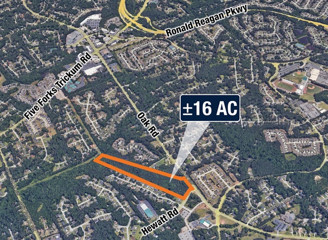
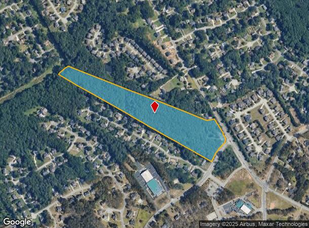
1375 Hewatt Rd Sw
6-086-007
HEWATT RD
Residentialacreage
Gwinnett
AE
Georgia
13135C0128F
16.04 AC
2025
Lawrenceville/Lilburn
2025
Atlanta
050461
Atlanta-Sandy Springs-Roswell, GA
DEMOGRAPHICS near 1375 Hewatt Rd Sw
1 mile
3 mile
5 mile
2024 Total Population
7,275
70,916
204,270
2029 Population
7,559
73,999
212,830
Pop Growth 2024-2029
+ 3.90%
+ 4.35%
+ 4.19%
Average Age
39
39
38
2024 Total Households
2,284
22,644
65,267
HH Growth 2024-2029
+ 3.90%
+ 4.43%
+ 4.24%
Median Household Inc
$106,356
$94,707
$82,807
Avg Household Size
3.20
3.10
3.10
2024 Avg HH Vehicles
2.00
2.00
2.00
Median Home Value
$321,980
$315,911
$293,189
Median Year Built
1986
1987
1989
Nearby Places
Map Layers
Map Styles
 Street
 Aerial
Transit
 Traffic
 Biking
Places
Listings with unknown addresses are not visible on the map
- Restaurants
- Banks
- Shops
- Fitness
- Groceries
PUBLIC TRANSPORTATION
AIRPORT
Hartsfield - Jackson Atlanta International
Drive
Walk
Distance
Hartsfield - Jackson Atlanta International
50 min
33.0 mi
Freight Ports
Georgia Ports - Savannah
Drive
Walk
Distance
Georgia Ports - Savannah
303 min
264.8 mi
SALE & LEASE HISTORY
LISTING DATE
SALE/LEASE

Jun 10, 2022
For Sale
Jul 11, 2018
For Sale
Jan 19, 2017
For Sale
Apr 20, 2017
For Sale
Nearby Properties
Address
Land Use
TOTAL SIZE
Lot Size
Zoning
Address
Land Use
TOTAL SIZE
Lot Size
Zoning
362,674 SF
43.59 AC
CI
Address
Land Use
TOTAL SIZE
Lot Size
Zoning
301,646 SF
23.90 AC
RM13
Address
Land Use
TOTAL SIZE
Lot Size
Zoning
313,246 SF
17.15 AC
RM13
Address
Land Use
TOTAL SIZE
Lot Size
Zoning
319,290 SF
2.05 AC
TC-MU
Address
Land Use
TOTAL SIZE
Lot Size
Zoning
245,208 SF
15.37 AC
RO
Address
Land Use
TOTAL SIZE
Lot Size
Zoning
278,756 SF
27.72 AC
RM
Address
Land Use
TOTAL SIZE
Lot Size
Zoning
274,964 SF
27.82 AC
BG
Address
Land Use
TOTAL SIZE
Lot Size
Zoning
230,417 SF
24.09 AC
BG
Address
Land Use
TOTAL SIZE
Lot Size
Zoning
214,082 SF
18.56 AC
BG
Address
Land Use
TOTAL SIZE
Lot Size
Zoning
283,953 SF
20.56 AC
RS30
Address
Land Use
TOTAL SIZE
Lot Size
Zoning
148,880 SF
23.15 AC
R100
Address
Land Use
TOTAL SIZE
Lot Size
Zoning
125,097 SF
1.01 AC
CI
Address
Land Use
TOTAL SIZE
Lot Size
Zoning
357,243 SF
59.63 AC
R100
Address
Land Use
TOTAL SIZE
Lot Size
Zoning
123,713 SF
5.97 AC
C2
Address
Land Use
TOTAL SIZE
Lot Size
Zoning
53,071 SF
142.06 AC
R75
Address
Land Use
TOTAL SIZE
Lot Size
Zoning
113,100 SF
11.39 AC
C2
Address
Land Use
TOTAL SIZE
Lot Size
Zoning
38,438 SF
130.10 AC
R100
Address
Land Use
TOTAL SIZE
Lot Size
Zoning
139,448 SF
15.97 AC
RM
Address
Land Use
TOTAL SIZE
Lot Size
Zoning
202,864 SF
1.35 AC
TC-MU
Address
Land Use
TOTAL SIZE
Lot Size
Zoning
131,121 SF
12.99 AC
BG
Address
Land Use
TOTAL SIZE
Lot Size
Zoning
218,973 SF
21.04 AC
BG
Address
Land Use
TOTAL SIZE
Lot Size
Zoning
79,339 SF
38.25 AC
RS180
Address
Land Use
TOTAL SIZE
Lot Size
Zoning
120,113 SF
13 AC
BG
Address
Land Use
TOTAL SIZE
Lot Size
Zoning
99,280 SF
4.51 AC
C2
Address
Land Use
TOTAL SIZE
Lot Size
Zoning
122,201 SF
10.23 AC
BG
Address
Land Use
TOTAL SIZE
Lot Size
Zoning
100,913 SF
8.30 AC
HSB
Address
Land Use
TOTAL SIZE
Lot Size
Zoning
106,114 SF
16.59 AC
C2
Address
Land Use
TOTAL SIZE
Lot Size
Zoning
97,411 SF
8.47 AC
BG
Address
Land Use
TOTAL SIZE
Lot Size
Zoning
111,732 SF
9.71 AC
CI
Address
Land Use
TOTAL SIZE
Lot Size
Zoning
55,810 SF
8.28 AC
R100
The World's #1 Commercial Real Estate Marketplace
Connect with us
© 2026 CoStar Group
The information above has been obtained from sources believed reliable. While we do not doubt its accuracy we have not verified it and make no guarantee, warranty or representation about it. It is your responsibility to independently confirm its accuracy and completeness. Any projections, opinions, assumptions, or estimates used are for example only and do not represent the current or future performance of the property. The value of this transaction to you depends on tax and other factors which should be evaluated by your tax, financial, and legal advisors. You and your advisors should conduct a careful, independent investigation of the property to determine to your satisfaction the suitability of the property for your needs.