Property Record
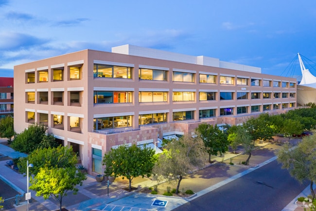
1375 N Scottsdale Rd, Scottsdale, AZ 85257


Current Lease Availabilities
NEARBY LISTINGS FOR SALE OR LEASE
Property Detail
1375 N Scottsdale Rd
Phoenix-Mesa-Chandler, AZ
PAR LD LY WI/IN NW4 SEC 2 DAF COM AT NW COR SD SEC TH S 1390.44F TH N 88D 59M E 1154.78F TH N 73D 02M E 164.31F TH NLY ALG CUR 160.10F TH N 297.62F TH W 24.99F TH WLY ALG CUR 10.08F TH S 82D 14M W 103.02F TH WLY ALG CUR 6.70F TH W 18.97F TO POB TH W
131-17-014L
Maricopa
Officebuilding
Arizona
2025
1.43 AC
2025
Scottsdale South
218200
Phoenix
155,988 SF
DEMOGRAPHICS near 1375 N Scottsdale Rd
1 Mile
3 Mile
5 Mile
2024 Total Population
19,849
113,504
297,125
2029 Population
21,852
125,077
324,228
Pop Growth 2024-2029
+ 10.09%
+ 10.20%
+ 9.12%
Average Age
38
38
36
2024 Total Households
8,866
56,386
133,521
HH Growth 2024-2029
+ 10.17%
+ 10.47%
+ 9.54%
Median Household Inc
$88,286
$74,015
$68,084
Avg Household Size
2.10
1.90
2.10
2024 Avg HH Vehicles
2.00
2.00
2.00
Median Home Value
$413,068
$439,678
$443,561
Median Year Built
1973
1981
1979
Nearby Places
Map Layers
Map Styles
 Street
 Aerial
- Restaurants
- Banks
- Shops
- Fitness
- Groceries
PUBLIC TRANSPORTATION
AIRPORT
Phoenix Sky Harbor International
DRIVE
WALK
Distance
Phoenix Sky Harbor International
12 min
6.9 mi
Phoenix-Mesa Gateway
DRIVE
WALK
Distance
Phoenix-Mesa Gateway
38 min
26.0 mi
Freight Ports
Port of San Diego
DRIVE
WALK
Distance
Port of San Diego
407 min
363.8 mi
Nearby Properties
Address
Land Use
TOTAL SIZE
Lot Size
Zoning
Address
Land Use
TOTAL SIZE
Lot Size
Zoning
Address
Land Use
TOTAL SIZE
Lot Size
Zoning
4.59 AC
I-1
Address
Land Use
TOTAL SIZE
Lot Size
Zoning
1,870,689 SF
46.77 AC
I-P
Address
Land Use
TOTAL SIZE
Lot Size
Zoning
75,000 SF
12.19 AC
I-1
Address
Land Use
TOTAL SIZE
Lot Size
Zoning
2,636,740 SF
21.88 AC
C-DT
Address
Land Use
TOTAL SIZE
Lot Size
Zoning
Address
Land Use
TOTAL SIZE
Lot Size
Zoning
401,544 SF
64.59 AC
GID
Address
Land Use
TOTAL SIZE
Lot Size
Zoning
1,102,629 SF
12.33 AC
R-3
Address
Land Use
TOTAL SIZE
Lot Size
Zoning
2.54 AC
Address
Land Use
TOTAL SIZE
Lot Size
Zoning
9,160 SF
2.57 AC
DDMU2
Address
Land Use
TOTAL SIZE
Lot Size
Zoning
3.77 AC
PNC
Address
Land Use
TOTAL SIZE
Lot Size
Zoning
44,971 SF
2.06 AC
C-R
Address
Land Use
TOTAL SIZE
Lot Size
Zoning
58,061 SF
5.43 AC
C-C
Address
Land Use
TOTAL SIZE
Lot Size
Zoning
697,894 SF
8.43 AC
PAD
Address
Land Use
TOTAL SIZE
Lot Size
Zoning
3,010 SF
35.44 AC
R110
Address
Land Use
TOTAL SIZE
Lot Size
Zoning
511,014 SF
5.01 AC
I-1
Address
Land Use
TOTAL SIZE
Lot Size
Zoning
307,604 SF
37.83 AC
R-7
Address
Land Use
TOTAL SIZE
Lot Size
Zoning
688,550 SF
149.95 AC
R-6
Address
Land Use
TOTAL SIZE
Lot Size
Zoning
548,227 SF
1.62 AC
C-G
Address
Land Use
TOTAL SIZE
Lot Size
Zoning
776,898 SF
27.32 AC
C-R
Address
Land Use
TOTAL SIZE
Lot Size
Zoning
654,960 SF
19.48 AC
R-6
Address
Land Use
TOTAL SIZE
Lot Size
Zoning
544,646 SF
1.65 AC
MU4
Address
Land Use
TOTAL SIZE
Lot Size
Zoning
285,883 SF
12.62 AC
I-1
Address
Land Use
TOTAL SIZE
Lot Size
Zoning
518,223 SF
3.54 AC
C-C
Address
Land Use
TOTAL SIZE
Lot Size
Zoning
401,437 SF
17.70 AC
C-R
Address
Land Use
TOTAL SIZE
Lot Size
Zoning
831,861 SF
4.25 AC
MU4
The World's #1 Commercial Real Estate Marketplace
Connect with us
© 2026 CoStar Group
The information above has been obtained from sources believed reliable. While we do not doubt its accuracy we have not verified it and make no guarantee, warranty or representation about it. It is your responsibility to independently confirm its accuracy and completeness. Any projections, opinions, assumptions, or estimates used are for example only and do not represent the current or future performance of the property. The value of this transaction to you depends on tax and other factors which should be evaluated by your tax, financial, and legal advisors. You and your advisors should conduct a careful, independent investigation of the property to determine to your satisfaction the suitability of the property for your needs.